Kharan District
| Kharan District | |
|---|---|
| District | |
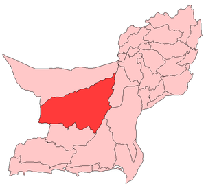 Map of Balochistan with Kharan District highlighted | |
| Country | Pakistan |
| Province | Balochistan |
| Established | March 15, 1952 |
| Headquarters | Kharan |
| Area | |
| • Total | 8,958 km2 (3,459 sq mi) |
| Population (1998) | |
| • Total | 96,900 |
| • Density | 10.81/km2 (28.0/sq mi) |
| Time zone | PST (UTC+5) |
| Number of Tehsils | 1 |
Kharan (Urdu and Balochi: خاران) is a district in the Balochistan province of Pakistan.
Government
The district includes with 2 tehsil, administratively divided into nine union councils.[2]
See also
References
External links
 |
Wikimedia Commons has media related to Kharan District. |

Coordinates: 28°00′N 64°30′E / 28.000°N 64.500°E
This article is issued from Wikipedia - version of the 11/10/2016. The text is available under the Creative Commons Attribution/Share Alike but additional terms may apply for the media files.