Kingston Mill Historic District
|
Kingston Mill Historic District | |
|
The Kingston Mill | |
|
The boundaries of the historic district, on the border between Princeton and Kingston, New Jersey | |
| Location | A farm, mill and bridge in the easternmost portion of Princeton, New Jersey around the Princeton-Kingston Road |
|---|---|
| Coordinates | 40°22′24.9″N 74°37′14.3″W / 40.373583°N 74.620639°W |
| Area | 49 acres (20 ha) |
| Built | 1755 (original mill), 1798 (bridge), 1888 (current mill) |
| Architect | Multiple |
| Architectural style | Vernacular, Federal, Colonial |
| NRHP Reference # | 86000707 |
| NJRHP # | 1746[1] |
| Significant dates | |
| Added to NRHP | April 10, 1986 |
| Designated NJRHP | March 5, 1986 |

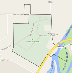
The Kingston Mill Historic District is made up of the Greenland-Brinson-Gulick farm, four nearby houses, the eponymous gristmill powered by the Millstone River, and the Kingston Bridge, an 18th-century stone arch bridge over the river. It was one of the first settlements in Princeton, New Jersey, preceded only by the Quaker community along the Stony Brook.[2]
Gallery
 The Kingston Mill (1888), built to replace one built in 1755, from the Kingston Bridge
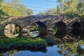 The Kingston Bridge (1798), built to replace one demolished by George Washington's troops to prevent British pursuit
 The mile marker from 1798, showing the distance to Philadelphia (45 miles) and New York City (50 miles)
See also
 |
Wikimedia Commons has media related to Kingston Mill Historic District. |
References
- ↑ "New Jersey and National Registers of Historic Places — Mercer County" (PDF). New Jersey Department of Environmental Protection — Historic Preservation Office. April 5, 2013. p. 8. Retrieved June 4, 2013.
- ↑ Craig, Robert. "Kingston Mill Historic District" (PDF). National Register off Historic Places Inventory—Nomination Form. National Park Service.
Areas |  | |
| Historic Districts | ||
| Former municipalities | ||
Education | ||
| Public schools | ||
| Independent schools | ||
| Colleges and universities | ||
| Other education | ||
Other | ||
| Places of Worship | ||
| Parks and Recreation | ||
| Shopping, and Dining | ||
| Performing Arts | ||
| Media | ||
| Other landmarks | ||
| Princeton addressed landmarks outside the municipality | ||
See also: Princeton University and National Register of Historic Places listings in Mercer County, New Jersey | ||
This article is issued from Wikipedia - version of the 12/1/2016. The text is available under the Creative Commons Attribution/Share Alike but additional terms may apply for the media files.