Kirovohrad Raion
| Kirovohrad Raion Кіровоградський район | |||
|---|---|---|---|
| Raion | |||
| |||
 | |||
| Coordinates: 48°31′43″N 32°25′22″E / 48.52861°N 32.42278°ECoordinates: 48°31′43″N 32°25′22″E / 48.52861°N 32.42278°E | |||
| Country |
 Ukraine Ukraine | ||
| Region | Kirovohrad Oblast | ||
| Established | 1923 | ||
| Admin. center | Kropyvnytskyi | ||
| Subdivisions |
List
| ||
| Government | |||
| • Governor | Andriy Malytskiy | ||
| Area | |||
| • Total | 1,600 km2 (600 sq mi) | ||
| Population (2013) | |||
| • Total |
 37,409 37,409 | ||
| Time zone | EET (UTC+2) | ||
| • Summer (DST) | EEST (UTC+3) | ||
| Postal index | 27601—27657 | ||
| Area code | +380 522 | ||
| Website | http://kirrda.kr-admin.gov.ua | ||

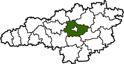
Kirovohrad Raion is a raion (district) of Kirovohrad Oblast in central Ukraine. Its administrative center is the city of Kropyvnytskyi (until July 2016 Kirovohrad), which is incorporated separately as a city of oblast significance and does not belong to the raion. Population: 37,409 (2013 est.)[1].
References
- ↑ "Чисельність наявного населення України (Actual population of Ukraine)" (in Ukrainian). State Statistics Service of Ukraine. Retrieved 21 January 2015.
| Raions |  | ||||||
|---|---|---|---|---|---|---|---|
| Cities |
| ||||||
| |||||||
This article is issued from Wikipedia - version of the 7/23/2016. The text is available under the Creative Commons Attribution/Share Alike but additional terms may apply for the media files.