Kōya, Wakayama
| Kōya 高野町 | |
|---|---|
| Town | |
|
View of sightseeing of Mount Koya spot, with one of UNESCO World Heritage site | |
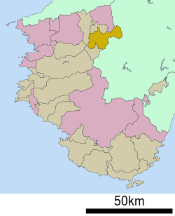 Location of Kōya in Wakayama Prefecture | |
  Kōya Location in Japan | |
| Coordinates: 34°13′N 135°35′E / 34.217°N 135.583°ECoordinates: 34°13′N 135°35′E / 34.217°N 135.583°E | |
| Country | Japan |
| Region | Kansai |
| Prefecture | Wakayama Prefecture |
| District | Ito |
| Government | |
| • Mayor | Takeji Kise (since May 2010) |
| Area | |
| • Total | 137.08 km2 (52.93 sq mi) |
| Population (October 1, 2010) | |
| • Total | 3,879 |
| • Density | 28/km2 (73/sq mi) |
| Symbols | |
| • Tree | Sciadopitys verticillata |
| • Flower | Rhododendron |
| Time zone | Japan Standard Time (UTC+9) |
| City hall address |
Oji Koyasan 636, Koya Town, Ito District, Wakayama Prefecture (和歌山県伊都郡高野町大字高野山636) 648-0281 |
| Website |
www |
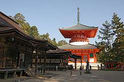
Kōya (高野町 Kōya-chō) is a town located on a plateau atop Mt. Koya in Ito District, Wakayama Prefecture, Japan. The town is known as the headquarters of the Shingon sect of Japanese Buddhism.
As of October 1, 2010, the town has an estimated population of 3,879 and a density of 28.30 persons per km². The total area is 137.08 km².
External links
 Media related to Kōya, Wakayama at Wikimedia Commons
- Kōya official website (Japanese)
This article is issued from Wikipedia - version of the 11/8/2015. The text is available under the Creative Commons Attribution/Share Alike but additional terms may apply for the media files.