Kozakai, Aichi
| Kozakai 小坂井町 | |
|---|---|
| Former municipality | |
|
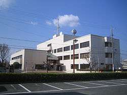
Kozakai Town Office | |
 Location of Kozakai in Aichi Prefecture | |
  Kozakai Location in Japan | |
| Coordinates: 34°48′N 137°22′E / 34.800°N 137.367°ECoordinates: 34°48′N 137°22′E / 34.800°N 137.367°E | |
| Country | Japan |
| Region | Chūbu (Tōkai) |
| Prefecture | Aichi Prefecture |
| District | Hoi |
| Merged |
February 1, 2010 (now part of Toyokawa) |
| Area | |
| • Total | 9.92 km2 (3.83 sq mi) |
| Population (November 1, 2007) | |
| • Total | 21,708 |
| • Density | 2,188.31/km2 (5,667.7/sq mi) |
| Symbols | |
| • Tree | Osmanthus |
| • Flower | Satsuki azalea |
| Time zone | Japan Standard Time (UTC+9) |
| Website | City of Toyokawa |
Kozakai (小坂井町 Kozakai-chō) was a town located in Hoi District, Aichi Prefecture, Japan.
As of November 1, 2007, (the last census information available) the town had an estimated population of 22,708 and a population density of 2,188.31 persons per km². The total area was 9.92 km².
On February 1, 2010, Kozakai was merged into the expanded city of Toyokawa. Therefore, Hoi District was dissolved as a result of this merger.
History
- October 1, 1889 - Toyoaki Village (豊秋村) was founded.
- September 12, 1906 - Kozakai Village was founded by the unification of Toyoaki Village and Ina Village (伊奈村).
- September 12, 1926 - Kozakai Town was founded.
- 1973 - Toyokawa Shinkin Bank Incident (豊川信用金庫事件 Toyokawa Shin'yō Kinko Jiken) occurred.
- 1993 - Kozakai Town Cultural Hall (小坂井町文化会館) was completed.
- February 1, 2010 - Kozakai merged with the city of Toyokawa.
Education
Primary schools
- Kozakai Nishi Primary School
- Kozakai Higashi Primary School
Junior High school
- Kozakai Junior High School
High school
- Kozakai High School
Social education
Ceremony Hall
- Kozakai Town Cultural Hall (小坂井町文化会館 Kozakai-chō Bunka Kaikan ; commonly called "Freuden Hall")
Transportation
Railway
Road
National highway
Local attractions
.jpg)
Gosha Inari
- Utari Jinja (菟足神社)
- Gosha Inari (五社稲荷)
- Ruins of Ina Castle (伊奈城趾)
Noted persons from Kozakai
- Yasuhiko Okada (岡田 康彦 Okada Yasuhiko) - Former Administrative Vice-Minister of the Environment of Japan
External links
 Media related to Kozakai, Aichi at Wikimedia Commons
- Toyokawa Official website (Japanese)
This article is issued from Wikipedia - version of the 9/4/2015. The text is available under the Creative Commons Attribution/Share Alike but additional terms may apply for the media files.