Lake Sabrina
| Lake Sabrina | |
|---|---|
 | |
| Location | Inyo County, California |
| Coordinates | 37°12′26″N 118°37′07″W / 37.2072689°N 118.618698°WCoordinates: 37°12′26″N 118°37′07″W / 37.2072689°N 118.618698°W |
| Type | reservoir |
| Primary outflows | Middle Fork Bishop Creek |
| Catchment area | 15.1 square miles (39 km2)[1] |
| Basin countries | United States |
| Built | 1907 |
| Surface area | 184 acres (74 ha)[1] |
| Water volume | 8,376 acre feet (10,332,000 m3)[1] |
| Surface elevation | 9,128 feet (2,782 m) |
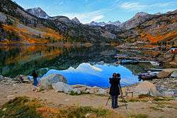
Lake Sabrina is a lake created by damming the middle fork of Bishop Creek.[2] It is located south-west of Bishop, California on California State Route 168, in the Inyo National Forest.[3] It has a cafe as well as a dock. The dam was built in 1907-8 to supply a constant flow of water to the hydraulic power plants.[4] The lake is part of the Bishop Creek system.
Local residents pronounce the lake "Sah-bry-nuh;"[5] however, the lake was originally named after Mrs. Sabrina (pronounced: suh-BREE-nuh) Hobbs, wife of C.M. Hobbs first General Manager of California Nevada Power Company which built the dam. The reason for the lake's name pronunciation changing over the years is unclear.[4]
See also
References
- 1 2 3 "Dams Within the Jurisdiction of the State of California (N-S)" (PDF). California Department of Water Resources, Division of Safety of Dams. Retrieved November 3, 2012.
- ↑ "Lake Sabrina". Geographic Names Information System. United States Geological Survey.
- ↑ Secor, R.J. (1999). The High Sierra: Peaks, Passes, and Trails. The Mountaineers. p. 258.
- 1 2 "History of the Canyon". Lake Sabrina Boat Landing. Retrieved 2013-04-22.
- ↑ Koehler, Cheryl (2007). Touring the Sierra Nevada. University of Nevada Press. p. 135.
External links
- Lake Sabrina Boat Landing
- Bishop Creek Canyon
- Historic American Engineering Record (HAER) No. CA-145-2-A, "Bishop Creek Hydroelectric System, Plant 2, Lake Sabrina Dam, Bishop Creek, Bishop vicinity, Inyo County, CA"
This article is issued from Wikipedia - version of the 10/7/2016. The text is available under the Creative Commons Attribution/Share Alike but additional terms may apply for the media files.