Leira, Oppland
| Nord-Aurdal kommune | |||
|---|---|---|---|
| Municipality | |||
|
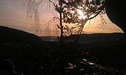
Leira from Bergflagget | |||
| |||
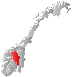
 Nord-Aurdal within Oppland | |||
| Coordinates: 60°57′35″N 9°15′51″E / 60.95972°N 9.26417°ECoordinates: 60°57′35″N 9°15′51″E / 60.95972°N 9.26417°E | |||
| Country | Norway | ||
| County | Oppland | ||
| District | Valdres | ||
| Administrative centre | Fagernes | ||
| Government | |||
| • Mayor (2003) | Svein Erik F. Hilmen (Sp) | ||
| Area | |||
| • Total | 907 km2 (350 sq mi) | ||
| • Land | 850 km2 (330 sq mi) | ||
| Area rank | 122 in Norway | ||
| Population (2004) | |||
| • Total | 6,539 | ||
| • Rank | 151 in Norway | ||
| • Density | 8/km2 (20/sq mi) | ||
| • Change (10 years) | -0.9 % | ||
| Demonym(s) | Nordaurdøl[1] | ||
| Time zone | CET (UTC+1) | ||
| • Summer (DST) | CEST (UTC+2) | ||
| ISO 3166 code | NO-0542 | ||
| Official language form | Neutral | ||
| Website |
www | ||
|
| |||
For other places with the same name, see Leira (disambiguation).
Leira i Valdres is a village in Nord-Aurdal municipality, Norway. Its population is 861, in 2014.[2]
The name
The place is named after the river Leira. The name of the river is derived from leire 'clay'. Leira is a common name of rivers many places in Norway.
References
- ↑ "Navn på steder og personer: Innbyggjarnamn" (in Norwegian). Språkrådet. Retrieved 2015-12-01.
- ↑ no:Leira
This article is issued from Wikipedia - version of the 12/5/2016. The text is available under the Creative Commons Attribution/Share Alike but additional terms may apply for the media files.