Les Anglais, Les Anglais, Haiti
| Les Anglais | |
|---|---|
| Town | |
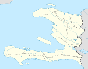  Les Anglais | |
| Coordinates: 18°18′29″N 74°13′09″W / 18.308105°N 74.2191052°WCoordinates: 18°18′29″N 74°13′09″W / 18.308105°N 74.2191052°W | |
| Country |
 Haiti Haiti |
| Department | Sud |
| Arrondissement | Chardonnières |
| Elevation | 11 m (36 ft) |
| Population (2009) | |
| • Total | 7,791 |
Les Anglais (English: The English) is a town in the Les Anglais commune of the Chardonnières Arrondissement, in the Sud Department of Haiti. In 2009, the city had a population of 7,791. [3] The eye of Hurricane Matthew made landfall near Les Anglais on 4 October 2016 at 6 a.m. EST (11:00 a.m. UTC) as a powerful Category 4 hurricane with winds of 230 km/h (145 mph).[4]
See also
References
- ↑ Google (29 August 2014). "Location" (Map). Google Maps. Google. Retrieved 29 August 2014.
- ↑ "National Geospatial-Intelligence Agency". GeoNames Search. Retrieved 29 August 2014.
- ↑ "IHSI" (PDF). Institut Haïtien de Statistique et D’Informatique. Archived from the original (PDF) on November 24, 2014. Retrieved 30 August 2014.
- ↑ Avila, Lixion (4 October 2016). "Hurricane Matthew Intermediate Advisory 25a". National Hurricane Center. Retrieved 5 October 2016.
Matthew made landfall near Les Anglais about 700 AM EDT (1100 UTC)....Maximum sustained winds remain near 145 mph (230 km/h) with higher gusts. Matthew is a category 4 hurricane on the Saffir- Simpson Hurricane Wind Scale.
This article is issued from Wikipedia - version of the 10/5/2016. The text is available under the Creative Commons Attribution/Share Alike but additional terms may apply for the media files.