List of mountains in Chouteau County, Montana
This list is incomplete; you can help by expanding it.
There are at least 58 named mountains in Chouteau County, Montana.
- Antelope Butte, 47°31′10″N 110°10′28″W / 47.51944°N 110.17444°W, el. 3,819 feet (1,164 m)[1]
- Arrow Peak, 47°25′32″N 110°31′35″W / 47.42556°N 110.52639°W, el. 7,447 feet (2,270 m)[2]
- Black Butte, 48°14′12″N 110°32′40″W / 48.23667°N 110.54444°W, el. 3,038 feet (926 m)[3]
- Black Mountain, 48°09′30″N 109°42′02″W / 48.15833°N 109.70056°W, el. 6,247 feet (1,904 m)[4]
- Black Rock, 47°56′31″N 110°11′06″W / 47.94194°N 110.18500°W, el. 2,894 feet (882 m)[5]
- Buckskin Butte, 47°30′11″N 110°13′10″W / 47.50306°N 110.21944°W, el. 3,822 feet (1,165 m)[6]
- Carter Mountain, 47°33′37″N 110°31′31″W / 47.56028°N 110.52528°W, el. 5,482 feet (1,671 m)[7]
- Centennial Mountain, 48°12′34″N 109°50′13″W / 48.20944°N 109.83694°W, el. 5,807 feet (1,770 m)[8]
- Chase Hill, 47°48′02″N 109°33′55″W / 47.80056°N 109.56528°W, el. 3,241 feet (988 m)[9]
- Chimney Rock, 47°57′26″N 110°11′43″W / 47.95722°N 110.19528°W, el. 2,821 feet (860 m)[10]
- Chinaman Hill, 47°51′53″N 110°44′22″W / 47.86472°N 110.73944°W, el. 3,091 feet (942 m)[11]
- Churchill Butte, 47°52′38″N 110°24′56″W / 47.87722°N 110.41556°W, el. 2,926 feet (892 m)[12]
- Dark Butte, 47°46′37″N 109°55′59″W / 47.77694°N 109.93306°W, el. 3,084 feet (940 m)[13]
- Discovery Butte, 48°07′52″N 110°36′26″W / 48.13111°N 110.60722°W, el. 3,113 feet (949 m)[14]
- Dunbar Hill, 47°34′31″N 110°48′13″W / 47.57528°N 110.80361°W, el. 3,484 feet (1,062 m)[15]
- Eagle Buttes, 47°51′11″N 110°01′52″W / 47.85306°N 110.03111°W, el. 2,940 feet (900 m)[16]
- East Knee, 48°00′34″N 111°16′39″W / 48.00944°N 111.27750°W, el. 3,697 feet (1,127 m)[17]
- East Peak, 47°25′33″N 110°28′05″W / 47.42583°N 110.46806°W, el. 6,965 feet (2,123 m)[18]
- Flying A Butte, 48°06′03″N 109°49′21″W / 48.10083°N 109.82250°W, el. 4,849 feet (1,478 m)[19]
- Fortress Rock, 47°58′11″N 110°07′01″W / 47.96972°N 110.11694°W, el. 2,687 feet (819 m)[20]
- Fourmile Hill, 47°46′11″N 109°42′11″W / 47.76972°N 109.70306°W, el. 2,644 feet (806 m)[21]
- Goose Bill Butte, 48°03′47″N 110°48′17″W / 48.06306°N 110.80472°W, el. 3,763 feet (1,147 m)[22]
- Gossack Mountain, 47°32′05″N 110°41′46″W / 47.53472°N 110.69611°W, el. 5,187 feet (1,581 m)[23]
- Harris Mountain, 47°31′48″N 110°44′04″W / 47.53000°N 110.73444°W, el. 5,069 feet (1,545 m)[24]
- Hay Stack Coulee, 48°00′01″N 111°10′08″W / 48.00028°N 111.16889°W, el. 3,560 feet (1,090 m)[25]
- Haystack Butte, 47°38′15″N 110°13′21″W / 47.63750°N 110.22250°W, el. 3,287 feet (1,002 m)[26]
- Haystack Butte, 48°02′40″N 109°36′06″W / 48.04444°N 109.60167°W, el. 4,111 feet (1,253 m)[27]
- Haystack Butte, 47°54′33″N 109°52′20″W / 47.90917°N 109.87222°W, el. 3,195 feet (974 m)[28]
- Highwood Baldy, 47°26′33″N 110°37′52″W / 47.44250°N 110.63111°W, el. 7,657 feet (2,334 m)[29]
- Johnson Hill, 47°46′02″N 109°38′38″W / 47.76722°N 109.64389°W, el. 2,963 feet (903 m)[30]
- Libby Hills, 47°27′44″N 110°22′24″W / 47.46222°N 110.37333°W, el. 4,737 feet (1,444 m)[31]
- Lidstone Hill, 47°45′56″N 109°42′51″W / 47.76556°N 109.71417°W, el. 2,976 feet (907 m)[32]
- Little Bear Peak, 48°12′51″N 109°45′27″W / 48.21417°N 109.75750°W, el. 5,335 feet (1,626 m)[33]
- McNamara Butte, 48°02′46″N 109°50′32″W / 48.04611°N 109.84222°W, el. 3,829 feet (1,167 m)[34]
- Mount Hancock, 48°05′28″N 109°51′50″W / 48.09111°N 109.86389°W, el. 4,590 feet (1,400 m)[35]
- Mount Kennon, 47°29′46″N 110°29′50″W / 47.49611°N 110.49722°W, el. 5,587 feet (1,703 m)[36]
- Palisade Butte, 47°27′57″N 110°22′55″W / 47.46583°N 110.38194°W, el. 4,951 feet (1,509 m)[37]
- Parker Butte, 48°13′09″N 109°43′52″W / 48.21917°N 109.73111°W, el. 5,171 feet (1,576 m)[38]
- Prospect Peak, 47°27′26″N 110°30′32″W / 47.45722°N 110.50889°W, el. 6,519 feet (1,987 m)[39]
- Rattlesnake Butte, 48°01′29″N 109°36′46″W / 48.02472°N 109.61278°W, el. 4,190 feet (1,280 m)[40]
- Rattlesnake Butte, 48°04′28″N 109°56′24″W / 48.07444°N 109.94000°W, el. 3,697 feet (1,127 m)[41]
- Rattlesnake Butte, 48°09′42″N 110°01′52″W / 48.16167°N 110.03111°W, el. 3,113 feet (949 m)[42]
- Round Butte, 47°27′43″N 110°18′55″W / 47.46194°N 110.31528°W, el. 5,331 feet (1,625 m)[43]
- Round Top, 47°48′57″N 110°29′34″W / 47.81583°N 110.49278°W, el. 3,110 feet (950 m)[44]
- Ryan Butte, 48°04′55″N 109°52′10″W / 48.08194°N 109.86944°W, el. 4,518 feet (1,377 m)[45]
- Sawmill Butte, 48°05′48″N 109°44′41″W / 48.09667°N 109.74472°W, el. 5,403 feet (1,647 m)[46]
- Shaws Peak, 47°46′41″N 110°30′04″W / 47.77806°N 110.50111°W, el. 3,353 feet (1,022 m)[47]
- Shepherd Butte, 47°34′57″N 110°56′26″W / 47.58250°N 110.94056°W, el. 3,655 feet (1,114 m)[48]
- Square Butte, 47°28′31″N 110°14′34″W / 47.47528°N 110.24278°W, el. 5,732 feet (1,747 m)[49]
- Steamboat Rock, 47°47′22″N 109°57′08″W / 47.78944°N 109.95222°W, el. 2,802 feet (854 m)[50]
- Studhorse Butte, 48°04′12″N 109°56′59″W / 48.07000°N 109.94972°W, el. 3,829 feet (1,167 m)[51]
- Table Butte, 48°14′30″N 109°55′18″W / 48.24167°N 109.92167°W, el. 3,484 feet (1,062 m)[52]
- The Rock, 48°05′24″N 109°35′31″W / 48.09000°N 109.59194°W, el. 4,839 feet (1,475 m)[53]
- Tiger Butte, 48°02′10″N 109°39′08″W / 48.03611°N 109.65222°W, el. 4,842 feet (1,476 m)[54]
- Tox Hill, 47°46′17″N 109°41′13″W / 47.77139°N 109.68694°W, el. 2,759 feet (841 m)[55]
- West Knee, 48°00′41″N 111°20′46″W / 48.01139°N 111.34611°W, el. 3,868 feet (1,179 m)[56]
- Wild Horse Butte, 47°41′10″N 109°53′45″W / 47.68611°N 109.89583°W, el. 3,182 feet (970 m)[57]
- Windy Mountain, 47°29′42″N 110°33′50″W / 47.49500°N 110.56389°W, el. 5,889 feet (1,795 m)[58]
See also
Notes
- ↑ "Antelope Butte". Geographic Names Information System. United States Geological Survey.
- ↑ "Arrow Peak". Geographic Names Information System. United States Geological Survey.
- ↑ "Black Butte". Geographic Names Information System. United States Geological Survey.
- ↑ "Black Mountain". Geographic Names Information System. United States Geological Survey.
- ↑ "Black Rock". Geographic Names Information System. United States Geological Survey.
- ↑ "Buckskin Butte". Geographic Names Information System. United States Geological Survey.
- ↑ "Carter Mountain". Geographic Names Information System. United States Geological Survey.
- ↑ "Centennial Mountain". Geographic Names Information System. United States Geological Survey.
- ↑ "Chase Hill". Geographic Names Information System. United States Geological Survey.
- ↑ "Chimney Rock". Geographic Names Information System. United States Geological Survey.
- ↑ "Chinaman Hill". Geographic Names Information System. United States Geological Survey.
- ↑ "Churchill Butte". Geographic Names Information System. United States Geological Survey.
- ↑ "Dark Butte". Geographic Names Information System. United States Geological Survey.
- ↑ "Discovery Butte". Geographic Names Information System. United States Geological Survey.
- ↑ "Dunbar Hill". Geographic Names Information System. United States Geological Survey.
- ↑ "Eagle Buttes". Geographic Names Information System. United States Geological Survey.
- ↑ "East Knee". Geographic Names Information System. United States Geological Survey.
- ↑ "East Peak". Geographic Names Information System. United States Geological Survey.
- ↑ "Flying A Butte". Geographic Names Information System. United States Geological Survey.
- ↑ "Fortress Rock". Geographic Names Information System. United States Geological Survey.
- ↑ "Fourmile Hill". Geographic Names Information System. United States Geological Survey.
- ↑ "Goose Bill Butte". Geographic Names Information System. United States Geological Survey.
- ↑ "Gossack Mountain". Geographic Names Information System. United States Geological Survey.
- ↑ "Harris Mountain". Geographic Names Information System. United States Geological Survey.
- ↑ "Hay Stack Coulee". Geographic Names Information System. United States Geological Survey.
- ↑ "Haystack Butte". Geographic Names Information System. United States Geological Survey.
- ↑ "Haystack Butte". Geographic Names Information System. United States Geological Survey.
- ↑ "Haystack Butte". Geographic Names Information System. United States Geological Survey.
- ↑ "Highwood Baldy". Geographic Names Information System. United States Geological Survey.
- ↑ "Johnson Hill". Geographic Names Information System. United States Geological Survey.
- ↑ "Libby Hills". Geographic Names Information System. United States Geological Survey.
- ↑ "Lidstone Hill". Geographic Names Information System. United States Geological Survey.
- ↑ "Little Bear Peak". Geographic Names Information System. United States Geological Survey.
- ↑ "McNamara Butte". Geographic Names Information System. United States Geological Survey.
- ↑ "Mount Hancock". Geographic Names Information System. United States Geological Survey.
- ↑ "Mount Kennon". Geographic Names Information System. United States Geological Survey.
- ↑ "Palisade Butte". Geographic Names Information System. United States Geological Survey.
- ↑ "Parker Butte". Geographic Names Information System. United States Geological Survey.
- ↑ "Prospect Peak". Geographic Names Information System. United States Geological Survey.
- ↑ "Rattlesnake Butte". Geographic Names Information System. United States Geological Survey.
- ↑ "Rattlesnake Butte". Geographic Names Information System. United States Geological Survey.
- ↑ "Rattlesnake Butte". Geographic Names Information System. United States Geological Survey.
- ↑ "Round Butte". Geographic Names Information System. United States Geological Survey.
- ↑ "Round Top". Geographic Names Information System. United States Geological Survey.
- ↑ "Ryan Butte". Geographic Names Information System. United States Geological Survey.
- ↑ "Sawmill Butte". Geographic Names Information System. United States Geological Survey.
- ↑ "Shaws Peak". Geographic Names Information System. United States Geological Survey.
- ↑ "Shepherd Butte". Geographic Names Information System. United States Geological Survey.
- ↑ "Square Butte". Geographic Names Information System. United States Geological Survey.
- ↑ "Steamboat Rock". Geographic Names Information System. United States Geological Survey.
- ↑ "Studhorse Butte". Geographic Names Information System. United States Geological Survey.
- ↑ "Table Butte". Geographic Names Information System. United States Geological Survey.
- ↑ "The Rock". Geographic Names Information System. United States Geological Survey.
- ↑ "Tiger Butte". Geographic Names Information System. United States Geological Survey.
- ↑ "Tox Hill". Geographic Names Information System. United States Geological Survey.
- ↑ "West Knee". Geographic Names Information System. United States Geological Survey.
- ↑ "Wild Horse Butte". Geographic Names Information System. United States Geological Survey.
- ↑ "Windy Mountain". Geographic Names Information System. United States Geological Survey.
Municipalities and communities of Chouteau County, Montana, United States | ||
|---|---|---|
| City | 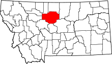 | |
| Towns | ||
| CDPs | ||
| Unincorporated communities | ||
| Ghost town | ||
| Indian reservation | ||
| Footnotes | ‡This populated place also has portions in an adjacent county or counties | |
This article is issued from Wikipedia - version of the 6/8/2015. The text is available under the Creative Commons Attribution/Share Alike but additional terms may apply for the media files.