List of mountains in Flathead County, Montana (M-Z)
This list is incomplete; you can help by expanding it.
There are at least 314 named mountains in Flathead County, Montana.
- Marmot Mountain, 47°41′24″N 113°28′57″W / 47.69000°N 113.48250°W, el. 8,238 feet (2,511 m)[1]
- Masonry Peak, 48°51′44″N 114°37′47″W / 48.86222°N 114.62972°W, el. 7,103 feet (2,165 m)[2]
- McGregor Peak, 48°02′49″N 114°48′19″W / 48.04694°N 114.80528°W, el. 5,210 feet (1,590 m)[3]
- McPartland Mountain, 48°41′26″N 113°51′49″W / 48.69056°N 113.86361°W, el. 8,159 feet (2,487 m)[4]
- Meadow Mountain, 47°49′10″N 113°22′14″W / 47.81944°N 113.37056°W, el. 7,077 feet (2,157 m)[5]
- Meadow Peak, 48°04′47″N 114°59′20″W / 48.07972°N 114.98889°W, el. 6,699 feet (2,042 m)[6]
- Medicine Grizzly Peak, 48°33′34″N 113°27′55″W / 48.55944°N 113.46528°W, el. 8,153 feet (2,485 m)[7]
- Mid Mountain, 47°49′41″N 113°17′54″W / 47.82806°N 113.29833°W, el. 7,375 feet (2,248 m)[8]
- Minaret Peak, 47°48′27″N 113°17′03″W / 47.80750°N 113.28417°W, el. 7,139 feet (2,176 m)[9]
- Moccasin Butte, 47°37′47″N 113°11′38″W / 47.62972°N 113.19389°W, el. 7,188 feet (2,191 m)[10]
- Moose Peak, 48°38′36″N 114°25′35″W / 48.64333°N 114.42639°W, el. 7,523 feet (2,293 m)[11]
- Moran Peak, 48°44′08″N 114°25′12″W / 48.73556°N 114.42000°W, el. 7,411 feet (2,259 m)[12]
- Mount Adams, 48°14′55″N 113°42′41″W / 48.24861°N 113.71139°W, el. 7,625 feet (2,324 m)[13]
- Mount Aeneas, 48°08′55″N 113°55′09″W / 48.14861°N 113.91917°W, el. 7,477 feet (2,279 m)[14]
- Mount Baptiste, 48°07′41″N 113°38′03″W / 48.12806°N 113.63417°W, el. 8,379 feet (2,554 m)[15]
- Mount Bradley, 48°10′08″N 113°27′33″W / 48.16889°N 113.45917°W, el. 7,339 feet (2,237 m)[16]
- Mount Brown, 48°38′18″N 113°49′04″W / 48.63833°N 113.81778°W, el. 8,438 feet (2,572 m)[17]
- Mount Cameahwait, 48°13′42″N 113°41′54″W / 48.22833°N 113.69833°W, el. 7,779 feet (2,371 m)[18]
- Mount Cannon, 48°41′33″N 113°46′27″W / 48.69250°N 113.77417°W, el. 8,829 feet (2,691 m)[19]
- Mount Carter, 48°53′32″N 114°04′39″W / 48.89222°N 114.07750°W, el. 9,829 feet (2,996 m)[20]
- Mount Custer, 48°58′49″N 114°03′29″W / 48.98028°N 114.05806°W, el. 8,802 feet (2,683 m)[21]
- Mount Despair, 48°23′56″N 113°25′54″W / 48.39889°N 113.43167°W, el. 8,543 feet (2,604 m)[22]
- Mount Doody, 48°25′48″N 113°34′33″W / 48.43000°N 113.57583°W, el. 8,651 feet (2,637 m)[23]
- Mount Furlong, 48°13′16″N 113°30′51″W / 48.22111°N 113.51417°W, el. 7,260 feet (2,210 m)[24]
- Mount Geduhn, 48°47′48″N 113°58′12″W / 48.79667°N 113.97000°W, el. 8,350 feet (2,550 m)[25]
- Mount Grant, 48°19′29″N 113°45′21″W / 48.32472°N 113.75583°W, el. 8,589 feet (2,618 m)[26]
- Mount Hefty, 48°59′51″N 114°34′25″W / 48.99750°N 114.57361°W, el. 7,467 feet (2,276 m)[27]
- Mount Jackson, 48°36′02″N 113°43′19″W / 48.60056°N 113.72194°W, el. 10,039 feet (3,060 m)[28]
- Mount Johns, 47°57′52″N 114°11′48″W / 47.96444°N 114.19667°W, el. 3,589 feet (1,094 m)[29]
- Mount Liebig, 48°18′29″N 113°43′58″W / 48.30806°N 113.73278°W, el. 8,015 feet (2,443 m)[30]
- Mount May, 47°59′29″N 113°00′54″W / 47.99139°N 113.01500°W, el. 6,975 feet (2,126 m)[31]
- Mount Murray, 48°16′32″N 113°46′01″W / 48.27556°N 113.76694°W, el. 7,093 feet (2,162 m)[32]
- Mount Oberlin, 48°42′16″N 113°44′09″W / 48.70444°N 113.73583°W, el. 8,064 feet (2,458 m)[33]
- Mount Orvis Evans, 48°00′49″N 113°51′57″W / 48.01361°N 113.86583°W, el. 7,434 feet (2,266 m)[34]
- Mount Peabody, 48°55′47″N 114°08′26″W / 48.92972°N 114.14056°W, el. 9,098 feet (2,773 m)[35]
- Mount Penrose, 48°24′34″N 113°50′14″W / 48.40944°N 113.83722°W, el. 7,818 feet (2,383 m)[36]
- Mount Phillips, 48°28′40″N 113°31′30″W / 48.47778°N 113.52500°W, el. 9,498 feet (2,895 m)[37]
- Mount Pinchot, 48°29′44″N 113°35′42″W / 48.49556°N 113.59500°W, el. 9,304 feet (2,836 m)[38]
- Mount Rockwell, 48°26′36″N 113°27′04″W / 48.44333°N 113.45111°W, el. 9,265 feet (2,824 m)[39]
- Mount Saint Nicholas, 48°23′30″N 113°33′01″W / 48.39167°N 113.55028°W, el. 9,304 feet (2,836 m)[40]
- Mount Shields, 48°16′32″N 113°30′57″W / 48.27556°N 113.51583°W, el. 7,129 feet (2,173 m)[41]
- Mount Stimson, 48°30′52″N 113°36′37″W / 48.51444°N 113.61028°W, el. 10,092 feet (3,076 m)[42]
- Mount Swaney, 48°24′32″N 114°46′42″W / 48.40889°N 114.77833°W, el. 6,319 feet (1,926 m)[43]
- Mount Thompson, 48°32′45″N 113°41′16″W / 48.54583°N 113.68778°W, el. 8,501 feet (2,591 m)[44]
- Mount Thompson-Seton, 48°52′13″N 114°39′06″W / 48.87028°N 114.65167°W, el. 7,815 feet (2,382 m)[45]
- Mount Vaught, 48°40′51″N 113°52′26″W / 48.68083°N 113.87389°W, el. 8,789 feet (2,679 m)[46]
- Mount Young, 48°48′02″N 114°37′49″W / 48.80056°N 114.63028°W, el. 7,280 feet (2,220 m)[47]
- Mud Lake Mountain, 47°38′32″N 113°18′49″W / 47.64222°N 113.31361°W, el. 6,339 feet (1,932 m)[48]
- Murr Peak, 47°57′19″N 114°51′15″W / 47.95528°N 114.85417°W, el. 6,762 feet (2,061 m)[49]
- Nahsukin Mountain, 48°50′28″N 113°59′22″W / 48.84111°N 113.98944°W, el. 8,172 feet (2,491 m)[50]
- Nasukoin Mountain, 48°47′43″N 114°34′42″W / 48.79528°N 114.57833°W, el. 8,048 feet (2,453 m)[51]
- Norris Mountain, 48°34′37″N 113°32′01″W / 48.57694°N 113.53361°W, el. 8,911 feet (2,716 m)[52]
- Numa Peak, 48°54′12″N 114°09′40″W / 48.90333°N 114.16111°W, el. 8,917 feet (2,718 m)[53]
- Nyack Mountain, 48°23′44″N 113°48′56″W / 48.39556°N 113.81556°W, el. 7,664 feet (2,336 m)[54]
- Oreamnos Peak, 47°41′38″N 113°34′04″W / 47.69389°N 113.56778°W, el. 7,940 feet (2,420 m)[55]
- Ousel Peak, 48°27′55″N 113°53′15″W / 48.46528°N 113.88750°W, el. 7,149 feet (2,179 m)[56]
- Owl Peak, 47°39′47″N 113°36′22″W / 47.66306°N 113.60611°W, el. 8,241 feet (2,512 m)[57]
- Pagoda Mountain, 47°41′40″N 113°15′14″W / 47.69444°N 113.25389°W, el. 8,041 feet (2,451 m)[58]
- Parke Peak, 48°56′44″N 114°14′21″W / 48.94556°N 114.23917°W, el. 8,940 feet (2,720 m)[59]
- Paul Bunyans Cabin, 48°44′28″N 113°56′12″W / 48.74111°N 113.93667°W, el. 8,432 feet (2,570 m)[60]
- Paul Mountain, 48°36′53″N 114°47′19″W / 48.61472°N 114.78861°W, el. 5,508 feet (1,679 m)[61]
- Pentagon Mountain, 47°55′39″N 113°07′29″W / 47.92750°N 113.12472°W, el. 8,852 feet (2,698 m)[62]
- Peril Peak, 48°27′23″N 113°35′25″W / 48.45639°N 113.59028°W, el. 8,651 feet (2,637 m)[63]
- Pilot Knob, 48°21′59″N 114°29′16″W / 48.36639°N 114.48778°W, el. 4,272 feet (1,302 m)[64]
- Pinehill, 47°57′22″N 114°52′33″W / 47.95611°N 114.87583°W, el. 6,398 feet (1,950 m)[65]
- Pivot Mountain, 47°53′39″N 113°11′40″W / 47.89417°N 113.19444°W, el. 7,395 feet (2,254 m)[66]
- Pleasant Valley Mountain, 48°12′30″N 114°44′52″W / 48.20833°N 114.74778°W, el. 5,695 feet (1,736 m)[67]
- Pot Mountain, 47°55′52″N 113°10′47″W / 47.93111°N 113.17972°W, el. 7,648 feet (2,331 m)[68]
- Prospector Mountain, 48°06′17″N 113°37′37″W / 48.10472°N 113.62694°W, el. 8,087 feet (2,465 m)[69]
- Puzzle Hills, 48°13′59″N 113°17′37″W / 48.23306°N 113.29361°W, el. 6,548 feet (1,996 m)[70]
- Pyramid Peak, 48°26′59″N 113°53′10″W / 48.44972°N 113.88611°W, el. 7,260 feet (2,210 m)[71]
- Rainbow Peak, 48°52′45″N 114°05′49″W / 48.87917°N 114.09694°W, el. 9,803 feet (2,988 m)[72]
- Rampage Mountain, 48°20′45″N 113°35′20″W / 48.34583°N 113.58889°W, el. 6,821 feet (2,079 m)[73]
- Rampart Mountain, 47°35′57″N 113°14′50″W / 47.59917°N 113.24722°W, el. 7,726 feet (2,355 m)[74]
- Razoredge Mountain, 48°33′24″N 113°30′58″W / 48.55667°N 113.51611°W, el. 8,569 feet (2,612 m)[75]
- Red Crow Mountain, 48°24′06″N 113°20′54″W / 48.40167°N 113.34833°W, el. 7,877 feet (2,401 m)[76]
- Red Plume Mountain, 48°08′59″N 113°18′19″W / 48.14972°N 113.30528°W, el. 7,940 feet (2,420 m)[77]
- Red Sky Mountain, 48°09′16″N 113°37′08″W / 48.15444°N 113.61889°W, el. 8,136 feet (2,480 m)[78]
- Reuter Peak, 48°54′42″N 114°12′06″W / 48.91167°N 114.20167°W, el. 8,750 feet (2,670 m)[79]
- Ringer Mountain, 48°01′16″N 113°07′11″W / 48.02111°N 113.11972°W, el. 7,628 feet (2,325 m)[80]
- Riverview Mountain, 48°22′01″N 113°36′58″W / 48.36694°N 113.61611°W, el. 6,381 feet (1,945 m)[81]
- Rogers Peak, 48°41′11″N 113°56′14″W / 48.68639°N 113.93722°W, el. 7,319 feet (2,231 m)[82]
- Running Rabbit Mountain, 48°15′32″N 113°32′27″W / 48.25889°N 113.54083°W, el. 7,684 feet (2,342 m)[83]
- Salmon Point, 47°37′14″N 113°24′29″W / 47.62056°N 113.40806°W, el. 6,922 feet (2,110 m)[84]
- Salt Mountain, 47°41′09″N 113°08′55″W / 47.68583°N 113.14861°W, el. 8,251 feet (2,515 m)[85]
- Salvage Mountain, 48°22′29″N 113°32′10″W / 48.37472°N 113.53611°W, el. 8,225 feet (2,507 m)[86]
- Sanders Mountain, 48°17′26″N 114°50′12″W / 48.29056°N 114.83667°W, el. 6,010 feet (1,830 m)[87]
- Sarah Peak, 47°46′55″N 113°26′58″W / 47.78194°N 113.44944°W, el. 7,349 feet (2,240 m)[88]
- Scalplock Mountain, 48°18′00″N 113°34′29″W / 48.30000°N 113.57472°W, el. 6,886 feet (2,099 m)[89]
- Sergeant Mountain, 47°53′43″N 113°19′51″W / 47.89528°N 113.33083°W, el. 7,454 feet (2,272 m)[90]
- Shadow Mountain, 47°54′49″N 113°10′17″W / 47.91361°N 113.17139°W, el. 7,634 feet (2,327 m)[91]
- Sheep Mountain, 48°20′30″N 113°28′15″W / 48.34167°N 113.47083°W, el. 8,530 feet (2,600 m)[92]
- Sheepherder Hill, 48°12′06″N 114°23′30″W / 48.20167°N 114.39167°W, el. 3,248 feet (990 m)[93]
- Silvertip Mountain, 47°47′04″N 113°15′02″W / 47.78444°N 113.25056°W, el. 8,855 feet (2,699 m)[94]
- Sixmile Mountain, 47°59′11″N 113°50′39″W / 47.98639°N 113.84417°W, el. 7,379 feet (2,249 m)[95]
- Skeleton Mountain, 48°22′18″N 113°21′43″W / 48.37167°N 113.36194°W, el. 7,470 feet (2,280 m)[96]
- Slick Rock, 47°44′47″N 113°25′34″W / 47.74639°N 113.42611°W, el. 6,739 feet (2,054 m)[97]
- Slideout Peak, 48°01′01″N 113°03′33″W / 48.01694°N 113.05917°W, el. 7,106 feet (2,166 m)[98]
- Slippery Bill Mountain, 48°11′26″N 113°15′58″W / 48.19056°N 113.26611°W, el. 7,421 feet (2,262 m)[99]
- Snow Peak, 47°40′55″N 113°27′02″W / 47.68194°N 113.45056°W, el. 8,156 feet (2,486 m)[100]
- Snowshed Mountain, 48°14′37″N 113°38′01″W / 48.24361°N 113.63361°W, el. 7,408 feet (2,258 m)[101]
- Snowslip Mountain, 48°15′45″N 113°30′57″W / 48.26250°N 113.51583°W, el. 7,228 feet (2,203 m)[102]
- Soakem Mountain, 48°01′28″N 113°20′06″W / 48.02444°N 113.33500°W, el. 7,487 feet (2,282 m)[103]
- Soldier Mountain, 47°57′20″N 113°37′18″W / 47.95556°N 113.62167°W, el. 6,578 feet (2,005 m)[104]
- Soldier Mountain, 48°20′27″N 113°30′03″W / 48.34083°N 113.50083°W, el. 7,306 feet (2,227 m)[105]
- Solitude Point, 47°38′58″N 113°20′56″W / 47.64944°N 113.34889°W, el. 4,737 feet (1,444 m)[106]
- Sphinx Peak, 47°38′13″N 113°08′40″W / 47.63694°N 113.14444°W, el. 8,501 feet (2,591 m)[107]
- Spotted Bear Mountain, 47°54′06″N 113°26′13″W / 47.90167°N 113.43694°W, el. 7,175 feet (2,187 m)[108]
- Spruce Point, 48°10′07″N 113°35′09″W / 48.16861°N 113.58583°W, el. 6,860 feet (2,090 m)[109]
- Spy Mountain, 48°00′50″N 113°25′29″W / 48.01389°N 113.42472°W, el. 7,103 feet (2,165 m)[110]
- Square Mountain, 48°12′44″N 113°18′34″W / 48.21222°N 113.30944°W, el. 6,988 feet (2,130 m)[111]
- Square Peak, 48°52′00″N 114°06′16″W / 48.86667°N 114.10444°W, el. 8,606 feet (2,623 m)[112]
- Stadium Peak, 47°40′44″N 113°30′03″W / 47.67889°N 113.50083°W, el. 8,402 feet (2,561 m)[113]
- Standard Peak, 48°32′31″N 114°14′49″W / 48.54194°N 114.24694°W, el. 7,188 feet (2,191 m)[114]
- Stanton Mountain, 48°39′36″N 113°53′39″W / 48.66000°N 113.89417°W, el. 7,756 feet (2,364 m)[115]
- Statuary Mountain, 48°23′30″N 113°29′30″W / 48.39167°N 113.49167°W, el. 8,192 feet (2,497 m)[116]
- Stony Hill, 47°55′14″N 113°35′19″W / 47.92056°N 113.58861°W, el. 7,136 feet (2,175 m)[117]
- Strawberry Mountain, 48°12′47″N 113°58′53″W / 48.21306°N 113.98139°W, el. 6,204 feet (1,891 m)[118]
- Sunday Mountain, 48°35′35″N 114°51′04″W / 48.59306°N 114.85111°W, el. 5,502 feet (1,677 m)[119]
- Swanberg Mountain, 48°28′17″N 114°01′22″W / 48.47139°N 114.02278°W, el. 3,550 feet (1,080 m)[120]
- Table Hill, 47°52′23″N 113°08′00″W / 47.87306°N 113.13333°W, el. 6,129 feet (1,868 m)[121]
- Table Mountain, 47°53′25″N 113°06′38″W / 47.89028°N 113.11056°W, el. 8,320 feet (2,540 m)[122]
- Tally Mountain, 48°23′14″N 114°35′04″W / 48.38722°N 114.58444°W, el. 5,331 feet (1,625 m)[123]
- Teakettle Mountain, 48°24′12″N 114°06′20″W / 48.40333°N 114.10556°W, el. 5,876 feet (1,791 m)[124]
- Tent Mountain, 48°09′21″N 113°12′14″W / 48.15583°N 113.20389°W, el. 7,188 feet (2,191 m)[125]
- Tepee Mountain, 47°52′33″N 114°49′43″W / 47.87583°N 114.82861°W, el. 6,568 feet (2,002 m)[126]
- Three Eagles Mountain, 48°06′44″N 113°52′13″W / 48.11222°N 113.87028°W, el. 7,447 feet (2,270 m)[127]
- Threesuns Mountain, 48°29′25″N 113°39′23″W / 48.49028°N 113.65639°W, el. 7,913 feet (2,412 m)[128]
- Threetops Mountain, 48°27′28″N 113°42′17″W / 48.45778°N 113.70472°W, el. 6,749 feet (2,057 m)[129]
- Thunderbolt Mountain, 47°51′56″N 113°40′34″W / 47.86556°N 113.67611°W, el. 7,762 feet (2,366 m)[130]
- Tinkham Mountain, 48°31′30″N 113°30′23″W / 48.52500°N 113.50639°W, el. 8,254 feet (2,516 m)[131]
- Tom Tom Mountain, 48°03′28″N 113°51′49″W / 48.05778°N 113.86361°W, el. 7,057 feet (2,151 m)[132]
- Tongue Mountain, 48°11′49″N 113°55′32″W / 48.19694°N 113.92556°W, el. 6,834 feet (2,083 m)[133]
- Tranquil Mountain, 47°49′48″N 113°37′44″W / 47.83000°N 113.62889°W, el. 7,218 feet (2,200 m)[134]
- Trapper Peak, 48°48′51″N 113°57′23″W / 48.81417°N 113.95639°W, el. 7,703 feet (2,348 m)[135]
- Triangle Peak, 48°25′17″N 113°53′09″W / 48.42139°N 113.88583°W, el. 7,526 feet (2,294 m)[136]
- Trilobite Peak, 47°58′52″N 113°08′55″W / 47.98111°N 113.14861°W, el. 8,163 feet (2,488 m)[137]
- Trinity Mountain, 48°07′02″N 113°23′28″W / 48.11722°N 113.39111°W, el. 7,579 feet (2,310 m)[138]
- Triple Divide Peak, 48°34′23″N 113°31′00″W / 48.57306°N 113.51667°W, el. 7,982 feet (2,433 m)[139]
- Tuchuck Mountain, 48°58′35″N 114°40′30″W / 48.97639°N 114.67500°W, el. 7,746 feet (2,361 m)[140]
- Turtlehead Mountain, 47°39′38″N 113°15′00″W / 47.66056°N 113.25000°W, el. 8,159 feet (2,487 m)[141]
- Twin Mountain, 48°04′44″N 113°27′55″W / 48.07889°N 113.46528°W, el. 7,329 feet (2,234 m)[142]
- Unawah Mountain, 48°10′15″N 113°38′56″W / 48.17083°N 113.64889°W, el. 7,854 feet (2,394 m)[143]
- Union Mountain, 48°03′21″N 113°16′41″W / 48.05583°N 113.27806°W, el. 7,615 feet (2,321 m)[144]
- Vance Hill, 48°46′15″N 114°18′02″W / 48.77083°N 114.30056°W, el. 3,730 feet (1,140 m)[145]
- Vigil Peak, 48°24′57″N 113°29′03″W / 48.41583°N 113.48417°W, el. 8,527 feet (2,599 m)[146]
- Vinegar Mountain, 48°10′48″N 113°30′47″W / 48.18000°N 113.51306°W, el. 7,103 feet (2,165 m)[147]
- Vulture Peak, 48°50′14″N 114°01′26″W / 48.83722°N 114.02389°W, el. 9,616 feet (2,931 m)[148]
- Walton Mountain, 48°34′32″N 113°43′58″W / 48.57556°N 113.73278°W, el. 8,917 feet (2,718 m)[149]
- Warrior Mountain, 47°49′14″N 113°39′44″W / 47.82056°N 113.66222°W, el. 7,766 feet (2,367 m)[150]
- Wedge Mountain, 48°53′27″N 114°29′59″W / 48.89083°N 114.49972°W, el. 6,499 feet (1,981 m)[151]
- Werner Peak, 48°34′38″N 114°25′59″W / 48.57722°N 114.43306°W, el. 6,939 feet (2,115 m)[152]
- Whale Buttes, 48°51′15″N 114°27′50″W / 48.85417°N 114.46389°W, el. 5,305 feet (1,617 m)[153]
- Whitcomb Peak, 47°59′01″N 113°21′21″W / 47.98361°N 113.35583°W, el. 7,221 feet (2,201 m)[154]
- Whitefish Mountain, 48°45′13″N 114°36′01″W / 48.75361°N 114.60028°W, el. 7,329 feet (2,234 m)[155]
- Wickiup Mountain, 48°01′49″N 113°48′25″W / 48.03028°N 113.80694°W, el. 7,270 feet (2,220 m)[156]
- Wild Bill Mountain, 48°00′34″N 114°27′51″W / 48.00944°N 114.46417°W, el. 6,007 feet (1,831 m)[157]
- Wild Horse Mountain, 48°03′22″N 114°23′25″W / 48.05611°N 114.39028°W, el. 5,190 feet (1,580 m)[158]
- Wildcat Mountain, 48°14′38″N 113°55′28″W / 48.24389°N 113.92444°W, el. 6,565 feet (2,001 m)[159]
- Wildrose Mountain, 48°05′28″N 113°20′50″W / 48.09111°N 113.34722°W, el. 7,247 feet (2,209 m)[160]
- Winter Points, 48°03′33″N 113°03′13″W / 48.05917°N 113.05361°W, el. 7,159 feet (2,182 m)[161]
- Wolf Gun Mountain, 48°44′58″N 113°59′41″W / 48.74944°N 113.99472°W, el. 7,949 feet (2,423 m)[162]
- Wolftail Mountain, 48°26′26″N 113°36′38″W / 48.44056°N 113.61056°W, el. 8,176 feet (2,492 m)[163]*
See also
Notes
- ↑ "Marmot Mountain". Geographic Names Information System. United States Geological Survey.
- ↑ "Masonry Peak". Geographic Names Information System. United States Geological Survey.
- ↑ "McGregor Peak". Geographic Names Information System. United States Geological Survey.
- ↑ "McPartland Mountain". Geographic Names Information System. United States Geological Survey.
- ↑ "Meadow Mountain". Geographic Names Information System. United States Geological Survey.
- ↑ "Meadow Peak". Geographic Names Information System. United States Geological Survey.
- ↑ "Medicine Grizzly Peak". Geographic Names Information System. United States Geological Survey.
- ↑ "Mid Mountain". Geographic Names Information System. United States Geological Survey.
- ↑ "Minaret Peak". Geographic Names Information System. United States Geological Survey.
- ↑ "Moccasin Butte". Geographic Names Information System. United States Geological Survey.
- ↑ "Moose Peak". Geographic Names Information System. United States Geological Survey.
- ↑ "Moran Peak". Geographic Names Information System. United States Geological Survey.
- ↑ "Mount Adams". Geographic Names Information System. United States Geological Survey.
- ↑ "Mount Aeneas". Geographic Names Information System. United States Geological Survey.
- ↑ "Mount Baptiste". Geographic Names Information System. United States Geological Survey.
- ↑ "Mount Bradley". Geographic Names Information System. United States Geological Survey.
- ↑ "Mount Brown". Geographic Names Information System. United States Geological Survey.
- ↑ "Mount Cameahwait". Geographic Names Information System. United States Geological Survey.
- ↑ "Mount Cannon". Geographic Names Information System. United States Geological Survey.
- ↑ "Mount Carter". Geographic Names Information System. United States Geological Survey.
- ↑ "Mount Custer". Geographic Names Information System. United States Geological Survey.
- ↑ "Mount Despair". Geographic Names Information System. United States Geological Survey.
- ↑ "Mount Doody". Geographic Names Information System. United States Geological Survey.
- ↑ "Mount Furlong". Geographic Names Information System. United States Geological Survey.
- ↑ "Mount Geduhn". Geographic Names Information System. United States Geological Survey.
- ↑ "Mount Grant". Geographic Names Information System. United States Geological Survey.
- ↑ "Mount Hefty". Geographic Names Information System. United States Geological Survey.
- ↑ "Mount Jackson". Geographic Names Information System. United States Geological Survey.
- ↑ "Mount Johns". Geographic Names Information System. United States Geological Survey.
- ↑ "Mount Liebig". Geographic Names Information System. United States Geological Survey.
- ↑ "Mount May". Geographic Names Information System. United States Geological Survey.
- ↑ "Mount Murray". Geographic Names Information System. United States Geological Survey.
- ↑ "Mount Oberlin". Geographic Names Information System. United States Geological Survey.
- ↑ "Mount Orvis Evans". Geographic Names Information System. United States Geological Survey.
- ↑ "Mount Peabody". Geographic Names Information System. United States Geological Survey.
- ↑ "Mount Penrose". Geographic Names Information System. United States Geological Survey.
- ↑ "Mount Phillips". Geographic Names Information System. United States Geological Survey.
- ↑ "Mount Pinchot". Geographic Names Information System. United States Geological Survey.
- ↑ "Mount Rockwell". Geographic Names Information System. United States Geological Survey.
- ↑ "Mount Saint Nicholas". Geographic Names Information System. United States Geological Survey.
- ↑ "Mount Shields". Geographic Names Information System. United States Geological Survey.
- ↑ "Mount Stimson". Geographic Names Information System. United States Geological Survey.
- ↑ "Mount Swaney". Geographic Names Information System. United States Geological Survey.
- ↑ "Mount Thompson". Geographic Names Information System. United States Geological Survey.
- ↑ "Mount Thompson-Seton". Geographic Names Information System. United States Geological Survey.
- ↑ "Mount Vaught". Geographic Names Information System. United States Geological Survey.
- ↑ "Mount Young". Geographic Names Information System. United States Geological Survey.
- ↑ "Mud Lake Mountain". Geographic Names Information System. United States Geological Survey.
- ↑ "Murr Peak". Geographic Names Information System. United States Geological Survey.
- ↑ "Nahsukin Mountain". Geographic Names Information System. United States Geological Survey.
- ↑ "Nasukoin Mountain". Geographic Names Information System. United States Geological Survey.
- ↑ "Norris Mountain". Geographic Names Information System. United States Geological Survey.
- ↑ "Numa Peak". Geographic Names Information System. United States Geological Survey.
- ↑ "Nyack Mountain". Geographic Names Information System. United States Geological Survey.
- ↑ "Oreamnos Peak". Geographic Names Information System. United States Geological Survey.
- ↑ "Ousel Peak". Geographic Names Information System. United States Geological Survey.
- ↑ "Owl Peak". Geographic Names Information System. United States Geological Survey.
- ↑ "Pagoda Mountain". Geographic Names Information System. United States Geological Survey.
- ↑ "Parke Peak". Geographic Names Information System. United States Geological Survey.
- ↑ "Paul Bunyans Cabin". Geographic Names Information System. United States Geological Survey.
- ↑ "Paul Mountain". Geographic Names Information System. United States Geological Survey.
- ↑ "Pentagon Mountain". Geographic Names Information System. United States Geological Survey.
- ↑ "Peril Peak". Geographic Names Information System. United States Geological Survey.
- ↑ "Pilot Knob". Geographic Names Information System. United States Geological Survey.
- ↑ "Pinehill". Geographic Names Information System. United States Geological Survey.
- ↑ "Pivot Mountain". Geographic Names Information System. United States Geological Survey.
- ↑ "Pleasant Valley Mountain". Geographic Names Information System. United States Geological Survey.
- ↑ "Pot Mountain". Geographic Names Information System. United States Geological Survey.
- ↑ "Prospector Mountain". Geographic Names Information System. United States Geological Survey.
- ↑ "Puzzle Hills". Geographic Names Information System. United States Geological Survey.
- ↑ "Pyramid Peak". Geographic Names Information System. United States Geological Survey.
- ↑ "Rainbow Peak". Geographic Names Information System. United States Geological Survey.
- ↑ "Rampage Mountain". Geographic Names Information System. United States Geological Survey.
- ↑ "Rampart Mountain". Geographic Names Information System. United States Geological Survey.
- ↑ "Razoredge Mountain". Geographic Names Information System. United States Geological Survey.
- ↑ "Red Crow Mountain". Geographic Names Information System. United States Geological Survey.
- ↑ "Red Plume Mountain". Geographic Names Information System. United States Geological Survey.
- ↑ "Red Sky Mountain". Geographic Names Information System. United States Geological Survey.
- ↑ "Reuter Peak". Geographic Names Information System. United States Geological Survey.
- ↑ "Ringer Mountain". Geographic Names Information System. United States Geological Survey.
- ↑ "Riverview Mountain". Geographic Names Information System. United States Geological Survey.
- ↑ "Rogers Peak". Geographic Names Information System. United States Geological Survey.
- ↑ "Running Rabbit Mountain". Geographic Names Information System. United States Geological Survey.
- ↑ "Salmon Point". Geographic Names Information System. United States Geological Survey.
- ↑ "Salt Mountain". Geographic Names Information System. United States Geological Survey.
- ↑ "Salvage Mountain". Geographic Names Information System. United States Geological Survey.
- ↑ "Sanders Mountain". Geographic Names Information System. United States Geological Survey.
- ↑ "Sarah Peak". Geographic Names Information System. United States Geological Survey.
- ↑ "Scalplock Mountain". Geographic Names Information System. United States Geological Survey.
- ↑ "Sergeant Mountain". Geographic Names Information System. United States Geological Survey.
- ↑ "Shadow Mountain". Geographic Names Information System. United States Geological Survey.
- ↑ "Sheep Mountain". Geographic Names Information System. United States Geological Survey.
- ↑ "Sheepherder Hill". Geographic Names Information System. United States Geological Survey.
- ↑ "Silvertip Mountain". Geographic Names Information System. United States Geological Survey.
- ↑ "Sixmile Mountain". Geographic Names Information System. United States Geological Survey.
- ↑ "Skeleton Mountain". Geographic Names Information System. United States Geological Survey.
- ↑ "Slick Rock". Geographic Names Information System. United States Geological Survey.
- ↑ "Slideout Peak". Geographic Names Information System. United States Geological Survey.
- ↑ "Slippery Bill Mountain". Geographic Names Information System. United States Geological Survey.
- ↑ "Snow Peak". Geographic Names Information System. United States Geological Survey.
- ↑ "Snowshed Mountain". Geographic Names Information System. United States Geological Survey.
- ↑ "Snowslip Mountain". Geographic Names Information System. United States Geological Survey.
- ↑ "Soakem Mountain". Geographic Names Information System. United States Geological Survey.
- ↑ "Soldier Mountain". Geographic Names Information System. United States Geological Survey.
- ↑ "Soldier Mountain". Geographic Names Information System. United States Geological Survey.
- ↑ "Solitude Point". Geographic Names Information System. United States Geological Survey.
- ↑ "Sphinx Peak". Geographic Names Information System. United States Geological Survey.
- ↑ "Spotted Bear Mountain". Geographic Names Information System. United States Geological Survey.
- ↑ "Spruce Point". Geographic Names Information System. United States Geological Survey.
- ↑ "Spy Mountain". Geographic Names Information System. United States Geological Survey.
- ↑ "Square Mountain". Geographic Names Information System. United States Geological Survey.
- ↑ "Square Peak". Geographic Names Information System. United States Geological Survey.
- ↑ "Stadium Peak". Geographic Names Information System. United States Geological Survey.
- ↑ "Standard Peak". Geographic Names Information System. United States Geological Survey.
- ↑ "Stanton Mountain". Geographic Names Information System. United States Geological Survey.
- ↑ "Statuary Mountain". Geographic Names Information System. United States Geological Survey.
- ↑ "Stony Hill". Geographic Names Information System. United States Geological Survey.
- ↑ "Strawberry Mountain". Geographic Names Information System. United States Geological Survey.
- ↑ "Sunday Mountain". Geographic Names Information System. United States Geological Survey.
- ↑ "Swanberg Mountain". Geographic Names Information System. United States Geological Survey.
- ↑ "Table Hill". Geographic Names Information System. United States Geological Survey.
- ↑ "Table Mountain". Geographic Names Information System. United States Geological Survey.
- ↑ "Tally Mountain". Geographic Names Information System. United States Geological Survey.
- ↑ "Teakettle Mountain". Geographic Names Information System. United States Geological Survey.
- ↑ "Tent Mountain". Geographic Names Information System. United States Geological Survey.
- ↑ "Tepee Mountain". Geographic Names Information System. United States Geological Survey.
- ↑ "Three Eagles Mountain". Geographic Names Information System. United States Geological Survey.
- ↑ "Threesuns Mountain". Geographic Names Information System. United States Geological Survey.
- ↑ "Threetops Mountain". Geographic Names Information System. United States Geological Survey.
- ↑ "Thunderbolt Mountain". Geographic Names Information System. United States Geological Survey.
- ↑ "Tinkham Mountain". Geographic Names Information System. United States Geological Survey.
- ↑ "Tom Tom Mountain". Geographic Names Information System. United States Geological Survey.
- ↑ "Tongue Mountain". Geographic Names Information System. United States Geological Survey.
- ↑ "Tranquil Mountain". Geographic Names Information System. United States Geological Survey.
- ↑ "Trapper Peak". Geographic Names Information System. United States Geological Survey.
- ↑ "Triangle Peak". Geographic Names Information System. United States Geological Survey.
- ↑ "Trilobite Peak". Geographic Names Information System. United States Geological Survey.
- ↑ "Trinity Mountain". Geographic Names Information System. United States Geological Survey.
- ↑ "Triple Divide Peak". Geographic Names Information System. United States Geological Survey.
- ↑ "Tuchuck Mountain". Geographic Names Information System. United States Geological Survey.
- ↑ "Turtlehead Mountain". Geographic Names Information System. United States Geological Survey.
- ↑ "Twin Mountain". Geographic Names Information System. United States Geological Survey.
- ↑ "Unawah Mountain". Geographic Names Information System. United States Geological Survey.
- ↑ "Union Mountain". Geographic Names Information System. United States Geological Survey.
- ↑ "Vance Hill". Geographic Names Information System. United States Geological Survey.
- ↑ "Vigil Peak". Geographic Names Information System. United States Geological Survey.
- ↑ "Vinegar Mountain". Geographic Names Information System. United States Geological Survey.
- ↑ "Vulture Peak". Geographic Names Information System. United States Geological Survey.
- ↑ "Walton Mountain". Geographic Names Information System. United States Geological Survey.
- ↑ "Warrior Mountain". Geographic Names Information System. United States Geological Survey.
- ↑ "Wedge Mountain". Geographic Names Information System. United States Geological Survey.
- ↑ "Werner Peak". Geographic Names Information System. United States Geological Survey.
- ↑ "Whale Buttes". Geographic Names Information System. United States Geological Survey.
- ↑ "Whitcomb Peak". Geographic Names Information System. United States Geological Survey.
- ↑ "Whitefish Mountain". Geographic Names Information System. United States Geological Survey.
- ↑ "Wickiup Mountain". Geographic Names Information System. United States Geological Survey.
- ↑ "Wild Bill Mountain". Geographic Names Information System. United States Geological Survey.
- ↑ "Wild Horse Mountain". Geographic Names Information System. United States Geological Survey.
- ↑ "Wildcat Mountain". Geographic Names Information System. United States Geological Survey.
- ↑ "Wildrose Mountain". Geographic Names Information System. United States Geological Survey.
- ↑ "Winter Points". Geographic Names Information System. United States Geological Survey.
- ↑ "Wolf Gun Mountain". Geographic Names Information System. United States Geological Survey.
- ↑ "Wolftail Mountain". Geographic Names Information System. United States Geological Survey.
Municipalities and communities of Flathead County, Montana, United States | ||
|---|---|---|
| Cities | 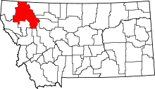 | |
| CDPs | ||
| Unincorporated communities | ||
| Indian reservation | ||
| Footnotes | ‡This populated place also has portions in an adjacent county or counties | |
This article is issued from Wikipedia - version of the 4/21/2013. The text is available under the Creative Commons Attribution/Share Alike but additional terms may apply for the media files.