List of mountains in Gallatin County, Montana
This list is incomplete; you can help by expanding it.
There are at least 100 named mountains in Gallatin County, Montana.
- Alex Lowe Peak, 45°25′38″N 111°00′52″W / 45.42722°N 111.01444°W, el. 10,020 feet (3,050 m)[1]
- Amber Butte, 45°25′00″N 111°02′03″W / 45.41667°N 111.03417°W, el. 8,806 feet (2,684 m)[2]
- Apex Point, 44°59′19″N 111°21′24″W / 44.98861°N 111.35667°W, el. 9,039 feet (2,755 m)[3]
- Avalanche Spire Rock, 45°25′50″N 111°11′23″W / 45.43056°N 111.18972°W, el. 6,732 feet (2,052 m)[4]
- Bald Peak, 44°43′32″N 111°20′54″W / 44.72556°N 111.34833°W, el. 10,180 feet (3,100 m)[5]
- Baldy Mountain, 45°46′03″N 110°56′38″W / 45.76750°N 110.94389°W, el. 8,829 feet (2,691 m)[6]
- Big Horn Peak, 45°04′01″N 111°03′00″W / 45.06694°N 111.05000°W, el. 9,934 feet (3,028 m)[7]
- Black Butte, 45°01′55″N 111°05′49″W / 45.03194°N 111.09694°W, el. 8,396 feet (2,559 m)[8]
- Blacktail Mountain, 46°01′47″N 111°04′34″W / 46.02972°N 111.07611°W, el. 8,369 feet (2,551 m)[9]
- Boat Mountain, 44°53′55″N 111°20′30″W / 44.89861°N 111.34167°W, el. 8,957 feet (2,730 m)[10]
- Bozeman Beacon, 45°41′35″N 110°59′01″W / 45.69306°N 110.98361°W, el. 5,646 feet (1,721 m)[11]
- Bridger Peak, 45°46′46″N 110°56′20″W / 45.77944°N 110.93889°W, el. 8,583 feet (2,616 m)[12]
- Burnt Top, 45°07′18″N 111°12′09″W / 45.12167°N 111.20250°W, el. 8,717 feet (2,657 m)[13]
- Cameron Point, 45°04′21″N 111°12′46″W / 45.07250°N 111.21278°W, el. 7,608 feet (2,319 m)[14]
- Canary Bird Peak, 45°06′21″N 111°03′36″W / 45.10583°N 111.06000°W, el. 7,933 feet (2,418 m)[15]
- Center Hill, 45°37′12″N 110°48′07″W / 45.62000°N 110.80194°W, el. 7,234 feet (2,205 m)[16]
- Chestnut Mountain, 45°36′20″N 110°52′56″W / 45.60556°N 110.88222°W, el. 7,667 feet (2,337 m)[17]
- Cinnamon Mountain, 45°07′49″N 111°16′06″W / 45.13028°N 111.26833°W, el. 9,226 feet (2,812 m)[18]
- Coffin Mountain, 44°46′39″N 111°21′49″W / 44.77750°N 111.36361°W, el. 9,967 feet (3,038 m)[19]
- Cone Peak, 44°55′41″N 111°11′27″W / 44.92806°N 111.19083°W, el. 9,662 feet (2,945 m)[20]
- Crown Butte, 45°04′00″N 111°08′12″W / 45.06667°N 111.13667°W, el. 8,035 feet (2,449 m)[21]
- Divide Peak, 45°24′12″N 110°58′30″W / 45.40333°N 110.97500°W, el. 10,033 feet (3,058 m)[22]
- Drinking Horse Mountain, 45°42′20″N 110°58′17″W / 45.70556°N 110.97139°W, el. 5,522 feet (1,683 m)[23]
- Eaglehead Mountain, 45°13′27″N 111°07′33″W / 45.22417°N 111.12583°W, el. 9,947 feet (3,032 m)[24]
- Eaglehead Mountain, 45°13′30″N 111°08′07″W / 45.22500°N 111.13528°W, el. 9,774 feet (2,979 m)[25]
- Elephant Mountain, 45°26′20″N 110°59′27″W / 45.43889°N 110.99083°W, el. 10,020 feet (3,050 m)[26]
- Flaming Arrow Rock, 45°42′30″N 110°58′03″W / 45.70833°N 110.96750°W, el. 4,980 feet (1,520 m)[27]
- Flanders Mountain, 45°26′23″N 110°56′42″W / 45.43972°N 110.94500°W, el. 9,862 feet (3,006 m)[28]
- Fortress Mountain, 45°10′03″N 111°06′44″W / 45.16750°N 111.11222°W, el. 9,613 feet (2,930 m)[29]
- Francham Mountain, 45°36′30″N 110°54′07″W / 45.60833°N 110.90194°W, el. 7,126 feet (2,172 m)[30]
- Fridley Peak, 45°23′04″N 110°56′19″W / 45.38444°N 110.93861°W, el. 10,082 feet (3,073 m)[31]
- Garnet Mountain, 45°25′36″N 111°12′23″W / 45.42667°N 111.20639°W, el. 8,202 feet (2,500 m)[32]
- Grassy Mountain, 45°49′21″N 110°51′42″W / 45.82250°N 110.86167°W, el. 7,605 feet (2,318 m)[33]
- Green Mountain, 45°41′53″N 110°52′27″W / 45.69806°N 110.87417°W, el. 6,834 feet (2,083 m)[34]
- Grouse Mountain, 45°05′47″N 111°10′33″W / 45.09639°N 111.17583°W, el. 8,409 feet (2,563 m)[35]
- Grouse Mountain, 46°02′36″N 110°54′18″W / 46.04333°N 110.90500°W, el. 7,461 feet (2,274 m)[36]
- Hardscrabble Peak, 45°54′52″N 110°58′57″W / 45.91444°N 110.98250°W, el. 9,527 feet (2,904 m)[37]
- Hatfield Mountain, 46°05′24″N 110°58′32″W / 46.09000°N 110.97556°W, el. 7,628 feet (2,325 m)[38]
- Horse Butte, 44°45′05″N 111°11′41″W / 44.75139°N 111.19472°W, el. 7,014 feet (2,138 m)[39]
- Horsethief Mountain, 46°01′59″N 111°00′13″W / 46.03306°N 111.00361°W, el. 6,959 feet (2,121 m)[40]
- Hyalite Peak, 45°22′52″N 110°57′40″W / 45.38111°N 110.96111°W, el. 10,295 feet (3,138 m)[41]
- Jumbo Mountain, 45°21′21″N 111°17′03″W / 45.35583°N 111.28417°W, el. 10,417 feet (3,175 m)[42]
- King Butte, 45°04′05″N 111°04′49″W / 45.06806°N 111.08028°W, el. 9,301 feet (2,835 m)[43]
- Kinor Peak, 45°26′48″N 111°00′51″W / 45.44667°N 111.01417°W, el. 8,976 feet (2,736 m)[44]
- Lava Butte, 45°03′12″N 111°06′20″W / 45.05333°N 111.10556°W, el. 7,880 feet (2,400 m)[45]
- Lemondrop, 45°12′10″N 111°13′28″W / 45.20278°N 111.22444°W, el. 7,339 feet (2,237 m)[46]
- Lincoln Mountain, 45°04′17″N 111°17′01″W / 45.07139°N 111.28361°W, el. 7,700 feet (2,300 m)[47]
- Lionhead, 44°43′43″N 111°19′25″W / 44.72861°N 111.32361°W, el. 9,554 feet (2,912 m)[48]
- Little Round Mountain, 45°56′33″N 111°14′12″W / 45.94250°N 111.23667°W, el. 5,564 feet (1,696 m)[49]
- Lombard Hill, 46°06′24″N 111°23′47″W / 46.10667°N 111.39639°W, el. 3,976 feet (1,212 m)[50]
- Lone Indian Peak, 45°09′06″N 111°09′35″W / 45.15167°N 111.15972°W, el. 8,602 feet (2,622 m)[51]
- Maid of the Mist Mountain, 45°24′59″N 110°58′12″W / 45.41639°N 110.97000°W, el. 9,570 feet (2,920 m)[52]
- Marble Point, 45°04′37″N 111°14′10″W / 45.07694°N 111.23611°W, el. 8,048 feet (2,453 m)[53]
- Monument Mountain, 44°58′38″N 111°10′22″W / 44.97722°N 111.17278°W, el. 10,056 feet (3,065 m)[54]
- Mount Baldy, 45°44′00″N 110°57′33″W / 45.73333°N 110.95917°W, el. 7,106 feet (2,166 m)[55]
- Mount Blackmore, 45°26′39″N 111°00′11″W / 45.44417°N 111.00306°W, el. 10,052 feet (3,064 m)[56]
- Mount Bole, 45°24′58″N 110°59′53″W / 45.41611°N 110.99806°W, el. 10,328 feet (3,148 m)[57]
- Mount Chipperfield, 45°19′38″N 111°21′16″W / 45.32722°N 111.35444°W, el. 9,938 feet (3,029 m)[58]
- Mount Chisholm, 45°24′18″N 110°55′48″W / 45.40500°N 110.93000°W, el. 9,744 feet (2,970 m)[59]
- Mount Ellis, 45°34′39″N 110°57′22″W / 45.57750°N 110.95611°W, el. 8,340 feet (2,540 m)[60]
- Mount Hebgen, 44°49′24″N 111°13′39″W / 44.82333°N 111.22750°W, el. 8,691 feet (2,649 m)[61]
- Naya Nuki Peak, 45°53′30″N 110°57′43″W / 45.89167°N 110.96194°W, el. 9,449 feet (2,880 m)[62]
- Nixon Peak, 45°52′38″N 110°48′58″W / 45.87722°N 110.81611°W, el. 6,834 feet (2,083 m)[63]
- Noon Mark, 45°30′07″N 111°12′36″W / 45.50194°N 111.21000°W, el. 7,487 feet (2,282 m)[64]
- Overlook Mountain, Montana, 45°24′20″N 110°56′33″W / 45.40556°N 110.94250°W, el. 10,243 feet (3,122 m)[65]
- Packsaddle Peak, 45°10′27″N 111°03′15″W / 45.17417°N 111.05417°W, el. 9,682 feet (2,951 m)[66]
- Palace Butte, 45°25′18″N 110°58′39″W / 45.42167°N 110.97750°W, el. 9,898 feet (3,017 m)[67]
- Palisade Mountain, 45°28′58″N 110°55′35″W / 45.48278°N 110.92639°W, el. 9,262 feet (2,823 m)[68]
- Pika Point, 44°59′01″N 111°18′36″W / 44.98361°N 111.31000°W, el. 9,501 feet (2,896 m)[69]
- Pine Butte, 45°38′56″N 111°13′37″W / 45.64889°N 111.22694°W, el. 5,207 feet (1,587 m)[70]
- Pomp Peak, 45°54′18″N 110°58′36″W / 45.90500°N 110.97667°W, el. 9,550 feet (2,910 m)[71]
- Ramshorn Peak, 45°09′20″N 111°05′35″W / 45.15556°N 111.09306°W, el. 10,213 feet (3,113 m)[72]
- Red Mountain, 44°56′48″N 111°09′32″W / 44.94667°N 111.15889°W, el. 9,977 feet (3,041 m)[73]
- Red Rock Mountain, 46°03′34″N 110°58′39″W / 46.05944°N 110.97750°W, el. 7,290 feet (2,220 m)[74]
- Redstreak Peak, 44°54′56″N 111°12′43″W / 44.91556°N 111.21194°W, el. 10,338 feet (3,151 m)[75]
- Ross Peak, 45°51′31″N 110°57′22″W / 45.85861°N 110.95611°W, el. 9,012 feet (2,747 m)[76]
- Round Mountain, 45°55′21″N 111°14′43″W / 45.92250°N 111.24528°W, el. 5,505 feet (1,678 m)[77]
- Ruby Mountain, 45°35′08″N 111°19′29″W / 45.58556°N 111.32472°W, el. 6,243 feet (1,903 m)[78]
- Rugged Mountain, location unknown, el. 8,386 feet (2,556 m)[79]
- Sacagawea Peak, 45°53′44″N 110°58′08″W / 45.89556°N 110.96889°W, el. 9,596 feet (2,925 m)[80]
- Saddle Peak, 45°47′37″N 110°56′12″W / 45.79361°N 110.93667°W, el. 9,134 feet (2,784 m)[81]
- Sage Peak, 44°55′50″N 111°14′45″W / 44.93056°N 111.24583°W, el. 10,462 feet (3,189 m)[82]
- Sandy Butte, 44°47′17″N 111°04′36″W / 44.78806°N 111.07667°W, el. 6,952 feet (2,119 m)[83]
- Sleeping Giant Mountain, 45°27′19″N 110°56′33″W / 45.45528°N 110.94250°W, el. 8,917 feet (2,718 m)[84]
- Snowslide Mountain, 44°57′34″N 111°10′29″W / 44.95944°N 111.17472°W, el. 10,016 feet (3,053 m)[85]
- Spire Rock, 45°26′25″N 111°10′55″W / 45.44028°N 111.18194°W, el. 6,378 feet (1,944 m)[86]
- Streamboat Mountain, 45°10′50″N 111°03′35″W / 45.18056°N 111.05972°W, el. 9,987 feet (3,044 m)[87]
- Storm Castle, 45°27′01″N 111°13′24″W / 45.45028°N 111.22333°W, el. 7,165 feet (2,184 m)[88]
- Sunshine Point, 45°04′26″N 111°10′50″W / 45.07389°N 111.18056°W, el. 8,209 feet (2,502 m)[89]
- Table Mountain, 46°05′13″N 111°06′54″W / 46.08694°N 111.11500°W, el. 5,285 feet (1,611 m)[90]
- Table Mountain, 45°19′56″N 111°15′12″W / 45.33222°N 111.25333°W, el. 9,833 feet (2,997 m)[91]
- Tepee Point, 44°54′24″N 111°08′20″W / 44.90667°N 111.13889°W, el. 9,409 feet (2,868 m)[92]
- The Mummy, 45°26′50″N 110°56′33″W / 45.44722°N 110.94250°W, el. 9,354 feet (2,851 m)[93]
- The Sentinel, 45°17′54″N 111°05′22″W / 45.29833°N 111.08944°W, el. 9,623 feet (2,933 m)[94]
- Timber Butte, 45°24′48″N 111°04′21″W / 45.41333°N 111.07250°W, el. 7,333 feet (2,235 m)[95]
- Twin Peaks, 45°09′54″N 111°04′59″W / 45.16500°N 111.08306°W, el. 10,059 feet (3,066 m)[96]
- Wheeler Mountain, 45°30′35″N 111°04′56″W / 45.50972°N 111.08222°W, el. 8,599 feet (2,621 m)[97]
- White Peak, 44°54′42″N 111°12′07″W / 44.91167°N 111.20194°W, el. 10,236 feet (3,120 m)[98]
- Wilson Peak, 45°19′37″N 111°19′32″W / 45.32694°N 111.32556°W, el. 10,495 feet (3,199 m)[99]
- Zade Mountain, 46°01′34″N 111°03′01″W / 46.02611°N 111.05028°W, el. 8,084 feet (2,464 m)[100]
See also
Notes
- ↑ "Alex Lowe Peak". Geographic Names Information System. United States Geological Survey.
- ↑ "Amber Butte". Geographic Names Information System. United States Geological Survey.
- ↑ "Apex Point". Geographic Names Information System. United States Geological Survey.
- ↑ "Avalanche Spire Rock". Geographic Names Information System. United States Geological Survey.
- ↑ "Bald Peak". Geographic Names Information System. United States Geological Survey.
- ↑ "Baldy Mountain". Geographic Names Information System. United States Geological Survey.
- ↑ "Big Horn Peak". Geographic Names Information System. United States Geological Survey.
- ↑ "Black Butte". Geographic Names Information System. United States Geological Survey.
- ↑ "Blacktail Mountain". Geographic Names Information System. United States Geological Survey.
- ↑ "Boat Mountain". Geographic Names Information System. United States Geological Survey.
- ↑ "Bozeman Beacon". Geographic Names Information System. United States Geological Survey.
- ↑ "Bridger Peak". Geographic Names Information System. United States Geological Survey.
- ↑ "Burnt Top". Geographic Names Information System. United States Geological Survey.
- ↑ "Cameron Point". Geographic Names Information System. United States Geological Survey.
- ↑ "Canary Bird Peak". Geographic Names Information System. United States Geological Survey.
- ↑ "Center Hill". Geographic Names Information System. United States Geological Survey.
- ↑ "Chestnut Mountain". Geographic Names Information System. United States Geological Survey.
- ↑ "Cinnamon Mountain". Geographic Names Information System. United States Geological Survey.
- ↑ "Coffin Mountain". Geographic Names Information System. United States Geological Survey.
- ↑ "Cone Peak". Geographic Names Information System. United States Geological Survey.
- ↑ "Crown Butte". Geographic Names Information System. United States Geological Survey.
- ↑ "Divide Peak". Geographic Names Information System. United States Geological Survey.
- ↑ "Drinking Horse Mountain". Geographic Names Information System. United States Geological Survey.
- ↑ "Eaglehead Mountain". Geographic Names Information System. United States Geological Survey.
- ↑ "Eaglehead Mountain". Geographic Names Information System. United States Geological Survey.
- ↑ "Elephant Mountain". Geographic Names Information System. United States Geological Survey.
- ↑ "Flaming Arrow Rock". Geographic Names Information System. United States Geological Survey.
- ↑ "Flanders Mountain". Geographic Names Information System. United States Geological Survey.
- ↑ "Fortress Mountain". Geographic Names Information System. United States Geological Survey.
- ↑ "Francham Mountain". Geographic Names Information System. United States Geological Survey.
- ↑ "Fridley Peak". Geographic Names Information System. United States Geological Survey.
- ↑ "Garnet Mountain". Geographic Names Information System. United States Geological Survey.
- ↑ "Grassy Mountain". Geographic Names Information System. United States Geological Survey.
- ↑ "Green Mountain". Geographic Names Information System. United States Geological Survey.
- ↑ "Grouse Mountain". Geographic Names Information System. United States Geological Survey.
- ↑ "Grouse Mountain". Geographic Names Information System. United States Geological Survey.
- ↑ "Hardscrabble Peak". Geographic Names Information System. United States Geological Survey.
- ↑ "Hatfield Mountain". Geographic Names Information System. United States Geological Survey.
- ↑ "Horse Butte". Geographic Names Information System. United States Geological Survey.
- ↑ "Horsethief Mountain". Geographic Names Information System. United States Geological Survey.
- ↑ "Hyalite Peak". Geographic Names Information System. United States Geological Survey.
- ↑ "Jumbo Mountain". Geographic Names Information System. United States Geological Survey.
- ↑ "King Butte". Geographic Names Information System. United States Geological Survey.
- ↑ "Kinor Peak". Geographic Names Information System. United States Geological Survey.
- ↑ "Lava Butte". Geographic Names Information System. United States Geological Survey.
- ↑ "Lemondrop". Geographic Names Information System. United States Geological Survey.
- ↑ "Lincoln Mountain". Geographic Names Information System. United States Geological Survey.
- ↑ "Lionhead". Geographic Names Information System. United States Geological Survey.
- ↑ "Little Round Mountain". Geographic Names Information System. United States Geological Survey.
- ↑ "Lombard Hill". Geographic Names Information System. United States Geological Survey.
- ↑ "Lone Indian Peak". Geographic Names Information System. United States Geological Survey.
- ↑ "Maid of the Mist Mountain". Geographic Names Information System. United States Geological Survey.
- ↑ "Marble Point". Geographic Names Information System. United States Geological Survey.
- ↑ "Monument Mountain". Geographic Names Information System. United States Geological Survey.
- ↑ "Mount Baldy". Geographic Names Information System. United States Geological Survey.
- ↑ "Mount Blackmore". Geographic Names Information System. United States Geological Survey.
- ↑ "Mount Bole". Geographic Names Information System. United States Geological Survey.
- ↑ "Mount Chipperfield". Geographic Names Information System. United States Geological Survey.
- ↑ "Mount Chisholm". Geographic Names Information System. United States Geological Survey.
- ↑ "Mount Ellis". Geographic Names Information System. United States Geological Survey.
- ↑ "Mount Hebgen". Geographic Names Information System. United States Geological Survey.
- ↑ "Naya Nuki Peak". Geographic Names Information System. United States Geological Survey.
- ↑ "Nixon Peak". Geographic Names Information System. United States Geological Survey.
- ↑ "Noon Mark". Geographic Names Information System. United States Geological Survey.
- ↑ "Overlook Mountain". Geographic Names Information System. United States Geological Survey.
- ↑ "Packsaddle Peak". Geographic Names Information System. United States Geological Survey.
- ↑ "Palace Butte". Geographic Names Information System. United States Geological Survey.
- ↑ "Palisade Mountain". Geographic Names Information System. United States Geological Survey.
- ↑ "Pika Point". Geographic Names Information System. United States Geological Survey.
- ↑ "Pine Butte". Geographic Names Information System. United States Geological Survey.
- ↑ "Pomp Peak". Geographic Names Information System. United States Geological Survey.
- ↑ "Ramshorn Peak". Geographic Names Information System. United States Geological Survey.
- ↑ "Red Mountain". Geographic Names Information System. United States Geological Survey.
- ↑ "Red Rock Mountain". Geographic Names Information System. United States Geological Survey.
- ↑ "Redstreak Peak". Geographic Names Information System. United States Geological Survey.
- ↑ "Ross Peak". Geographic Names Information System. United States Geological Survey.
- ↑ "Round Mountain". Geographic Names Information System. United States Geological Survey.
- ↑ "Ruby Mountain". Geographic Names Information System. United States Geological Survey.
- ↑ "Rugged Mountain". Geographic Names Information System. United States Geological Survey.
- ↑ "Sacagawea Peak". Geographic Names Information System. United States Geological Survey.
- ↑ "Saddle Peak". Geographic Names Information System. United States Geological Survey.
- ↑ "Sage Peak". Geographic Names Information System. United States Geological Survey.
- ↑ "Sandy Butte". Geographic Names Information System. United States Geological Survey.
- ↑ "Sleeping Giant Mountain". Geographic Names Information System. United States Geological Survey.
- ↑ "Snowslide Mountain". Geographic Names Information System. United States Geological Survey.
- ↑ "Spire Rock". Geographic Names Information System. United States Geological Survey.
- ↑ "Steamboat Mountain". Geographic Names Information System. United States Geological Survey.
- ↑ "Storm Castle". Geographic Names Information System. United States Geological Survey.
- ↑ "Sunshine Point". Geographic Names Information System. United States Geological Survey.
- ↑ "Table Mountain". Geographic Names Information System. United States Geological Survey.
- ↑ "Table Mountain". Geographic Names Information System. United States Geological Survey.
- ↑ "Tepee Point". Geographic Names Information System. United States Geological Survey.
- ↑ "The Mummy". Geographic Names Information System. United States Geological Survey.
- ↑ "The Sentinel". Geographic Names Information System. United States Geological Survey.
- ↑ "Timber Butte". Geographic Names Information System. United States Geological Survey.
- ↑ "Twin Peaks". Geographic Names Information System. United States Geological Survey.
- ↑ "Wheeler Mountain". Geographic Names Information System. United States Geological Survey.
- ↑ "White Peak". Geographic Names Information System. United States Geological Survey.
- ↑ "Wilson Peak". Geographic Names Information System. United States Geological Survey.
- ↑ "Zade Mountain". Geographic Names Information System. United States Geological Survey.
Municipalities and communities of Gallatin County, Montana, United States | ||
|---|---|---|
| Cities | 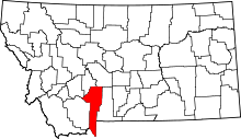 | |
| Towns | ||
| CDPs | ||
| Unincorporated communities | ||
| Footnotes | ‡This populated place also has portions in an adjacent county or counties | |
This article is issued from Wikipedia - version of the 2/2/2015. The text is available under the Creative Commons Attribution/Share Alike but additional terms may apply for the media files.