Lorraine Regional Natural Park
| Lorraine Regional Natural Park (Parc naturel régional de Lorraine) | |
| Protected Area | |
 | |
| Country | France |
|---|---|
| State | Meuse Meurthe-et-Moselle Moselle |
| Region | Lorraine |
| Coordinates | 48°53′23″N 6°02′39″E / 48.88967°N 6.04428°ECoordinates: 48°53′23″N 6°02′39″E / 48.88967°N 6.04428°E |
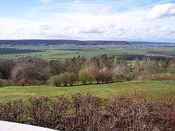
Lorraine Regional Natural Park (French: Parc naturel régional de Lorraine) is a protected area of pastoral countryside in the Lorraine region of northeastern France. The park covers a total area of 205,000 hectares (510,000 acres).[1] The parkland spreads between the cities of Metz and Nancy and spans three departments.[2]
Ancient ruins and modern monuments are common throughout the area.[2] The land was officially designated a regional natural park in 1974.[1]
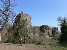
Ruins of the Château de Prény, original castle of the Dukes of Lorraine
Member communes
There are 193 communes within the parkland boundaries.[3][4]
- Albestroff • Ancy-sur-Moselle • Andilly • Ansauville • Apremont-la-Forêt • Arnaville • Assenoncourt • Avricourt • Azoudange
- Bar-le-Duc • Bayonville-sur-Mad • Beaumont • Belles-Forêts • Belleville • Beney-en-Woëvre • Bernecourt • Blanche-Église • Boncourt-sur-Meuse • Bonzée • Bouconville-sur-Madt • Boucq • Bouillonville • Bourdonnay • Broussey-Raulecourt • Bruley • Bruville • Buxières-sous-les-Côtes
- Chaillon • Chambley-Bussières • Charey • Château-Voué • Combres-sous-les-Côtes
- Dampvitoux • Desseling • Dieue-sur-Meuse • Dieulouard • Domèvre-en-Haye • Dommartin-la-Chaussée • Dommartin-la-Montagne • Dompierre-aux-Bois • Donnelay • Dornot
- Écrouves • Les Éparges • Essey-et-Maizerais • Euvezin • Euville
- Fénétrange • Fey-en-Haye • Flirey • Frémeréville-sous-les-Côtes • Fresnes-en-Woëvre • Fribourg
- Gelucourt • Génicourt-sur-Meuse • Geville • Gézoncourt • Girauvoisin • Givrycourt • Gondrexange • Gorze • Gravelotte • Griscourt • Grosrouvres • Guéblange-lès-Dieuze • Guermange
- Hagéville • Hamonville • Hampont • Han-sur-Meuse • Hannonville-sous-les-Côtes • Hannonville-Suzémont • Haraucourt-sur-Seille • Haudiomont • Herbeuville • Heudicourt-sous-les-Côtes
- Insviller
- Jaulny • Jezainville • Juvelize
- Lachaussée • Lacroix-sur-Meuse • Lagarde • Lagney • Lahayville •Lamorville • Laneuveville-derrière-Foug • Languimberg • Lidrezing • Limey-Remenauville • Lindre-Basse • Lironville • Loudrefing • Loupmont • Lucey
- Maidières • Maizières-lès-Vic • Mamey • Mandres-aux-Quatre-Tours • Manoncourt-en-Woëvre • Manonville • Marbache • Mars-la-Tour • Marsal • Martincourt • Mécrin • Ménil-la-Tour • Metz • Minorville • Mittersheim • Montauville • Morville-les-Vic • Mouilly • Moussey • Moyenvic • Mulcey • Munster
- Nancy • Nébing • Nonsard-Lamarche • Norroy-lès-Pont-à-Mousson • Novéant-sur-Moselle • Noviant-aux-Prés
- Obreck • Ommeray • Onville
- Pagney-derrière-Barine • Pagny-sur-Moselle • Pannes • Pont-sur-Meuse • Prény • Puxieux
- Rambucourt • Ranzières • Réchicourt-le-Château • Rembercourt-sur-Mad • Rening • Rezonville • Rhodes • Richecourt • Rogéville • Ronvaux • Rorbach-lès-Dieuze • Rosières-en-Haye • Rouvrois-sur-Meuse • Royaumeix • Rupt-en-Woëvre
- Saint-Julien-les-Gorze • Saint-Julien-sous-les-Côtes • Saint-Maurice-sous-les-Côtes • Saint-Médard • Saint-Remy-la-Calonne • Saizerais • Sanzey • Saulx-lès-Champlon • Seicheprey • Seuzey • Sommedieue • Sotzeling • Sponville
- Tarquimpol • Thiaucourt • Thillot • Tomblaine • Torcheville • Tremblecourt • Trésauvaux • Trondes • Tronville • Troyon
- Val-de-Bride • Valbois • Vandelainville • Varneville • Vaux • Vaux-les-Palameix • Vic-sur-Seille • Viéville-en-Haye • Vigneulles-lès-Hattonchâtel • Vignot • Vilcey-sur-Trey • Ville-sur-Yron • Villecey-sur-Mad • Villers-en-Haye • Villers-sous-Prény • Vionville
- Waville • Wuisse
- Xammes • Xivray-et-Marvoisin • Xonville
- Zarbeling • Zommange
See also
References
- 1 2 IUCN Commission on National Parks and Protected Areas (November 1990). 1990 United Nations list of national parks and protected areas. IUCN. p. 89. ISBN 978-2-8317-0032-8. Retrieved 26 August 2011.
- 1 2 Bailey, Rosemary (2007). National Geographic Traveler: France. Washington, DC: National Geographic Society. pp. 124–132. ISBN 978-1-4262-0027-4. Retrieved 26 August 2011.
- ↑ "Liste des 193 communes adhérentes du Parc" (in French). Parc naturel régional de Lorraine. 2011. Retrieved 20 October 2011.
- ↑ "Informations sur les villes, villages et mairies" (in French). Annuaire-mairie.fr. 2011. Retrieved 20 October 2011.
External links
- Official park website (French)
This article is issued from Wikipedia - version of the 10/4/2016. The text is available under the Creative Commons Attribution/Share Alike but additional terms may apply for the media files.