Lower Tenthill, Queensland
| Lower Tenthill Queensland | |||||||||||||
|---|---|---|---|---|---|---|---|---|---|---|---|---|---|
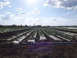 Crops along Gatton Clifton Road, 2014 | |||||||||||||
  Lower Tenthill | |||||||||||||
| Coordinates | 27°36′20″S 152°14′21″E / 27.60556°S 152.23917°ECoordinates: 27°36′20″S 152°14′21″E / 27.60556°S 152.23917°E | ||||||||||||
| Population | 333 (2011)[1] | ||||||||||||
| Postcode(s) | 4343 | ||||||||||||
| LGA(s) | Lockyer Valley Region | ||||||||||||
| State electorate(s) | Lockyer | ||||||||||||
| Federal Division(s) | Wright | ||||||||||||
| |||||||||||||
Lower Tenthill is a locality in the Lockyer Valley Region of South East Queensland, Australia. At the 2011 Australian Census the locality recorded a population of 333.[1]
Agriculture has developed along Tenthill Creek which also forms part of both the western and eastern boundary of Lower Tenthill. Lower Tenthill Weir on Tenthill Creek, has a storage capacity of 70 ML and is used for the purpose of recharging groundwater supplies.[2] The northern boundary follows Lockyer Creek. Two other creeks cross the area - Ma Ma Creek and Deep Creek.
Tent Hill Lower State School opened in 1873.[3]
References
- 1 2 Australian Bureau of Statistics (31 October 2012). "Lower Tenthill (State Suburb)". 2011 Census QuickStats. Retrieved 15 October 2014.
- ↑ "Strategic Asset Management Plan" (PDF). Seqwater. 18 May 2009. p. 26. Retrieved 15 October 2014.
- ↑ "Tent Hill Lower State School". Department of Education, Training and Employment. Retrieved 15 October 2014.
External links
 Media related to Tenthill, Queensland at Wikimedia Commons
This article is issued from Wikipedia - version of the 9/29/2016. The text is available under the Creative Commons Attribution/Share Alike but additional terms may apply for the media files.