Matotoka
| Matotoka | |
|---|---|
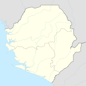  Matotoka Location in Sierra Leone | |
| Coordinates: 08°39′36″N 11°51′36″W / 8.66000°N 11.86000°WCoordinates: 08°39′36″N 11°51′36″W / 8.66000°N 11.86000°W | |
| Country |
 Sierra Leone Sierra Leone |
| Province | Northern Province |
| District | Tonkolili District |
| Time zone | GMT (UTC-5) |
Matotoka is a town in Tane Chiefdom, Tonkolili District in the Northern Province of Sierra Leone.[1]
Matotoka lies approximately 165 miles east of Freetown, on the highway linking Makeni to Kono District, and marks the point where the highway deteriorates to a rough track for the last 74 miles to Koidutown-Sefadu. [2] There are plans to improve this road with the help of a large grant from the African Development Bank.[3] A loan has been signed for the work as far as Yiye (a waterway at 8° 31' 00" N; 11° 21' 00" W).[4]
References
- ↑ "ACC takes the fight against corruption to youths in Matotoka". africayoungvoices.com. March 26, 2012. Retrieved May 1, 2012.
- ↑ "KONO people Cry For Good Road". November 9, 2011. Retrieved May 1, 2012.
- ↑ "African Development Bank Approves Funding for Matotoka–Sefadu Road". Retrieved May 4, 2012.
- ↑ "African Development Bank load signed for Matotoka–Yiye Road". Retrieved May 4, 2012.
This article is issued from Wikipedia - version of the 10/10/2012. The text is available under the Creative Commons Attribution/Share Alike but additional terms may apply for the media files.