Mellum
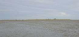 Mellum seen from the mudflat | |
| Geography | |
|---|---|
| Location | North Sea |
| Coordinates | 53°43′16″N 8°8′58″E / 53.72111°N 8.14944°ECoordinates: 53°43′16″N 8°8′58″E / 53.72111°N 8.14944°E |
| Area | 3 km2 (1.2 sq mi) |
| Length | 3 km (1.9 mi) |
| Width | 1.8 km (1.12 mi) |
| Highest elevation | 3 m (10 ft) |
| Administration | |
|
Germany | |
| Demographics | |
| Population | 0 |
Mellum is an uninhabited island lying southeast of Wangerooge, off the coastal settlements of Horumersiel and Schillig.
Mellum formed as an island off the end of the Butjadingen peninsula – which divides the outflows into the Wadden Sea of the Jade and Weser rivers – only at the end of the nineteenth century.[1] It is chiefly composed of dunes and tidal marshes. The influence of sea currents and winds is constantly altering the shape and position of the island, which in 2006 had a total surface area of approximately 750 hectares (1853 acres).
An important breeding and feeding ground for wild birds, Mellum is part of the Lower Saxony Wadden Sea National Park and a nature protection zone.[2] The island’s only house is today used during the summer months for wildlife observation and scientific research purposes only.
References
- ↑ "Mellum". Ecomare. Retrieved July 21, 2012.
- ↑ "Die Insel Mellum - Paradies zwischen Jade und Weser" (in German). Nationalpark wattenmeer. July 23, 2010. Retrieved July 21, 2012.
| West Frisian Islands (Netherlands) |
|  | |||||||||
|---|---|---|---|---|---|---|---|---|---|---|---|
| East Frisian Islands (Germany) |
| ||||||||||
| Heligoland Bight (Germany) | |||||||||||
| North Frisian Islands (Germany) |
| ||||||||||
| Danish Wadden Sea Islands (Denmark) |
| ||||||||||