Mount Wilbur (Montana)
| Mount Wilbur | |
|---|---|
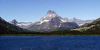 Mount Wilbur rises in the west, beyond Swiftcurrent Lake | |
| Highest point | |
| Elevation | 9,326 ft (2,843 m) [1] |
| Prominence | 2,136 ft (651 m) [1] |
| Parent peak | Mount Gould[1] |
| Listing | Mountains in Glacier County, Montana |
| Coordinates | 48°48′20″N 113°44′21″W / 48.80556°N 113.73917°WCoordinates: 48°48′20″N 113°44′21″W / 48.80556°N 113.73917°W [2] |
| Geography | |
  Mount Wilbur | |
| Parent range | Lewis Range |
| Topo map | USGS Many Glacier, MT |
| Climbing | |
| First ascent | 1923 (Norman Clyde)[1] |
| Easiest route | Climb, class 4 |
Mount Wilbur (9,326 feet (2,843 m)) is located in the Lewis Range, Glacier National Park in the U.S. state of Montana.[3] Plainly visible from the region of Many Glacier, the peak rises over 4,500 feet (1,372 m) above Swiftcurrent Lake and is a steep pyramid on three sides. The west slopes of the peak join to ridges along the continental divide. Much of the climbing routes are rated at class 4 to 5, with some only used once. The sedimentary rock of the mountains makes for often poor anchoring points and enhances the difficulty.[4] A cirque on the north slopes of the mountain shelter Iceberg Lake, a popular hiking destination from Many Glacier.[5]
See also
References
- 1 2 3 4 "Mount Wilbur, Montana". Peakbagger.com. Retrieved October 4, 2014.
- ↑ "Mount Wilbur". Geographic Names Information System. United States Geological Survey. Retrieved October 4, 2014.
- ↑ Many Glacier, MT (Map). TopoQwest (United States Geological Survey Maps). Retrieved October 4, 2014.
- ↑ "Mount Wilbur". SummitPost. Retrieved October 4, 2014.
- ↑ "Day Hikes" (pdf). Plan Your Visit. National Park Service. Retrieved October 4, 2014.
This article is issued from Wikipedia - version of the 12/23/2015. The text is available under the Creative Commons Attribution/Share Alike but additional terms may apply for the media files.