Shelburne, Nova Scotia (municipal district)
| Shelburne | ||
|---|---|---|
| Municipal district | ||
| ||
| Motto: From Ocean To Forest | ||
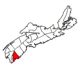 Location of Shelburne Municipal District | ||
| Coordinates: 43°51′00″N 65°16′58″W / 43.85°N 65.282778°W | ||
| Country |
 Canada Canada | |
| Province |
 Nova Scotia Nova Scotia | |
| County | Shelburne | |
| Founded | 1783 | |
| Incorporated | April 17, 1879 | |
| Electoral Districts Federal |
South Shore—St. Margaret's | |
| Provincial | Shelburne | |
| Government | ||
| • Type |
Council of the Municipality of the District of Shelburne | |
| • Warden | Roger Taylor | |
| Area[1] | ||
| • Land | 1,818.49 km2 (702.12 sq mi) | |
| Population (2011)[1][2] | ||
| • Total | 4,408 | |
| • Density | 2.4/km2 (6/sq mi) | |
| • Change 2006-11 |
 8.7% 8.7% | |
| Time zone | AST (UTC-4) | |
| • Summer (DST) | ADT (UTC-3) | |
| Dwellings | 2,641 | |
| Median Income* | $40,415 CDN | |
| Seat | Shelburne, Nova Scotia | |
| Website | municipalityof shelburne.ca | |
| ||
Municipality of the District of Shelburne is a municipal district comprising the eastern section of Shelburne County, Nova Scotia.
Demographics
|
| ||||||||||||||||||||||||||||||||||||||||||
| Ethnic Origin | Population | Pct (%) |
|---|---|---|
| Canadian | 2,285 | 56.5% |
| English | 1,135 | 28.1% |
| Scottish | 825 | 20.4% |
| Irish | 575 | 14.2% |
| German | 760 | 18.8% |
| French | 335 | 8.3% |
| Dutch (Netherlands) | 215 | 5.3% |
| Welsh | 145 | 3.6% |
| North American Indian | 115 | 2.8% |
| Métis | 115 | 2.8% |
Communities
The following communities are included within the Shelburne Municipal District:
- Allendale
- Arnold
- Atlantic
- Birchtown
- Blanche
- Carleton Village
- Churchover
- Clyde River
- East Green Harbour
- East Jordan
- East Sable River
- East Side of Ragged Island
- Granite Village
- Greenwood
- Gunning Cove
- Indian Fields
- Ingomar
- Jordan Bay
- Jordan Branch
- Jordan Falls
- Jordan Ferry
- Little Harbour
- Little Port L'Hebert
- Lockeport
- Lockeport Station
- Louis Head
- Lower Jordan Bay
- Lower Ohio
- Lower Sandy Point
- Lydgate
- McNutts Island
- Middle Ohio
- North East Harbour
- North West Harbour
- Ohio
- Osborne Harbour
- Pleasant Point
- Port Clyde
- Port L'Hebert
- Port Saxon
- Rockland
- Roseway
- Round Bay
- Sable River
- Sable River Station
- Sable River West
- Sandy Point
- Shelburne
- Upper Clyde River
- Upper Ohio
- Welshtown
- West Green Harbour
- West Middle Sable
- Western Head
Access routes
Highways and numbered routes that run through the district, including external routes that start or finish at the district limits:[5]


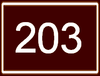
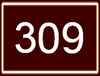
See also
References
- 1 2 3 2006 Statistics Canada Community Profile: Shelburne Municipal District, Nova Scotia
- ↑ Statistics Canada Population and dwelling counts, for Canada and census subdivisions (municipalities), 2006 and 2001 censuses - 100% data
- ↑ Statistics Canada: 1996, 2001, 2006 census
- ↑ 2006 Statistics Canada Census Topic-Based Tabulations: Shelburne Municipal District, Nova Scotia
- ↑ Atlantic Canada Back Road Atlas ISBN 978-1-55368-618-7 Page 89
 |
Argyle Municipal District | Digby Municipal District | | |
| Barrington Municipal District |  |
Region of Queens Municipality | ||
| ||||
 | ||||
| Atlantic Ocean |


| Counties | |
|---|---|
| Economic Regions | |
| Regional municipalities | |
| Municipal districts | |
| Towns | |
| Incorporated villages | |
| Lists | |
| |


Coordinates: 43°51′00″N 65°16′58″W / 43.85000°N 65.28278°W
This article is issued from Wikipedia - version of the 8/3/2016. The text is available under the Creative Commons Attribution/Share Alike but additional terms may apply for the media files.