Mường Tè District
| Mường Tè District Huyện Mường Tè | |
|---|---|
| Rural district | |
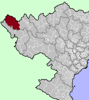 District location in northern Vietnam | |
| Country |
 Vietnam Vietnam |
| Region | Northwest |
| Province | Lai Châu |
| Capital | Mường Tè |
| Area | |
| • Total | 1,420 sq mi (3,679 km2) |
| Population (2003) | |
| • Total | 47,406 |
| Time zone | UTC + 7 (UTC+7) |
Mường Tè is a rural district of Lai Châu Province in the Northwest region of Vietnam. As of 2003, the district had a population of 47,406.[1] The district covers an area of 3,679 km². The district capital lies at Mường Tè.[1] Mường is equivalent to Mueang.
Geography
The district lies in the western part of Lai Châu Province, to the west of Sin Ho District.[2] Nậm Hàng commune in Mường Tè district is the site of the Lai Châu Dam, currently under construction.[3][4]
References
- 1 2 "Districts of Vietnam". Statoids. Retrieved March 13, 2009.
- ↑ Lai Chau Adminastrative Map (Map). Vietnam Bike Tours.
- ↑ The Saigon Times: Hai vấn đề nóng của thủy điện Lai Châu
- ↑ "Work on Vietnam's third largest hydropower plant begins". Thanh Nien. Intellasia News Services. 2011-01-14. Retrieved 2011-01-22.
Coordinates: 22°19′59″N 103°34′59″E / 22.333°N 103.583°E

This article is issued from Wikipedia - version of the 6/19/2015. The text is available under the Creative Commons Attribution/Share Alike but additional terms may apply for the media files.