North Carolina Highway 61
| ||||
|---|---|---|---|---|
 | ||||
| Route information | ||||
| Maintained by NCDOT | ||||
| Length: | 19.8 mi[1] (31.9 km) | |||
| Existed: | 1930 – present | |||
| Major junctions | ||||
| South end: |
 NC 62 near Alamance NC 62 near Alamance | |||
| North end: |
 NC 150 in Osceola NC 150 in Osceola | |||
| Location | ||||
| Counties: | Guilford | |||
| Highway system | ||||
| ||||


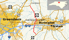
North Carolina Highway 61 (NC 61) is a primary state highway in the state of North Carolina. It serves as the main north–south highway in eastern Guilford County, connecting Whitsett and Gibsonville.
Route description
NC 61 is a two-lane rural highway from NC 62, located between Julian and Alamance, to NC 150, in Osceola. Serving primary as a farm-to-market, it connects the farms in eastern Guilford County with Whitsett and Gibsonville.
History
Established in 1930 as a new primary routing, it traversed from NC 109, in Thomasville, to NC 60, in Julian.[2] In 1936, NC 61 was extended northeast to US 70, near Whitsett. In 1940, NC 61 was truncated at its current southern terminus, its former routing south to Thomasville replaced by NC 62.[3] In 1961, NC 61 was extended on new primary routing north and onto NC 100 to Gibsonville; there, it continued north to its current northern terminus at NC 150, in Osceola.[4]
Junction list
The entire route is in Guilford County.
| Location | mi[1] | km | Destinations | Notes | |
|---|---|---|---|---|---|
| | 0.0 | 0.0 | NC 62 – Burlington, Julian, High Point | ||
| Whitsett | 6.3 | 10.1 |   I‑40 / I‑85 – Burlington, Greensboro I‑40 / I‑85 – Burlington, Greensboro | ||
| 7.4 | 11.9 |  US 70 (Burlington Road) – Burlington, Greensboro US 70 (Burlington Road) – Burlington, Greensboro | |||
| 8.2 | 13.2 |  NC 100 west NC 100 west | West end of NC 100 overlap | ||
| Gibsonville | 10.0 | 16.1 | NC 100 east (Main Street) – Elon | East end of NC 100 overlap | |
| Osceola | 19.8 | 31.9 | NC 150 (Burlington Road) – Brown Summit | ||
1.000 mi = 1.609 km; 1.000 km = 0.621 mi
| |||||
References
- 1 2 Google (October 26, 2014). "North Carolina Highway 61" (Map). Google Maps. Google. Retrieved October 26, 2014.
- ↑ State Highway System of North Carolina (PDF) (Map). Cartography by NCDOT. North Carolina Department of Transportation. 1930. Retrieved May 18, 2014.
- ↑ North Carolina Primary Highway System (PDF) (Map). Cartography by NCDOT. North Carolina Department of Transportation. 1940. Retrieved May 18, 2014.
- ↑ "Route Change (1961-12-07)" (PDF). North Carolina Department of Transportation. December 7, 1961. Retrieved October 26, 2014.