Nagongera
| Nagongera | |
|---|---|
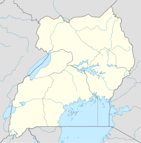  Nagongera Map of Uganda showing the location of Nagongera | |
| Coordinates: 00°46′12″N 34°01′34″E / 0.77000°N 34.02611°E | |
| Country |
 Uganda Uganda |
| Region | Eastern Uganda |
| District | Tororo District |
| Population (2011 Estimate) | |
| • Total | 11,800 |
| Time zone | EAT (UTC+3) |
Nagongera is a town in Tororo District, in the Eastern Region of Uganda.
Location
It is located approximately 20 kilometres (12 mi), west of Tororo, the location of the district headquarters.[1] This is about 45 kilometres (28 mi) southwest of Mbale, the largest city in Eastern Uganda.[2] Nagongera lies approximately 222 kilometres (138 mi), northeast of Kampala, the capital of Uganda and the largest city in that country.[3] The coordinates of the town are: 00°46'12.0"N, 34°01'34.0"E (Latitude:0.7700; Longitude:34.0261).[4]
Population
In 2002, the Uganda Bureau of Statistics (UBOS), estimated the population of Nagongera at 9,440. In 2010 UBOS estimated the mid-year population of the town at 11,600. In 2011, UBOS stimated Nagongera's population at 11,800.[5]
Points of interest
The following points of interest lie in or near Nagongera:
- The offices of Nagongera Town Council
- Nagongera Central Market
- Nagongera Train Station
- The town of Nagongera is the location of one of the campuses of Busitema University, a public university in Uganda.[6]
- Nagongera Health Centre IV[7]
Notable residents
- Paskar Owor, middle-distance runner
See also
References
- ↑ Globefeed.com (23 June 2016). "Distance between Tororo Market, Tororo District, Eastern Region, Uganda and Mirikiti Road, Nagongera, Tororo District, Eastern Region, Uganda". Globefeed.com. Retrieved 23 June 2016.
- ↑ Globefeed.com (23 June 2016). "Distance between Mirikiti Road, Nagongera, Tororo District, Eastern Region, Uganda and Mbale, Eastern Region, Uganda". Globefeed.com. Retrieved 23 June 2016.
- ↑ Globefeed.com (23 June 2016). "Distance between Uganda Post Office, Kampala Road, Kampala, Central Region, Uganda and Mirikiti Road, Nagongera, Tororo District, Eastern Region, Uganda". Globefeed.com. Retrieved 23 June 2016.
- ↑ Google (23 June 2016). "Location of Nagongera, Tororo District, Eastern Region, Uganda" (Map). Google Maps. Google. Retrieved 23 June 2016.
- ↑ UBOS (July 2011). "Estimated Population of Nagongera In 2002, 2010 and 2011" (PDF). Kampala: Uganda Bureau of Statistics (UBOS). Retrieved 23 June 2016.
- ↑ NatureUganda (21 February 2014). "NatureUganda Launches Busitema University Branch". NatureUganda.org. Retrieved 23 June 2016.
- ↑ Kate Zinszer; et al. (10 January 2014). "Determining health-care facility catchment areas in Uganda using data on malaria-related visits". Bulletin of the World Health Organization 2014: Volume:92. Geneva. pp. 178–186. Retrieved 23 June 2016.
External links
Capital: Tororo | ||
| Towns and villages | ||
| Geography |
| |
| Economy | ||
| Banking | ||
| Energy | ||
| Health |
| |
| Transport |
| |
| Notable landmarks | ||
| Education | ||
| Notable people | ||
Coordinates: 00°46′12″N 34°01′34″E / 0.77000°N 34.02611°E