Ngogwe
| Ngogwe | |
|---|---|
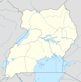  Ngogwe Map of Uganda showing the location of Ngogwe. | |
| Coordinates: 00°14′34″N 32°59′26″E / 0.24278°N 32.99056°ECoordinates: 00°14′34″N 32°59′26″E / 0.24278°N 32.99056°E | |
| Country |
 Uganda Uganda |
| Regions of Uganda | Central Region of Uganda |
| District | Buikwe District |
| County | Buikwe County |
| Constituency | Buikwe South |
| Government | |
| • Member of Parliament | Lulume Bayigga |
| Elevation | 1,200 m (3,900 ft) |
| Time zone | EAT (UTC+3) |
Ngogwe is a municipality in Buikwe District in the Central Region of Uganda.
Location
Ngogwe is approximately 18.5 kilometres (11.5 mi) south of Buikwe, the site of the district headquarters.[1] This is about 55 kilometres (34 mi) southeast of Kampala, the capital and largest city of Uganda.[2] The coordinates of Ngogwe are 0°14'34.0"N, 32°59'26.0"E (Latitude:0.242778; Longitude:32.990556).[3]
Points of interest
The following points of interest lie in or near Ngogwe:
- offices of Ngogwe Town Council
- Ngogwe Baskerville Secondary School
- Ngogwe central market
- source of River Sezibwa, located just north of the town
- Mukono–Kyetume–Katosi–Nyenga Road passing through the middle of town
See also
References
- ↑ GFC (20 July 2015). "Road Distance Between Buikwe And Ngogwe With Map". Globefeed.com (GFC). Retrieved 20 July 2015.
- ↑ GFC (20 July 2015). "Map Showing Kampala And Ngogwe With Route Marker". Globefeed.com (GFC). Retrieved 20 July 2015.
- ↑ Google (20 July 2015). "Location of Ngogwe at Google Maps" (Map). Google Maps. Google. Retrieved 20 July 2015.
Capital: Buikwe | |
| Towns and villages | |
| Geography | |
| Economy |
|
| Energy | |
| Notable landmarks |
|
| Health | |
| Transport | |
| Education | |
| Notable people | |
This article is issued from Wikipedia - version of the 8/1/2016. The text is available under the Creative Commons Attribution/Share Alike but additional terms may apply for the media files.