Nofei Nehemia
| Nofei Nehemia נופי נחמיה | |
|---|---|
  Nofei Nehemia | |
| Coordinates: 32°5′53.19″N 35°14′9.01″E / 32.0981083°N 35.2358361°ECoordinates: 32°5′53.19″N 35°14′9.01″E / 32.0981083°N 35.2358361°E | |
| District | Judea and Samaria Area |
| Council | Shomrom |
| Region | West Bank |
| Affiliation | Jewish |
| Founded | 2002 |
| Founded by | Amana |
| Name meaning | Nehemia's view |
| Website |
www |
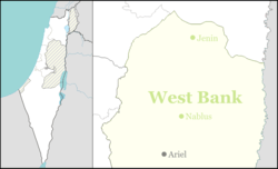
Nofei Nehemia (Hebrew: נוֹפֵי נְחֶמְיָה) is an Israeli outpost east of Ariel in the jurisdiction of the Shomron Regional Council in the northern West Bank. It is officially within the boundaries of Rechelim, a nearby Israeli settlement.[1] First established in 2002, it is situated adjacent to Rechelim on Route 60, between Kfar Tapuach and Eli.[2] The village also lies adjacent to the Palestinian towns of Iskaka and Yasuf. A few dozen families live on the outpost.
The outpost is named after Nehemia Ben Yehuda, the head of a family who own a crane company who have been very involved in assisting the establishment of settlements in the West Bank.
Nofei Nehemia, like all Israeli outposts, is illegal under Israeli law.[3] The Israeli government has pledged in the past to dismantle the outpost.[4] The international community views Israeli outposts as Israeli settlements and considers them also illegal under international law, but the Israeli government disputes this.[5]
References
- ↑ "PM: Ariel will remain under Israeli sovereignty". The Jerusalem Post. 9 January 2013.
- ↑ "Nofei Nehemia". Peace Now. Retrieved 29 March 2011.
- ↑ "IDF agrees to hold hearings for outpost residents". Haaretz. 9 June 2003.
- ↑ "'Hell no, we won't go,' vow settlers, but for now they choose legal challenges". Haaretz. 10 June 2003.
- ↑ "The Geneva Convention". BBC News. 10 December 2009. Retrieved 27 November 2010.