North Carolina Highway 210
| ||||
|---|---|---|---|---|
|
Route of NC 210 highlighted in red | ||||
| Route information | ||||
| Maintained by NCDOT | ||||
| Length: | 195 mi (314 km) | |||
| Existed: | 1931 – present | |||
| Major junctions | ||||
| North end: |
  US 70 Bus. in Smithfield US 70 Bus. in Smithfield | |||
| ||||
| South end: |
 US 17 near Sneads Ferry US 17 near Sneads Ferry | |||
| Location | ||||
| Counties: | Johnston, Harnett, Cumberland, Bladen, Pender, Onslow | |||
| Highway system | ||||
| ||||

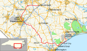


North Carolina Highway 210 (NC 210) is a 195-mile-long (314 km) North Carolina state highway that connects settlements in the Atlantic Coastal Plain region. Due to its meandering route NC 210 changes directional orientation three times, changing from east-west to north-south near Angier, changing from north-south to west-east near Moores Creek National Battlefield, and reversing west-east directions on Topsail Island. The route traverses through central Fayetteville and the Fort Bragg Army installation and crosses both Topsail Island access bridges over the Atlantic Intracoastal Waterway.
Junction list
| County | Location | mi | km | Destinations | Notes |
|---|---|---|---|---|---|
| Johnston | Smithfield | 0.00 | 0.00 | US 70 Bus. – Clayton, Goldsboro | NC 210 ends |
| McGee Crossroads | 0.05 | 0.080 |  I‑40 – Raleigh, Wilmington I‑40 – Raleigh, Wilmington | I-40 Exit 319 | |
| 0.08 | 0.13 |  NC 50 – Benson, Fuquay-Varina NC 50 – Benson, Fuquay-Varina | |||
| Harnett | Angier | 0.12 | 0.19 |  NC 55 – Fuquay-Varina, Erwin NC 55 – Fuquay-Varina, Erwin | |
| Lillington | 0.13 | 0.21 |    US 401 north / US 421 south / NC 27 east – Fuquay-Varina, Dunn, Benson US 401 north / US 421 south / NC 27 east – Fuquay-Varina, Dunn, Benson | North end of US 401 overlap, South end of US 421 overlap, East end of NC 27 overlap. | |
| 0.15 | 0.24 | US 421 north / US 401 south – Sanford, Fayetteville | North end of US 421 overlap, South end of US 401 overlap. | ||
| 0.17 | 0.27 | NC 27 west – Plainview | West end of NC 27 overlap. | ||
| Cumberland | Spring Lake | 0.21 | 0.34 |   NC 24 west / NC 87 north – Spout Springs NC 24 west / NC 87 north – Spout Springs | West end of NC 24 overlap, North end of NC 87 overlap. |
| 0.23 | 0.37 | NC 24 east / NC 87 south – Fayetteville | East end of NC 24 overlap, South end of NC 87 overlap. | ||
| Fayetteville | 0.24 | 0.39 | US 401 – Raeford, Lillington | ||
| 0.28 | 0.45 | NC 24 west – Spring Lake | West end of NC 24 overlap. | ||
| 0.31 | 0.50 |  I‑95 Bus. – Hope Mills, Dunn I‑95 Bus. – Hope Mills, Dunn | |||
| 0.35 | 0.56 | NC 24 east – Roseboro | East end of NC 24 overlap. | ||
| 0.35 | 0.56 |  I‑95 – Dunn, Smithfield, Lumberton I‑95 – Dunn, Smithfield, Lumberton | I-95 exit 49 | ||
| Stedman | 0.38 | 0.61 |  NC 53 east – Cedar Creek NC 53 east – Cedar Creek | East end of NC 53 overlap. | |
| | 0.41 | 0.66 |  NC 242 – Roseboro, Elizabethtown NC 242 – Roseboro, Elizabethtown | ||
| Bladen | | 0.44 | 0.71 |  US 701 – White Lake, Clinton US 701 – White Lake, Clinton | |
| | 0.47 | 0.76 |  NC 41 – White Lake, Tomahawk NC 41 – White Lake, Tomahawk | ||
| | 0.50 | 0.80 | NC 53 west – Kelly | West end of NC 53 overlap. | |
| | 0.53 | 0.85 | NC 53 east – Atkinson | East end of NC 53 overlap. | |
| | 0.57 | 0.92 |  NC 11 – Atkinson, Sandyfield NC 11 – Atkinson, Sandyfield | ||
| Pender | Currie | 1.15 | 1.85 | US 421 – Clinton, Wilmington | |
| Rocky Point | 1.23 | 1.98 |  NC 133 south – Castle Hayne NC 133 south – Castle Hayne | ||
| 1.25 | 2.01 |  US 117 – Castle Hayne, Burgaw US 117 – Castle Hayne, Burgaw | |||
| 1.47 | 2.37 | I‑40 – Burgaw, Wilmington | I-40 exit 408 | ||
| Hampstead | 1.55 | 2.49 | US 17 south – Wilmington | South end of US 17 overlap. | |
| Surf City | 1.67 | 2.69 | US 17 north – Jacksonville | North end of US 17 overlap. | |
| 1.98 | 3.19 | NC 50 north – Holly Ridge | North end of NC 50 overlap. | ||
| 2.05 | 3.30 | NC 50 south – Topsail Beach | South end of NC 50 overlap | ||
| Onslow | Sneads Ferry | 99.23 | 159.70 |  NC 172 – Hubert, Folkstone NC 172 – Hubert, Folkstone | |
| Dixon | 195.00 | 313.82 | US 17 – Jacksonville, Holly Ridge | NC 210 begins | |
1.000 mi = 1.609 km; 1.000 km = 0.621 mi
| |||||
See also
- North Carolina Bicycle Route 3 - Concurrent with NC 210 from Island Creek Road near Hampstead to Shaw Highway near Rocky Point
- North Carolina Bicycle Route 5 - Concurrent with NC 210 from Blueberry Road in Currie to Morgan Road in Still Bluff and again on its concurrency with NC 53
References
External links
-
 Media related to North Carolina Highway 210 at Wikimedia Commons
 - NCRoads.com: N.C. 210
This article is issued from Wikipedia - version of the 4/24/2016. The text is available under the Creative Commons Attribution/Share Alike but additional terms may apply for the media files.