Null Island
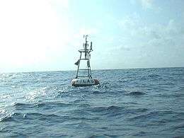 The weather buoy moored at the coordinates of Null Island | |
  Null Island | |
| Geography | |
|---|---|
| Coordinates | 0°N 0°E / 0°N 0°ECoordinates: 0°N 0°E / 0°N 0°E |
| Area | 1 m2 (11 sq ft) |
| Length | 1 m (3 ft) |
| Width | 1 m (3 ft) |
| Coastline | 4 m (13 ft) |
| Administration | |
| Demographics | |
| Population | 0 |
| Additional information | |
| This fictional island is a cartographical convenience only | |
Null Island is a fictional island in the Gulf of Guinea added to the Natural Earth public domain map dataset,[1] located where the equator crosses the prime meridian, at coordinates 0°N 0°E / 0°N 0°E.[2][3][4] Natural Earth describes the entity as a "1 meter square island" with "scale rank 100, indicating it should never be shown in mapping."[1] Although intended humorously, the fiction has a serious purpose and is used by mapping systems to trap errors.[3] Null Island was developed as an idea in 2011 or slightly earlier. Since then, numerous web pages have documented this fictional landmass's flag, geography, and history.[5]
In reality, a weather observation buoy, part of the PIRATA system, is moored at the supposed location of the island.[6]
See also
- Colonel Bleep, a 1957 cartoon that took place on the fictitious Zero Zero Island, at the same location as Null Island, where earth's equator meets the Greenwich Meridian.
References
- 1 2 Kurgan, Laura (2013). Close Up at a Distance: Mapping, Technology and Politics. New York: Zone Books. p. 157. ISBN 9781935408284.
- ↑ "Null Island". Retrieved 1 October 2013.
- 1 2 "Natural Earth version 1.3 release notes". 2011-01-31. Retrieved 1 October 2013.
- ↑ Hotz, Robert Lee (14 July 2016). "If You Can't Follow Directions, You'll End Up on Null Island". Wall Street Journal. Retrieved 14 July 2016.
- ↑ St. Onge, Tim. "The Geographical Oddity of Null Island". Library of Congress. Retrieved 13 May 2016.
- ↑ "Station 13010 - Soul". National Data Buoy Center. Retrieved 19 August 2014.