Ohio State Route 160
| ||||
|---|---|---|---|---|
 | ||||
| Route information | ||||
| Maintained by ODOT | ||||
| Length: | 38.82 mi[1] (62.47 km) | |||
| Existed: | 1926 – present | |||
| Major junctions | ||||
| South end: |
 SR 7 in Gallipolis SR 7 in Gallipolis | |||
| North end: |
 SR 93 in Hamden SR 93 in Hamden | |||
| Location | ||||
| Counties: | Gallia, Vinton | |||
| Highway system | ||||
| ||||


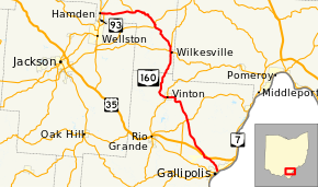
State Route 160 (SR 160) is a north–south state highway in the southeastern portion of the U.S. state of Ohio. Its southern terminus is at SR 7 in Gallipolis, and the route heads north. It meets U.S. Route 35 at an interchange with various collector and distributor ramps. SR 160 southbound bypasses the interchange on a 0.739-mile-long (1.189 km) road officially designated SR 160-A.[1] From there, the route passes through Vinton in northern Gallia County. Following an intersection with SR 32, the route heads in a more westerly direction until it meets and its northern terminus is at State Route 93 in Hamden.
History
1926
Original route certified; routed from 3 miles (4.8 km) north of Gallipolis to Hamden along the previous alignment of State Route 142 from 3 miles (4.8 km) north of Gallipolis to 4 miles (6.4 km) north of Radcliff, and along a previously unnumbered road from 4 miles (6.4 km) north of Radcliff to Hamden.[2]
1970
Extended south to Gallipolis along the previous alignment of U.S. Route 35 (which was the former State Route 11 before 1926).[2]
Major intersections
| County | Location | mi[1] | km | Destinations | Notes |
|---|---|---|---|---|---|
| Gallia | Gallipolis | 0.00 | 0.00 | SR 7 (Second Avenue) / Pine Street – Pomeroy, Crown City, Point Pleasant, W.Va. | |
| Gallipolis–Green township line | 2.31– 3.06 | 3.72– 4.92 |  .svg.png) US 35 / CR 6 (McCormick Road) – Charleston, W.Va., Jackson US 35 / CR 6 (McCormick Road) – Charleston, W.Va., Jackson | Interchange; no access from eastbound US 35; from southbound SR 160 to westbound US 35 | |
| Springfield Township | 3.57– 3.70 | 5.75– 5.95 | US 35 west – Jackson | Interchange; eastbound US 35 exit / westbound US 35 entrance only | |
| 9.68 | 15.58 |  SR 554 – Bidwell, Cheshire SR 554 – Bidwell, Cheshire | |||
| Vinton | 15.21 | 24.48 |  SR 325 north / Scenic Drive SR 325 north / Scenic Drive | Southern end of SR 325 concurrency | |
| 15.46 | 24.88 | SR 325 south / Van Buren Street | Northern end of SR 325 concurrency | ||
| Vinton | Wilkesville | 23.47 | 37.77 |  SR 124 east (Rutland Street) / Mill Street – Rutland, Pomeroy SR 124 east (Rutland Street) / Mill Street – Rutland, Pomeroy | Southern end of SR 124 concurrency |
| 23.74 | 38.21 | SR 124 west – Jackson | Northern end of SR 124 concurrency | ||
| Wilkesville Township | 24.46 | 39.36 |  SR 689 north – Albany SR 689 north – Albany | Southern terminus of SR 689 | |
| Vinton Township | 28.97 | 46.62 |  SR 32 (James A. Rhodes Appalachian Highway) – Wellston, Athens SR 32 (James A. Rhodes Appalachian Highway) – Wellston, Athens | ||
| Clinton Township | 33.71 | 54.25 |  SR 324 north – Dundas SR 324 north – Dundas | Southern terminus of SR 324 | |
| 38.21 | 61.49 |  SR 349 south – Wellston SR 349 south – Wellston | Northern terminus of SR 349 | ||
| Hamden | 38.82 | 62.47 | SR 93 (Main Street) – Wellston, McArthur | ||
1.000 mi = 1.609 km; 1.000 km = 0.621 mi
| |||||
References
- 1 2 3 "DESTAPE". Ohio Department of Transportation. July 3, 2014. Retrieved September 2, 2014.
- 1 2 Route 160 (The Unofficial Ohio State Highways Web Site) by John Simpson Archived December 29, 2004, at the Wayback Machine.