Ohio State Route 627
| ||||
|---|---|---|---|---|
 | ||||
| Route information | ||||
| Maintained by ODOT | ||||
| Length: | 4.76 mi[1] (7.66 km) | |||
| Existed: | 1987[2][3] – present | |||
| Major junctions | ||||
| West end: |
  US 30 / US 62 in Massillon US 30 / US 62 in Massillon | |||
| East end: |
 I-77 in Canton I-77 in Canton | |||
| Location | ||||
| Counties: | Stark | |||
| Highway system | ||||
| ||||


.svg.png)
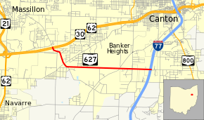
State Route 627 (SR 627) is an east–west state highway in the northeastern portion of the U.S. state of Ohio. SR 627's western terminus is at a diamond interchange with the US 30/US 62 freeway about 1.50 miles (2.41 km) southeast of Massillon. Its eastern terminus is also at a diamond interchange, this time with I-77 at its Exit 101 in far southern Canton.
Route description
The entire routing of SR 627 is situated in the western portion of Stark County. SR 627 is not a part of the National Highway System, a system of routes considered to be most important for the economy, mobility and defense of the nation.[4]
History
SR 627 was established in 1987 along the routing between the US 30/US 62 and I-77 freeways that it utilizes to this day. The route has not experienced any major changes to its alignment since its inception.[2][3]
Major intersections
The entire route is in Stark County.
| Location | mi[1] | km | Destinations | Notes | |
|---|---|---|---|---|---|
| Perry Township | 0.00 | 0.00 | US 30 / US 62 / Richville Drive – Canton, Wooster | Interchange | |
| Canton | 4.76 | 7.66 |  I-77 / CR 267 (Faircrest Street) – Akron, Marietta I-77 / CR 267 (Faircrest Street) – Akron, Marietta | Exit 101 (I-77) | |
| 1.000 mi = 1.609 km; 1.000 km = 0.621 mi | |||||
References
- 1 2 Ohio Department of Transportation. "Technical Services Straight Line Diagrams" (PDF). Retrieved 2013-07-10.
- 1 2 Official Ohio Highway Map (MrSID) (Map). Cartography by ODOT. Ohio Department of Transportation. 1985. Retrieved 2011-01-21.
- 1 2 Official Ohio Highway Map (MrSID) (Map). Cartography by ODOT. Ohio Department of Transportation. 1987. Retrieved 2011-01-21.
- ↑ National Highway System: Ohio (PDF) (Map). Federal Highway Administration. December 2003. Retrieved 2011-01-21.