Ohio State Route 725
| ||||
|---|---|---|---|---|
 | ||||
| Route information | ||||
| Maintained by ODOT | ||||
| Length: | 48.07 mi[1] (77.36 km) | |||
| Existed: | 1937[2][3] – present | |||
| Major junctions | ||||
| West end: |
 SR 44 at the Indiana state line SR 44 at the Indiana state line | |||
 US 127 in Camden US 127 in Camden I-75 in Miamisburg I-75 in Miamisburg I-675 in Miamisburg I-675 in Miamisburg | ||||
| East end: |
 US 42 near Spring Valley US 42 near Spring Valley | |||
| Location | ||||
| Counties: | Preble, Montgomery, Greene | |||
| Highway system | ||||
| ||||


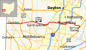
State Route 725 (SR 725) is an east–west state highway in the southwestern portion of the U.S. state of Ohio. Its western terminus is at the Indiana state line approximately 9 miles (14 km) west of Camden at the eastern terminus of Indiana State Road 44; and its eastern terminus is at US 42 just south of Spring Valley.[4]
Route description
The portion of SR 725 between Heincke Road and SR 741 in Miamisburg is designated as the "Marine Corporal Paul W. Zanowick II Memorial Highway",[5] in honor of a Miamisburg High School graduate, nicknamed "Rocky", who was killed in Nahre Saraj District, Helmand Province, Afghanistan on June 3, 2011.[6][7]
History
SR 725 was first commissioned in 1937 between the Indiana state line and SR 48 in Centerville.[2][3] In 1939, the route was extended east to US 42 in Spring Valley.[8][9] In 1965, the road between Miamisburg and I-75 was upgraded to a divided highway.[10][11] Between 1993 and 1995 the section of highway between I-675 and Centerville was upgraded to a divided highway.[12][13]
Major intersections
| County | Location | mi[1] | km | Destinations | Notes |
|---|---|---|---|---|---|
| Preble | Israel Township | 0.00 | 0.00 | SR 44 west – Liberty | Indiana state line |
| 2.80 | 4.51 |  SR 177 – Fairhaven, Hamilton SR 177 – Fairhaven, Hamilton | |||
| 4.01 | 6.45 |  SR 732 SR 732 | |||
| Camden | 8.78 | 14.13 | US 127 – Hamilton, Eaton | ||
| Gratis | 15.64 | 25.17 |  SR 503 (Adda Doty Street) SR 503 (Adda Doty Street) | ||
| 15.70 | 25.27 |  SR 122 (East Street) SR 122 (East Street) | |||
| Montgomery | Germantown | 25.13 | 40.44 |  SR 4 south / East Market Street – Middletown SR 4 south / East Market Street – Middletown | Western end of SR 4 concurrency |
| 26.68 | 42.94 | SR 4 north – Dayton | Eastern end of SR 4 concurrency | ||
| Miamisburg | 32.92– 33.15 | 52.98– 53.35 | I-75 – Cincinnati, Dayton | Exit 44 (I-75) | |
| 33.37 | 53.70 |  SR 741 (Springboro Pike) SR 741 (Springboro Pike) | |||
| 34.57– 34.72 | 55.64– 55.88 | I-675 – Cincinnati, Columbus | Exit 2 (I-675) | ||
| Centerville | 37.05 | 59.63 |  SR 48 south (South Main Street) / East Franklin Street SR 48 south (South Main Street) / East Franklin Street | Western end of SR 48 concurrency | |
| 38.12 | 61.35 | SR 48 north (Far Hills Avenue) to I-675 / West Alex Bell Road | Eastern end of SR 48 concurrency | ||
| Greene | Spring Valley | 48.07 | 77.36 | US 42 – Xenia, Lebanon | |
1.000 mi = 1.609 km; 1.000 km = 0.621 mi
| |||||
References
- 1 2 "DESTAPE". Ohio Department of Transportation. July 16, 2013. Retrieved August 19, 2014.
- 1 2 Ohio Department of Highways (1936). Official Highway Map of Ohio (MrSID) (Map). 1:760,320. Columbus: Ohio Department of Highways. OCLC 5673562. Retrieved September 2, 2013.
- 1 2 Ohio Department of Highways (1937). Official Highway Map of Ohio (MrSID) (Map). 1:633,600. Columbus: Ohio Department of Highways. OCLC 5673562, 16960304. Retrieved September 2, 2013.
- ↑ Google (February 9, 2014). "Ohio State Route 725" (Map). Google Maps. Google. Retrieved February 9, 2014.
- ↑ "5533.725 [Effective 6/3/2014] Marine Corporal Paul W. Zanowick II Memorial Highway.". Ohio Revised Code. LAW Writer. June 3, 2014. Retrieved April 21, 2014.
- ↑ Beyerlein, Tom; Wynn, Kelli (June 6, 2011). "Family, friends mourn the loss of Miamisburg Marine killed in Afghanistan". Dayton Daily News. Retrieved April 21, 2014.
- ↑ Staff (March 4, 2014). "Two local roads named for local fallen servicemen". WDTN. Retrieved April 21, 2014.
- ↑ Ohio Department of Highways (1938). Official Highway Map of Ohio (MrSID) (Map). 1:633,600. Columbus: Ohio Department of Highways. OCLC 5673562, 7453129. Retrieved September 2, 2013.
- ↑ Ohio Department of Highways (1939). Official Highway Map of Ohio (MrSID) (Map). 1:633,600. Columbus: Ohio Department of Highways. OCLC 5673562, 7408341. Retrieved September 2, 2013.
- ↑ Ohio Department of Highways (1964). Official Highway Map of Ohio (MrSID) (Map). Columbus: Ohio Department of Highways. OCLC 5673562, 7448791. Retrieved September 2, 2013.
- ↑ Ohio Department of Highways (1965). Official Highway Map of Ohio (MrSID) (Map). Columbus: Ohio Department of Highways. OCLC 5673562, 7438626, 28530064. Retrieved September 2, 2013.
- ↑ Ohio Department of Transportation (1993). Official Highway Map of Ohio (MrSID) (Map). Columbus: Ohio Department of Transportation. OCLC 5673562, 39739010. Retrieved September 2, 2013.
- ↑ Ohio Department of Transportation (November 1994). Official Highway Map of Ohio (MrSID) (Map). 1:696,960. Columbus: Ohio Department of Transportation. OCLC 5673562, 31884639. Retrieved September 2, 2013.