Pai River
| Pai River | |
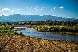 Pai River near Mae Hong Son | |
| Countries | Thailand, Burma |
|---|---|
| States | Mae Hong Son Province (Thailand), Kayah State (Burma) |
| Source | |
| - location | Daen Lao Range, Pai District, Mae Hong Son Province, Thailand |
| - elevation | 1,170 m (3,839 ft) |
| - coordinates | TH 19°27′0″N 98°29′20″E / 19.45000°N 98.48889°E |
| Mouth | Salween |
| - location | Punghsa-se, Kayah State, Burma |
| - elevation | 111 m (364 ft) |
| - coordinates | TH 19°08′45″N 97°32′40″E / 19.14583°N 97.54444°ECoordinates: TH 19°08′45″N 97°32′40″E / 19.14583°N 97.54444°E |
| Length | 180 km (112 mi) |
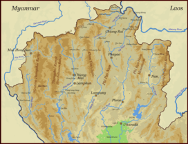 Map of the Thai highlands | |
The Pai River (Thai: แม่น้ำปาย, rtgs: Maenam Pai, Thai pronunciation: [mɛ̂ːnáːm paːj]) originates in the mountains of the Daen Lao Range, Pai District, Mae Hong Son Province, Thailand. The river flows first in a north-south direction and then in an east-west direction down to Mueang Mae Hong Son District and across the Thai/Burmese border. The river tributes the Salween River in Kayah State, Burma. It is 180 kilometres (110 mi) long.
Pai River is popular for whitewater rafting.[1] Rapids on the river vary from class I to class V on the International Scale of River Difficulty and everything in between. The Pai River offers a scenic view of mountain forest and many choose to camp along the quiet river banks.
See also
References
- ↑ "Rafting Along the Pai River". Tourism Thailand. Tourism Authority of Thailand (TAT). Retrieved 16 Mar 2015.
External links
- Pai River in Mae Hong Son
- A New Cyprinid Fish, Hampala salweenensis, from the Mae Pai River
- Huai Nam Dang National Park
This article is issued from Wikipedia - version of the 7/3/2016. The text is available under the Creative Commons Attribution/Share Alike but additional terms may apply for the media files.