Palpa District
| Pālpā Jillā पाल्पा जिल्ला | |
|---|---|
| District | |
|
The District headquarters Tansen. | |
 Location of Palpa | |
| Country | Nepal |
| Region | Western (Pashchimanchal) |
| Zone | Lumbini |
| Headquarters | Tansen |
| Area | |
| • Total | 1,373 km2 (530 sq mi) |
| Population (2011) | |
| • Total | 261,180 |
| • Density | 190/km2 (490/sq mi) |
| Time zone | NPT (UTC+5:45) |
| Website | Official Website |
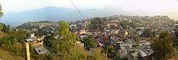
Palpa District (Nepali: पाल्पा जिल्ला Listen , a part of Province No. 5, is one of the seventy-five districts of Nepal, a landlocked country of South Asia. The district, with Tansen as its headquarters, covers an area of 1,373 km² and has a population (2011) of 261,180.[1]
Geography and Climate
| Climate Zone[2] | Elevation Range | % of Area |
|---|---|---|
| Lower Tropical | below 300 meters (1,000 ft) | 0.3% |
| Upper Tropical | 300 to 1,000 meters 1,000 to 3,300 ft. |
51.3% |
| Subtropical | 1,000 to 2,000 meters 3,300 to 6,600 ft. |
47.3% |
Municipalities and VDCs

Map of Palpa District
Major Rivers
- Kali Gandaki River
- Tinau River
- Ridi River
- Purwa River
- Jhumsa River
- Dovan River
Major Lakes
- Satyawati Lake (1400m above sea level)
- Pravas Lake
- Sita Kunda
Places of Attraction
- Argeli Palace was constructed by Juddha Shamsher and is considered a beautiful palace.
- Forts like Kalika fort, Nuwakot fort, Bakumgadi Fort are historic place of attraction
- Mahamritunjaya Statue of Lord Shiva situated at Barangdi which is the biggest in asia among metal statue of Lord Shiva
- Rambha Devi Temple is one of the famous and religious place 31 km east of Tansen in Tahu VDC.
- Ramdi is a religious place in the bank of Kali Gandaki River. On the 1st of Baisakh there is a festival in this area.
- Ranighat Palace (Ranimahal) is also called Tajmahal of Nepal due to similar stories behind the construction of this palace. It was constructed by General Khadka for her wife Tejkumari in 1893 AD.
- Rishikesh Complex of Ruru Kshetra Hindu pilgrimage and cremation site
- Rishikesh Temple was built by the King Manimukunda Sen. According to Hindu mythology, this is the place where some part of body of Satidevei was cremated. It is famous for festival which occurs in 1st of Magh month when hidus come to take bath in Kali Gandaki River.
- Shrinagar Hill is spot for viewing high Himalayas. Dhawalagiri, Tukuche, Nilgiri, Annapurana,Himchuli and other mountains can be viewed from this place.
- Tansen is a historic city with palaces, temples, stupas and historic architecture.
- Vhairabsthan Temple is a Shiva temple with huge trident, believed to be largest in Asia.
Trivia
People have a saying that it looks similar to Nepal in term of its geographical borders.
See also
References
- ↑ "2011 Nepal census (National Report)" (PDF). Central Bureau of Statistics. Government of Nepal. Retrieved November 2012. Check date values in:
|access-date=(help) - ↑ The Map of Potential Vegetation of Nepal - a forestry/agroecological/biodiversity classification system (PDF), . Forest & Landscape Development and Environment Series 2-2005 and CFC-TIS Document Series No.110., 2005, ISBN 87-7903-210-9, retrieved Nov 22, 2013 horizontal tab character in
|series=at position 91 (help)
- "Districts of Nepal". Statoids.
External links
Coordinates: 27°52′0″N 83°33′0″E / 27.86667°N 83.55000°E
 |
Wikimedia Commons has media related to Palpa District. |
This article is issued from Wikipedia - version of the 11/26/2016. The text is available under the Creative Commons Attribution/Share Alike but additional terms may apply for the media files.