Pirihueico Lake
| Pirihueico Lake Lago Pirihueico | |
|---|---|
 | |
| Location | Panguipulli Commune, Valdivia Province, Los Ríos Region, Chile |
| Coordinates | 39°55′48″S 71°47′25″W / 39.93000°S 71.79028°WCoordinates: 39°55′48″S 71°47′25″W / 39.93000°S 71.79028°W |
| Type | Glacial |
| Primary inflows | Huahum River |
| Primary outflows | Fui River |
| Basin countries | Chile, Argentina |
| Surface area | 40 km² [1] |
| Settlements | Puerto Fuy, Puerto Pirihueico |
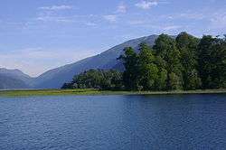
Pirihueico Lake (Spanish: Lago Pirihueico, Spanish pronunciation: [piɾiˈweiko] Pronounced: /piriˈweɪkoʊ/ PEE-ree-WAY-koh) is one of Seven Lakes in Panguipulli Commune, southern Chile. The lake is of glacial origin and it is enclosed mountains of the Andes. It is located in a geological fault that includes Panguipulli Lake and Lácar Lake in Argentina. The lake is drained by Fui River. Pirihueico Lake is used as a waterway due to its elonged shape. It is used mostly by vehicles traveling to or from Argentina by the nearby Huahum Pass. For that reason there is a ferry operating between Puerto Fuy and Puerto Pirihueico in the western respectively eastern extreme of the lake.
References
- ↑ Errázuriz, Ana María (1998). Manual de geografía de Chile.
External links
 Media related to Pirihueico Lake at Wikimedia Commons
This article is issued from Wikipedia - version of the 9/4/2015. The text is available under the Creative Commons Attribution/Share Alike but additional terms may apply for the media files.