Piscataway Creek
| Piscataway Creek | |
| Creek | |
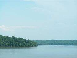 Mouth of Piscataway Creek, as seen from across the Potomac River | |
| Country | United States |
|---|---|
| State | Maryland |
| District | Prince George's County |
| Tributaries | |
| - right | Tinkers Creek |
| Source | |
| - location | Joint Base Andrews Naval Air Facility |
| - elevation | 226 ft (69 m) |
| - coordinates | 38°47′37″N 76°52′7″W / 38.79361°N 76.86861°W |
| Mouth | Potomac River |
| - location | Fort Washington Park |
| - elevation | 0 ft (0 m) |
| - coordinates | 38°42′37″N 77°2′24″W / 38.71028°N 77.04000°WCoordinates: 38°42′37″N 77°2′24″W / 38.71028°N 77.04000°W |
Piscataway Creek is an 18.6-mile-long (29.9 km)[1] tributary of the Potomac River in Prince George's County, Maryland. The creek is a tidal arm of the Potomac for its final 2.5 miles (4.0 km), entering the Potomac at Fort Washington Park. Tinkers Creek is a tributary to Piscataway Creek, converging from the north 4.5 miles (7.2 km) upstream of the mouth of the Piscataway.[1] The United States Geological Survey records two variant names for Piscataway Creek: Pascattawaye Creek and Puscattuway Creeke.[2]
The Fort Washington Light was built to provide guidance for mariners entering Piscataway Creek from the Potomac River.
See also
References
- 1 2 U.S. Geological Survey. National Hydrography Dataset high-resolution flowline data. The National Map, accessed August 15, 2011
- ↑ "Piscataway Creek". Geographic Names Information System. United States Geological Survey. Retrieved June 3, 2011.
External links
- U.S. Geological Survey water data for Piscataway Creek at Piscataway, Maryland
- NOAA nautical chart 12289
- National Park Service – Piscataway Park
This article is issued from Wikipedia - version of the 9/11/2016. The text is available under the Creative Commons Attribution/Share Alike but additional terms may apply for the media files.