Port Honduras Marine Reserve
| Port Honduras Marine Reserve | |
|---|---|
|
IUCN category IV (habitat/species management area) | |
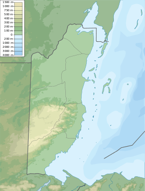  Map of Belize | |
| Location | Gulf of Honduras, Belize |
| Nearest city | Punta Gorda[1] |
| Coordinates | 16°12′11″N 88°38′02″W / 16.203°N 88.634°WCoordinates: 16°12′11″N 88°38′02″W / 16.203°N 88.634°W[2] |
| Area | 40,470 hectares (100,000 acres) |
| Established | January 2000 |
| Governing body |
|
Port Honduras Marine Reserve is a national protected marine reserve in the Toledo district of Belize. It was established in January 2000,[1] and covers 40,470 hectares (100,000 acres) of mangrove and coastal ecosystems. It encompasses over one hundred small, mangrove-fringed cayes, benthic habitats comprising soft-bottom seagrass beds and fringing reefs.[3]
The reserve is co-managemened by the community-based Toledo Institute for Development and Environment.[3] It is divided into two zones: a general use zone,[4] and a conservation zone.[5]
References
- 1 2 Belize Tourism Board. "Port of Honduras Marine Reserve". Travel Belize. Retrieved 3 September 2011.
- ↑ "Port Honduras Marine Reserve". protectedplanet.net.
- 1 2 Toledo Institute for Development and Environment. "Port Honduras Marine Reserve". Retrieved 3 August 2011.
- ↑ Belize Tropical Forest Studies (2010). "Port Honduras (General Use)". Biodiversity and Environmental Resource Data System.
- ↑ Belize Tropical Forest Studies (2010). "Port Honduras (Conservation Zone)". Biodiversity and Environmental Resource Data System.
This article is issued from Wikipedia - version of the 11/19/2016. The text is available under the Creative Commons Attribution/Share Alike but additional terms may apply for the media files.