Qardaha District
| Qardaha District منطقة القرداحة | |
|---|---|
| District | |
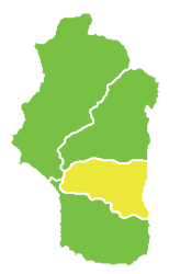 Map of Qardaha District within Latakia Governorate | |
| Coordinates (Qardaha): 35°27′N 36°00′E / 35.45°N 36°ECoordinates: 35°27′N 36°00′E / 35.45°N 36°E | |
| Country |
 Syria Syria |
| Governorate | Latakia |
| Seat | Qardaha |
| Subdistricts | 4 nawāḥī |
| Area | |
| • Total | 360.91 km2 (139.35 sq mi) |
| Population (2004)[1] | |
| • Total | 75,279 |
| • Density | 210/km2 (540/sq mi) |
| Geocode | SY0604 |
Qardaha District (Arabic: منطقة القرداحة, translit. manṭiqat al-Qardāḥah) is a district of the Latakia Governorate in northwestern Syria. Administrative centre is the city of Qardaha. At the 2004 census, the district had a population of 75,279.[1]
Sub-districts
The district of Qardaha is divided into four sub-districts or nawāḥī (population as of 2004[1]):
- Qardaha Nahiyah (ناحية القرداحة): population 44,510.[2]
- Harf al-Musaytirah Nahiyah (ناحية حرف المسيترة): population 6,669.[3]
- Al-Fakhurah Nahiyah (ناحية الفاخورة): population 18,357.[4]
- Jawbat Burghal Nahiyah (ناحية جوبة برغال): population 5,743.[5]
References
- 1 2 3 "2004 Census Data". UN OCHA. Retrieved 15 October 2015.
- ↑ "Qardaha nahiyah population". Cbssyr.org. Retrieved 2012-06-20.
- ↑ "Harf al-Musaytirah nahiyah population". Cbssyr.org. Retrieved 2012-06-20.
- ↑ "Al-Fakhurah nahiyah population". Cbssyr.org. Retrieved 2012-06-20.
- ↑ "Jawbat Burghal nahiyah population". Cbssyr.org. Retrieved 2012-06-20.
This article is issued from Wikipedia - version of the 7/21/2016. The text is available under the Creative Commons Attribution/Share Alike but additional terms may apply for the media files.