Qinggil County
Not to be confused with Qinghe County, Hebei.
| Qinggil County 青河县 • شىڭگىل اۋدانى • چىڭگىل ناھىيىسى (Chinese) • (Uyghur) • (Kazakh) | |
|---|---|
| County | |
| Uyghur transcription(s) | |
| • Uyghur script | چىڭگىل ناھىيىسى |
| • Latin Yëziqi | Chinggil nahiyisi |
| • Yengi Yezik̡ | Qinggil naⱨiyisi |
| • Siril Yëziqi | Чиңгил наһийиси |
| Chinese transcription(s) | |
| • Simplified | 青河县 |
| • Traditional | 青河縣 |
| • Pinyin | Qīnghé Xiàn |
.png) Location of Qinggil County (pink) in Altay Prefecture (yellow) and Xinjiang | |
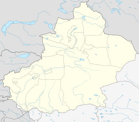  Qinggil Location of the county town in Xinjiang | |
| Coordinates: 46°37′N 90°25′E / 46.617°N 90.417°ECoordinates: 46°37′N 90°25′E / 46.617°N 90.417°E | |
| Country | People's Republic of China |
| Region | Xinjiang |
| Prefecture | Altay |
| County seat | Qinggil (青河镇) |
| Area | |
| • Total | 15,722 km2 (6,070 sq mi) |
| Elevation | 1,220 m (4,000 ft) |
| Population | |
| • Total | 60,000 |
| • Density | 3.8/km2 (9.9/sq mi) |
| Time zone | China Standard (UTC+8) |
| Postal code | 836200 |
| Website |
xjqh |
Qinghe (Qinggil) County (Uyghur: چىڭگىل ناھىيىسى, Чиңгил Наһийиси; Chinese: 青河县; Kazakh: شىڭگىل اۋدانى, Шыңгыл Ауданы) is a county situated in northeastern Xinjiang, China, bordering Mongolia to the east and under the administration of the Altay Prefecture. It has an area of 15,722 km2 (6,070 sq mi) with a population of 60,000. Qinghe was the site of a meteorite impact in 1898 and a Mongolian–Chinese border clash in the spring of 1944.
See also
External links
This article is issued from Wikipedia - version of the 5/23/2016. The text is available under the Creative Commons Attribution/Share Alike but additional terms may apply for the media files.