Quechee Gorge
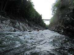
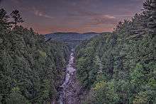
The Quechee Gorge is located in Quechee, Vermont along U.S. Route 4. The gorge is 165 feet deep and is the deepest gorge in Vermont. It serves as a popular tourist attraction in Quechee State Park and can be viewed from the U.S. Route 4 bridge and from trails on both sides of the gorge.[1] The Ottauquechee River flows through the bottom of the gorge and is a popular whitewater kayak run.[2]
Geology
The gorge was carved approximately 13,000 years ago as the Laurentide ice sheet retreated across the region. The carving is thought to be a result of rapid downcutting of the Ottauquechee River after the drainage of glacial Lake Hitchcock.[3] The gorge cuts through bedrock of the Devonian Gile Mountain Formation and Mesozoic mafic dikes can be seen on the west wall.[4][5]
References
- ↑ "Quechee State Park". State of Vermont. 2009. Archived from the original on February 15, 2014. Retrieved February 11, 2014.
- ↑ "American White Water - Just above Route 4 to 1 Mile below Route 4 (Quechee Gorge)". State of Vermont. 1999–2014. Retrieved February 11, 2014.
- ↑ "Quechee Gorge Geology" (PDF). State of Vermont. 2009. Retrieved February 11, 2014.
- ↑ "Geology of Vermont, Quechee Gorge, Hartford, VT". State of Vermont. 2009. Retrieved February 11, 2014.
- ↑ McHone, Gregory, 1981, The origin of the Quechee Gorge: Green Mountain Geologist, Vt Geological Society, Fall 1981, Vol. 8, #3.
External links
Coordinates: 43°38′13″N 72°24′20″W / 43.63682°N 72.40561°W