Rampside Lighthouse
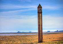 Rampside Lighthouse in 2012. Piel Island can be seen in the distance | |
  Cumbria | |
| Location |
Rampside Cumbria England |
|---|---|
| Coordinates | 54°05′11″N 3°09′40″W / 54.08644°N 3.16121°WCoordinates: 54°05′11″N 3°09′40″W / 54.08644°N 3.16121°W |
| Year first constructed | 1875 |
| Construction | brick |
| Tower shape | square obelisk with window near top for light |
| Markings / pattern | red and yellow brick in vertical stripes |
| Height | 16 metres (52 ft) |
| Focal height | 14 metres (46 ft) |
| Light source | mains power |
| Characteristic | Iso W 2s. |
| Admiralty number | A4824.1 |
| NGA number | 5076 |
| ARLHS number | ENG-201 |
| Managing agent | Port of Barrow[1] |
Rampside Lighthouse, also known as "The Needle", is a leading light (navigation beacon) located in the Rampside area of Barrow-in-Furness, Cumbria, England.[2] Built in 1875, it is the only surviving example of 13 such beacons built around Barrow during the late 19th century to aid vessels into the town's port.[3] It stands 20 metres (66 ft) tall and is constructed from red and yellow bricks. Rampside Lighthouse was designated a Grade II listed building by English Heritage in 1991.[2]
See also
References
- ↑ Rampside The Lighthouse Directory. University of North Carolina at Chapel Hill. Retrieved May 4, 2016
- 1 2 "Rampside Lighthouse". English Heritage. Retrieved 23 March 2013.
- ↑ "Rampside Lighthouse". Geograph Britain and Ireland. Retrieved 23 March 2013.
External links
 |
Wikimedia Commons has media related to Rampside Lighthouse. |
This article is issued from Wikipedia - version of the 7/1/2016. The text is available under the Creative Commons Attribution/Share Alike but additional terms may apply for the media files.