Red Bridge, Kansas City
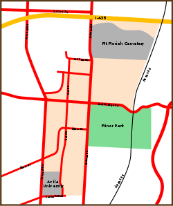
Map of the Red Bridge neighborhood, which is indicated by the tan shaded area on the map
Red Bridge is a neighborhood in South Kansas City. It is centered on the intersection of Red Bridge Road and Holmes Road, on the south side of I-435. Avila University, Minor Park, and the Mount Moriah Cemetery are all located within the Red Bridge neighborhood.
History
A post office called Red Bridge was established in 1888, the name was changed to Redbridge in 1895, and the post office closed in 1902.[1] The community was named for a red bridge near the original town site.[2]
GNIS location
The Geographic Names Information System (GNIS) listing places the location of Red Bridge at 38°55′37″N 94°34′33″W / 38.92695°N 94.57579°W.[3]
Tenants
- Avila University
- Burger King
- DeVry University
- McDonald's
- Mid-Continent Public Library, Red Bridge Branch
- Red Bridge Animal Clinic
- Red Bridge Cinema
- Sonic Drive-In
- Sun Fresh Market
- U.S. Bank
- YMCA of Greater Kansas City
- Farmers Insurance
- CVS
References
- ↑ "Post Offices". Jim Forte Postal History. Retrieved 16 October 2016.
- ↑ "Jackson County Place Names, 1928–1945 (archived)". The State Historical Society of Missouri. Retrieved 16 October 2016.
- ↑ "Red Bridge". Geographic Names Information System. United States Geological Survey. Retrieved 2014-01-25.
External links
Coordinates: 38°55′33″N 94°35′00″W / 38.92577°N 94.58334°W
This article is issued from Wikipedia - version of the 10/17/2016. The text is available under the Creative Commons Attribution/Share Alike but additional terms may apply for the media files.