Reineskarvet
| Reineskarvet | |
|---|---|
| Highest point | |
| Elevation | 1,791 m (5,876 ft) |
| Prominence | 435 m (1,427 ft) [1] |
| Coordinates | 60°46′42″N 8°9′57″E / 60.77833°N 8.16583°ECoordinates: 60°46′42″N 8°9′57″E / 60.77833°N 8.16583°E |
| Geography | |
| Location | Ål, Buskerud, Norway |
| Topo map | 1516 I Gyrinosvatnet |
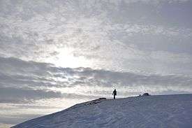
Reineskarvet
Reineskarvet is a significant mountain in the municipality of Ål in Buskerud, Norway.[2]
It is located in the Skarvheimen highland area between Jotunheimen and Hardangervidda, on the north side of Hallingdalen, west of Hemsedal. Reineskarvet looks like Hallingskarvet and lies parallel to it a bit farther north east. The highest point lies in the western end, while there is a summit in the eastern end with elevation 1732 m, popular for hiking.[3]
Gallery

References
- ↑ Toppomania, list of 25 highest in Buskerud
- ↑ Geir Thorsnæs. "Reineskarvet". Store norske leksikon. Retrieved October 1, 2016.
- ↑ Geir Thorsnæs. "Skarvheimen". Store norske leksikon. Retrieved October 1, 2016.
This article is issued from Wikipedia - version of the 10/5/2016. The text is available under the Creative Commons Attribution/Share Alike but additional terms may apply for the media files.