Roads in Azerbaijan
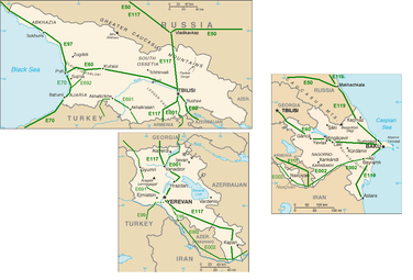
Roads in Azerbaijan are the main transport network in Azerbaijan. With the railway network still undergoing modernization and not covering the entire country, especially mountainous areas and other areas with difficult topography, the road system is the most important form of transport in the country. Its role is important both with national, and as an important transit country, with international traffic.
The total length of the Azerbaijani road network is about 29,000 km, serving domestic cargo traffic and giving access to international main highways. The first modern paved roads, appeared in Azerbaijan in the 19th century when it was part of the Russian Empire. Highways are mostly in fair condition and need an upgrade to international standards in a view to accommodate growing transit traffic. Main and rural roads are in poor condition and in urgent need of rehabilitation and maintenance. The road network, from rural roads to motorways, is today undergoing a rapid modernization with rehabilitations and extensions. For every 1000 km² of national territory, there are 334 km of roads.
Highways in Azerbaijan
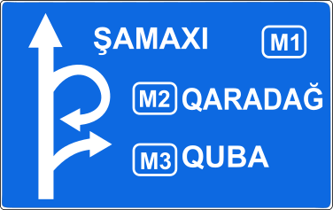
The highway network is 4 lanes (2 in each direction) wide and are illuminated in cities but less frequently in towns. The highway sign in Azerbaijan is blue and locations are shown in capital letters. The main highways in the country are:
| Sign | Number | Route | Length |
|---|---|---|---|
 | R1 | Qəndob – Xaçmaz – Xudat – Yalama – Russia | 88 km |
 | R2 | Giləzi – Xızı | 31 km |
 | R3 | Quba – Qusar | 12 km |
 | R4 | Quba – Xaçmaz | 22 km |
 | R5 | Qusar – Xudat | 29 km |
 | R6 | Hacı Zeynalabdin – Sahil | 40 km |
 | R7 | Hacı Zeynalabdin – Sumqayıt | 18 km |
 | R8 | Muğanlı – İsmayıllı | 40 km |
 | R9 | Qaraməryəm – İsmayıllı – Şəki – Oğuz | 158 km |
 | R10 | Qaraməryəm – Müsüslü | 22 km |
 | R11 | Ağsu – Kürdəmir – İmişli – Bəhramtəpə | 113 km |
 | R12 | Göyçay – Bərgüşad | 18 km |
 | R13 | Göyçay – Ucar | 20 km |
 | R14 | Ağdaş – Ləki | 10 km |
 | R15 | Ağdaş – Zarağan | 45 km |
 | R16 | Qorağan – Qax – Zaqatala | 43 km |
 | R17 | Xaldan – Mingəçevir | 13 km |
 | R18 | Mingəçevir – Mingəçevir Hydro Power Plant – Bəhramtəpə | 166 km |
 | R19 | Ganja – Kəlbəcər – Laçın | 200 km |
 | R20 | Ganja – Daşkəsən | 38 km |
 | R21 | Ganja – Samux | 8 km |
 | R22 | Şəmkir – Gədəbəy | 45 km |
 | R23 | Qazax – Uzuntala – Armenia (closed) | 14 km |
 | R24 | Ağstafa – Poylu – Georgia | 54 km |
 | R25 | Goranboy – Naftalan | 18 km |
 | R26 | Goranboy – Tərtər | 35 km |
 | R27 | Tərtər – Hindarx | 41 km |
 | R28 | Yevlax – Xocalı – Laçın – Xankəndi – Şuşa | 154 km |
 | R29 | Bərdə – İstisu – Kəlbəcər | 164 km |
 | R30 | Xankəndi – Xocavənd | 42 km |
 | R31 | Şuşa – Füzuli | 53 km |
 | R32 | Ucar – Zərdab – Ağcabədi | 76 km |
 | R33 | Ağdam – Hindarx – Ağcabədi | 48 km |
 | R34 | Ağdam – Ağdərə | 26 km |
 | R35 | Ağdam – Füzuli – Horadiz – Xocavənd | 94 km |
 | R36 | Laçın – Həkəri | 83 km |
 | R37 | Laçın – Zabux – Armenia (closed) | 23 km |
 | R38 | Qubadlı – Xanlıq | 16 km |
 | R39 | Həkəri – Zəngilan | 23 km |
 | R40 | Füzuli – Cəbrayil – Mahmudlu | 46 km |
 | R41 | Yuxarı Qarabağ Kanalı – Beyləqan – Daşburun | 32 km |
 | R42 | Bəhramtəpə – Biləsuvar | 62 km |
 | R43 | Biləsuvar – Iran | 19 km |
 | R44 | Hacıqabul – Şirvan | 11 km |
 | R45 | Şirvan – Noxudlu – Salyan | 43 km |
 | R46 | Salyan – Neftçala | 40 km |
 | R47 | Masallı – Yardımlı | 53 km |
 | R48 | Lənkəran – Lerik | 55 km |
 | R49 | Nakhchivan – Şahbuz – Armenia (closed) | 65 km |
 | R50 | M2 (371 km) – Ganja International Airport | 11 km |
 | R51 | M2 (336 km) – Ganja | 8 km |
 | R52 | M2 (317 km) – Train station Kürəkçay | 5 km |
 | R53 | M2 (376 km) – Train station Alabaşlı | 8 km |
 | R54 | M2 (70 km) – Train station Ələt | 5 km |
 | R55 | M3 (220 km) – Train station Masallı | 5 km |
 | R56 | M5 (17 km) – Kərimli | 31 km |
 | R57 | M5 (46 km) – Şəki | 12 km |
 | R58 | M5 (128 km) – Train station Zaqatala | 9 km |
 | R59 | M5 (150 km) – Train station Balakən | 2 km |
 | R60 | M6 (94 km) – İmişli | 7 km |
 | R61 | M6 (250 km) – Zəngilan | 11 km |
 | R62 | M7 (58 km) – Şərur | 4 km |
 | R63 | M7 (80 km) – Sədərək | 8 km |
 | R64 | M8 (3 km) – Babək | 3 km |
 | R65 | M8 (44 km) – Culfa | 2 km |
 | R66 | M8 (75 km) – Train station Ordubad | 5 km |
Motorways
Azerbaijan has recently developed a network of multilane motorways, which is being expanded steadily. The motorway network is 6 lanes (3 in each direction) wide in the countryside, and 8 lanes (4 in each direction) wide and illuminated in and around Baku. The motorway sign in Azerbaijan is blue and locations are shown in capital letters. Motorways are differentiated in number from two-lane main highways.
| Sign | Number | Route | Length | International numbers |
|---|---|---|---|---|
 | M1 | Baku - Abşeron - Sumqayıt - Xızı - Siyəzən - Şabran - Quba - Qusar - Xaçmaz - Russia | 205 km |  |
 | M2 | Baku - Tovuz - Georgia | 507 km |  |
 | M3 | Ələt - Salyan - Lənkəran - Astara - Iran (Astara) | 311 km | |
 | M4 | Baku - Şamaxı - Ağsu - Göyçay - Ağdaş | 253 km | |
 | M5 | Yevlax - Şəki - Zaqatala - Balakən | 184 km | |
 | M6 | Hajiqabul - Şirvan - Bəhramtəpə - Horadiz - Zəngilan - Armenia (closed) | 290 km |  |
 | M7 | Nakhchivan - Babək - Kəngərli - Şərur - Sədərək - Turkey | 81 km | |
 | M8 | Culfa - Ordubad - Armenia (closed) | 89 km | |
References
 This article incorporates public domain material from the CIA World Factbook website https://www.cia.gov/library/publications/the-world-factbook/index.html.