Route 1 (Uruguay)
| ||||
|---|---|---|---|---|
| Ruta 1 | ||||
| Brigadier General Manuel Oribe | ||||
 | ||||
| Route information | ||||
| Maintenance: Ministry of Transport & Public Works | ||||
| Length: | 174.29 km (108.30 mi) | |||
| Major junctions | ||||
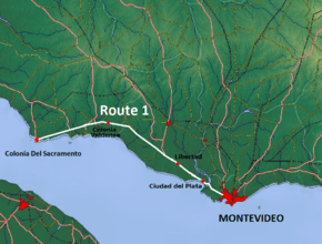
| East end: | Montevideo (Bella Vista) | |||
|
Montevideo Department: | ||||
| West end: | Colonia del Sacramento | |||
| Highway system | ||||
| ||||


Route 1 is a national route of Uruguay. In 1975, it was assigned the name Brigadier General Manuel Oribe, a national hero of Uruguay.[1] It connects Montevideo with Colonia del Sacramento to the west along the coast. The road is approximately 177 kilometres (110 mi) in length.[2][3]
The distance notation along Route 1 uses the same Kilometre Zero reference as Routes 3, 5, 6, 7, 8, 9 and IB, which is the Pillar of Peace of Plaza de Cagancha in the Centro of Montevideo.[4]
Route 1 crosses the Santa Lucia River on the border between the departments of Montevideo and San Jose along a modern 4-lane bridge with a length of 800 metres. It was crossed by the old 2-lane bridge opened in 1925 on the old Route 1, which still exists today and is used as a shortcut by the people of Santiago Vázquez.
Destinations and junctions
These are the populated places Route 5 passes through, as well as its main junctions with other National Roads.
- Montevideo Department
- Km. 9 La Paloma - Tomkinson, Route 5 North to Canelones, Florida, Durazno, Tacuarembó and Rivera.
- San José Department
- Km. 52 Libertad, Route 45 North to Rodríguez
- Km. 61 (6.5 km after Puntas de Valdez), Route 3 North to San José, Trinidad, Young, Paysandú, Salto and Bella Unión.
- Km. 101 Ecilda Paullier, Route 11 East to San José de Mayo, Canelones, Atlántida and Route IB
- Colonia Department
- Km. 127 (7 km after Colonia Valdense), Route 2 North to Rosario, Cardona, and the Northwest to Mercedes, Fray Bentos and Route 136 of Argentina.
- Km. 137 (17 km after Colonia Valdense), Route 54 South to Juan Lacaze, Route 54 North to Route 12.
- Km. 148 (28 km after Colonia Valdense), Route 22 North to Tarariras and then Northwest to Route 21.
- Km. 163 (43 km after Colonia Valdense), Route 50 Northeast to Tarariras
- Km. 177 Ends into Avenida Franklin D. Roosevelt of Colonia del Sacramento.
References
- ↑ "LEY N° 14.361". República Oriental del Uruguay, Poder Legislativo. 1975. Retrieved 19 July 2011.
- ↑ "Mapas & Planos - República Oriental del Uruguay". Reservas.net. Retrieved 31 May 2011.
- ↑ "Information about the routes of Uruguay" (in Spanish). Turismo en Uruguay – Turismo Uruguayo .com. 2011. Retrieved 16 July 2011.
- ↑ "Kilómetro cero en Plaza Cagancha". Junta Departamental de Montevideo. 25 March 2010. Retrieved 21 July 2011.
External links
 |
Wikimedia Commons has media related to Route 1 (Uruguay). |
Coordinates: 34°21′56″S 57°3′39.6″W / 34.36556°S 57.061000°W