South Dakota Highway 20
| ||||
|---|---|---|---|---|
|
Route of SD 20 (in red) | ||||
| Route information | ||||
| Defined by SDCL §31-4-145 | ||||
| Maintained by SDDOT | ||||
| Length: | 428.852 mi[1][2][3] (690.170 km) | |||
| Existed: | 1929 – present | |||
| Western section | ||||
| Length: | 389.828 mi[1][2][3] (627.367 km) | |||
| West end: | Montana state line near Camp Crook | |||
| Major junctions: |
 US 85 in Buffalo US 85 in Buffalo US 12 in Mobridge US 12 in Mobridge US 83 in Selby US 83 in Selby US 281 west of Mellette US 281 west of Mellette | |||
| East end: |
 US 212 in Watertown US 212 in Watertown | |||
| Eastern section | ||||
| Length: | 39.024 mi[3] (62.803 km) | |||
| West end: |
  I-29 / US 81 west of South Shore I-29 / US 81 west of South Shore | |||
| East end: |
 MN 40 at the Minnesota state line east of Revillo MN 40 at the Minnesota state line east of Revillo | |||
| Location | ||||
| Counties: | Harding, Perkins, Ziebach, Dewey, Corson, Walworth, Potter, Faulk, Spink, Clark, Codington, Grant | |||
| Highway system | ||||
| ||||

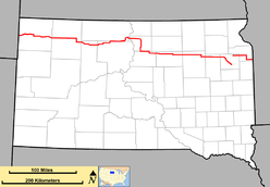


South Dakota Highway 20 (SD 20) is a state route that largely runs from border to border across the northern part of the U.S. state of South Dakota. It is one of the state's most rural highways.[4]
South Dakota Highway 20 consists of two segments. The longer segment begins at the Montana border west of Camp Crook, and terminates at the junction of U.S. Route 212 (US 212) in Watertown. This segment is just less than 390 miles (630 km) in length. A second segment begins just west of an interchange with Interstate 29 (I-29) and US 81. It continues eastward to the Minnesota border east of Revillo, then becomes Minnesota State Highway 40 (MN 40). This second segment is just over 39 miles (63 km) in length, and the total length of the route is about 429 miles (690 km).
History
South Dakota 20 was implemented in 1929, but it was much shorter. The western terminus was at South Dakota Highway 45 northeast of Faulkton, and terminated in Watertown. Around 1944, the western terminus was moved further west, to U.S. Highway 83.
In the early 1950s, a short extension west was made again, to the town of Akaska. The eastern terminus was moved as well, to U.S. Highway 77 south of Milbank; the extension to the Minnesota border occurred in 1954.
In the late 1960s, the short stub between Akaska and U.S. 83 was redesignated as South Dakota Highway 20 Spur. SD 20 was extended northward along U.S. 83 to U.S. Highway 12, then through Mobridge and across north central and northwest South Dakota, absorbing the alignment of what had been South Dakota Highway 8.
Major intersections
| County | Location | mi[1][2][3] | km | Destinations | Notes | ||
|---|---|---|---|---|---|---|---|
| Carter | | 0.000 | 0.000 | Tie Creek Road | Continuation into Montana | ||
| Harding | Buffalo | 26.130 | 42.052 | US 85 north – Bowman | Northern end of US 85 concurrency | ||
| | 27.655 | 44.506 | US 85 south – Belle Fourche | Southern end of US 85 concurrency | |||
| | 50.030 | 80.515 |  SD 79 south – Newell SD 79 south – Newell | Western end of SD 79 concurrency | |||
| | 54.483 | 87.682 | SD 79 north – Reeder | Eastern end of SD 79 concurrency | |||
| Perkins | | 72.193 | 116.183 |  SD 75 north – Hettinger SD 75 north – Hettinger | |||
| | 95.210 | 153.226 |  SD 73 north – Lemmon SD 73 north – Lemmon | Northern end of SD 73 concurrency | |||
| | 101.187 | 162.845 | SD 73 south – Faith | Southern end of SD 73 concurrency | |||
| Ziebach | | 127.223 | 204.746 |  SD 65 south – Dupree SD 65 south – Dupree | Western end of SD 65 concurrency | ||
| Dewey | Isabel | 130.881 | 210.633 | SD 65 north – McIntosh | Eastern end of SD 65 concurrency | ||
| | 142.647 | 229.568 |  SD 63 south – Eagle Butte SD 63 south – Eagle Butte | Western end of SD 63 concurrency | |||
| | 164.952 | 265.465 | SD 63 north – McLaughlin | Eastern end of SD 63 concurrency | |||
| Corson | | 182.033 | 292.954 | US 12 west – McLaughlin | Western end of US 12 concurrency | ||
| | 185.095 | 297.882 |  SD 1806 south SD 1806 south | Western end of SD 1806 concurrency | |||
| | 186.267 | 299.768 | SD 1806 north – Fort Yates, ND | Eastern end of SD 1806 concurrency | |||
| Walworth | Mobridge | 190.508 | 306.593 |  SD 1804 north – Pollock SD 1804 north – Pollock | Western end of SD 1804 concurrency | ||
| | 194.386 | 312.834 | SD 1804 south – Akaska | Eastern end of SD 1804 concurrency | |||
| | 208.759 | 335.965 | US 83 north – Mound City | Northern end of US 83 concurrency | |||
| Selby | 211.623 | 340.574 |  SD 130 east – Java SD 130 east – Java | ||||
| | 215.876 | 347.419 | US 12 east – Bowdle, Aberdeen | Eastern end of US 12 concurrency | |||
| | 224.663 | 361.560 |  SD 144 west – Akaska SD 144 west – Akaska | ||||
| | 230.710 | 371.292 | US 83 south – Agar, Pierre | Southern end of US 83 concurrency | |||
| | 243.723 | 392.234 |  SD 47 north SD 47 north | Northern end of SD 47 concurrency | |||
| Potter | | 247.403 | 398.157 | SD 47 south – Lebanon | Southern end of SD 47 concurrency | ||
| Faulk | | 284.415 | 457.722 |  SD 45 north – Ipswich SD 45 north – Ipswich | Northern end of SD 45 concurrency | ||
| | 286.422 | 460.952 | SD 45 south – Miller | Southern end of SD 45 concurrency | |||
| Spink | | 314.227 | 505.699 | US 281 – Aberdeen, Redfield | |||
| Conde | 334.227 | 537.886 |  SD 37 north – Verdon, Groton SD 37 north – Verdon, Groton | Northern end of SD 37 concurrency | |||
| | 334.236 | 537.901 | SD 37 south – Turton, Doland | Southern end of SD 37 concurrency | |||
| Clark | | 362.337 | 583.125 |  SD 25 – Webster, DeSmet SD 25 – Webster, DeSmet | |||
| Codington | Watertown | 389.828 | 627.367 | US 212 – Henry, Kranzburg | |||
| Gap in route | |||||||
| Codington | | 389.828 | 627.367 | 157th Street | Begin state maintenance | ||
| | 392.017– 392.217 | 630.890– 631.212 | I-29 / US 81 – Fargo, Brookings | I-29 exit 193. | |||
| Grant | | 412.690 | 664.160 |   SD 15 north / SD 158 east – Milbank SD 15 north / SD 158 east – Milbank | Northern end of SD 15 concurrency | ||
| | 419.712 | 675.461 | SD 15 south – Clear Lake | Southern end of SD 15 concurrency | |||
| Lac qui Parle | | 428.852 | 690.170 | MN 40 east – Marietta | Continuation into Minnesota | ||
1.000 mi = 1.609 km; 1.000 km = 0.621 mi
| |||||||
See also
-
 South Dakota portal
 -
 U.S. Roads portal
 - List of South Dakota numbered highways
References
- 1 2 3 "State Highway Log: Rapid City Region" (PDF). South Dakota Department of Transportation. January 2012. Retrieved December 26, 2013.
- 1 2 3 "State Highway Log: Pierre Region" (PDF). South Dakota Department of Transportation. January 2012. Retrieved December 26, 2013.
- 1 2 3 4 "State Highway Log: Aberdeen Region" (PDF). South Dakota Department of Transportation. January 2012. Retrieved December 26, 2013.
- ↑ Andrews, John (November 2010). "The Road Less Traveled". South Dakota Magazine.