Saint-Charles Parish, New Brunswick
| Saint-Charles St. Charles | |
|---|---|
| Parish | |
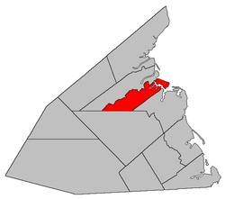 Location within Kent County, New Brunswick. | |
| Coordinates: 46°40′N 64°59′W / 46.67°N 64.98°W | |
| Country |
 Canada Canada |
| Province |
 New Brunswick New Brunswick |
| County | Kent County |
| Established | 1908 |
| Area[1] | |
| • Land | 174.78 km2 (67.48 sq mi) |
| Population (2011)[1] | |
| • Total | 1,982 |
| • Density | 11.3/km2 (29/sq mi) |
| • Pop 2006-2011 |
 5.3% 5.3% |
| • Dwellings | 1,052 |
| Time zone | AST (UTC-4) |
| • Summer (DST) | ADT (UTC-3) |
Saint-Charles is a Canadian parish in Kent County, New Brunswick.[2]
Its population in the 2011 Census was 1,982.
Delineation
Saint-Charles Parish is defined in the Territorial Division Act[3] as being bounded:
- Beginning on the shore of the Gulf of Saint Lawrence at the southeastern angle or corner of a lot of land formerly owned by James Babin; thence following the southern line of said lot in a westerly direction to the southern line of lot 55, granted to John David, thence following the said southern line to the southwestern angle or corner of said lot 55; thence in a straight southwesterly direction till it meets the boundary line between the Weldford Parish and the Richibucto Parish, as established by the Consolidated Statutes, 1903, Chapter 2; thence in a westerly direction, following the said boundary line to a point where the Canadian National Railways line crosses the Weldford Parish line, thence in a northerly direction to the rear line running between the Saint-Charles River and the St-Louis River;[lower-alpha 1] thence in an easterly direction following the said rear line to the shore of the Gulf of Saint Lawrence, including all islands in front thereof.
Communities
|
|
Demographics
PopulationPopulation trend[5]
|
LanguageMother tongue language (2006)[6]
|

See also
Footnotes
- ↑ Poor wording in the 1952 Revised Statutes was made even worse in 1973. The boundary line runs along the rear of grants on the southern side of the Kouchibouguacis River.[4]
References
- 1 2 2011 Statistics Canada Census Profile: Saint-Charles Parish, New Brunswick
- ↑ New Brunswick Provincial Archives - Saint-Charles Parish
- ↑ "Territorial Division Act (R.S.N.B. 1973, c. T-3)". Government of New Brunswick website. Retrieved 25 August 2016.
- ↑ "Crown Grant Reference Map Viewer". GeoNB. Government of New Brunswick. Retrieved 25 August 2016.
- ↑ Statistics Canada: 1996, 2001, 2006 census
- ↑ 2006 Statistics Canada Community Profile: Saint-Charles Parish, New Brunswick
 |
Saint-Louis Parish | | ||
 |
Northumberland Strait | |||
| ||||
 | ||||
| Weldford Parish | Richibucto Parish |


| Subdivisions of New Brunswick | |
|---|---|
| Subdivisions | |
| Cities | |
| Counties | |
| |


Coordinates: 46°40′12″N 64°58′48″W / 46.67000°N 64.98000°W
This article is issued from Wikipedia - version of the 8/25/2016. The text is available under the Creative Commons Attribution/Share Alike but additional terms may apply for the media files.