San Sebastián de los Reyes
For other uses, see San Sebastian.
| San Sebastián de los Reyes | |||
|---|---|---|---|
| Municipality | |||
| |||
| Nickname(s): Sanse, Pamplona chica | |||
_mapa.svg.png) Location of San Sebastián de los Reyes within Madrid | |||
| Coordinates: 40°32′49″N 3°37′33″W / 40.54694°N 3.62583°W | |||
| Country |
 Spain Spain | ||
| Region |
 Community of Madrid Community of Madrid | ||
| Comarca | Madrid metropolitan area | ||
| Founded | 1492 | ||
| Government | |||
| • Type | Ayuntamiento | ||
| • Mayor | Manuel Ángel Fernández Mateo (PP) | ||
| Area | |||
| • Total | 59.26 km2 (22.88 sq mi) | ||
| • Land | 59.26 km2 (22.88 sq mi) | ||
| Elevation | 730 m (2,400 ft) | ||
| Population (2009)INE | |||
| • Total | 75,912 | ||
| • Density | 1,170/km2 (3,000/sq mi) | ||
| Time zone | CET (GMT +1) | ||
| • Summer (DST) | CEST (GMT +2) (UTC) | ||
| Post code | 28701-28703, 28706-28709 | ||
| Area code(s) | +34 91 | ||
| Website | http://www.ssreyes.org/ | ||
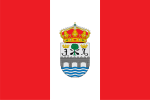
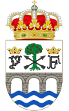
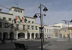
Town hall
San Sebastián de los Reyes (colloquially called "Sanse") is a municipality in the Community of Madrid in Spain. Founded in 1492, it is located 20 km north of Madrid. The city is twinned with Baunatal in Germany. It is geographically joined with neighboring Alcobendas and they share a common RENFE commuter line to Madrid Atocha. Access by road is also excellent as it lies at the northernmost junctions of the motorway network to Zaragoza, Burgos, Barajas airport, and the Madrid motorway highway. Major industrial companies have branches in San Sebastián de los Reyes, including IKEA, Leroy Merlin, PC City, Selther, Carrefour, Alternate, Media Markt, Telepizza, Antena 3, and many more.
Town twinning

External links
 |
Wikimedia Commons has media related to San Sebastián de los Reyes. |
Municipalities of the Madrid Metropolitan Area | ||
|---|---|---|
| 3,000,000+ |  | |
| 200,000+ | ||
| 150,000+ | ||
| 100,000+ | ||
| 50,000+ | ||
| 25,000+ | ||
This article is issued from Wikipedia - version of the 6/4/2014. The text is available under the Creative Commons Attribution/Share Alike but additional terms may apply for the media files.