Sangareddy district
This article is about the district. For its eponymous headquarters, see Sangareddy.
| Sangareddy district సంగారెడ్డి జిల్లా سنگاريڈى ڈسسٹک | |
|---|---|
| District of Telangana | |
| Country | India |
| State | Telangana |
| Tehsils | 20 |
| Government | |
| • District collector | K.Manicka Raj |
| Area | |
| • Total | 4,464.87 km2 (1,723.90 sq mi) |
| Population (2011) | |
| • Total | 1,527,628 |
| • Density | 340/km2 (890/sq mi) |
| Website | Official website |
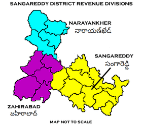
Sangareddy District Revenue divisions
Sangareddy district is a district located in the northern region of the Indian state of Telangana.[1]
Geography
The district is spread over an area of 4,464.87 square kilometres (1,723.90 sq mi).[2]
Demographics
As of 2011 Census of India, the district has a population of 1,527,628.[2]
Administrative divisions
The district will have two revenue divisions of Narayankhed, Sangareddy and Zaheerabad are sub-divided into 20 mandals.[1] K.Manicka Raj is the present collector of the district.[3]
Mandals
| S.No. | Narayankhed revenue division | Sangareddy revenue division | Zaheerabad revenue division |
|---|---|---|---|
| 1 | Kalher | Ameenpur | Jharasangam |
| 2 | Kangti | Andole | Kohir |
| 3 | Manoor | Gummadidala | Mogudampally |
| 4 | Nagilgidda | Hathnoora | Nyalkal |
| 5 | Narayankhed | Jinnaram | Raikode |
| 6 | Sirgapoor | Kandi | Sangareddy |
| 7 | Kondapur | Zahirabad | |
| 8 | Munipally | ||
| 9 | Patancheru | ||
| 10 | Pulkal | ||
| 11 | Ramchandrapuram | ||
| 12 | Sadasivpet | ||
| 13 | Sangareddy | ||
| 14 | Vatpally |
See also
References
- 1 2 "Sangareddy district" (PDF). New Districts Formation Portal. Retrieved 11 October 2016.
- 1 2 "New districts". Andhra Jyothy.com. 8 October 2016. Retrieved 8 October 2016.
- ↑ "K Chandrasekhar Rao appoints collectors for new districts". Deccan Chronicle. 11 October 2016. Retrieved 13 October 2016.
External links
 |
Medak district | Medak district | | |
 |
Malkajgiri district | |||
| ||||
 | ||||
| Ranga Reddy district | Ranga Reddy district |


This article is issued from Wikipedia - version of the 11/1/2016. The text is available under the Creative Commons Attribution/Share Alike but additional terms may apply for the media files.