Shippegan Parish, New Brunswick
| Shippegan Shippagan | |
|---|---|
| Parish | |
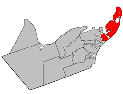 Location within Gloucester County, New Brunswick | |
| Coordinates: 47°51′18″N 64°37′12″W / 47.855°N 64.62°W | |
| Country |
 Canada Canada |
| Province |
 New Brunswick New Brunswick |
| County | Gloucester |
| Established | 1851 |
| Area[1] | |
| • Land | 207.25 km2 (80.02 sq mi) |
| Population (2011)[1] | |
| • Total | 5,004 |
| • Density | 24.1/km2 (62/sq mi) |
| • Pop 2006-2011 |
 6.8% 6.8% |
| • Dwellings | 2,479 |
| Time zone | AST (UTC-4) |
| • Summer (DST) | ADT (UTC-3) |
Shippegan (incorrectly Shippagan from the French colloquial spelling) is a Canadian parish in Gloucester County, New Brunswick.[2]
Delineation
Shippegan Parish is defined in the Territorial Division Act[3] as being bounded:
- West by Caraquet Parish; northwesterly by Caraquet Bay and Chaleur Bay; and southeasterly by the Gulf of Saint-Lawrence, including the islands of Shippegan[lower-alpha 1] and Miscou.
Communities
Parish population total does not include incorporated municipalities (in bold):
|
|
|
Demographics
PopulationPopulation trend[6]
|
LanguageMother tongue language (2006)[7]
|

See also
Footnotes
References
- 1 2 2011 Statistics Canada Census Profile: Shippagan Parish, New Brunswick
- ↑ New Brunswick Provincial Archives - Shippagan Parish
- ↑ "Territorial Division Act (R.S.N.B. 1973, c. T-3)". Government of New Brunswick website. Retrieved 25 August 2016.
- ↑ "Crown Grant Reference Map Viewer". GeoNB. Government of New Brunswick. Retrieved 25 August 2016.
- ↑ "Taylor Island". Canadian Geographical Names. Natural Resources Canada. Retrieved 26 August 2016.
- ↑ Statistics Canada: 1996, 2001, 2006 census
- ↑ 2006 Statistics Canada Community Profile: Shippagan Parish, New Brunswick
 |
Chaleur Bay | | ||
| Caraquet Parish |  |
Gulf of Saint Lawrence | ||
| ||||
 | ||||
| Gulf of Saint Lawrence |


| Subdivisions of New Brunswick | |
|---|---|
| Subdivisions | |
| Cities | |
| Counties | |
| |


Coordinates: 47°51′18″N 64°37′12″W / 47.85500°N 64.62000°W
This article is issued from Wikipedia - version of the 8/26/2016. The text is available under the Creative Commons Attribution/Share Alike but additional terms may apply for the media files.