Spodnji Petelinjek
| Spodnji Petelinjek | |
|---|---|
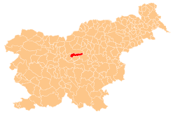
  Spodnji Petelinjek Location in Slovenia | |
| Coordinates: 46°10′45.41″N 14°49′37.96″E / 46.1792806°N 14.8272111°ECoordinates: 46°10′45.41″N 14°49′37.96″E / 46.1792806°N 14.8272111°E | |
| Country |
 Slovenia Slovenia |
| Traditional region | Upper Carniola |
| Statistical region | Central Slovenia |
| Municipality | Lukovica |
| Area | |
| • Total | 0.29 km2 (0.11 sq mi) |
| Elevation | 451 m (1,480 ft) |
| Population (2002) | |
| • Total | 26 |
| [1] | |
Spodnji Petelinjek (pronounced [ˈspoːdnji pɛtɛˈliːnjɛk]; German: Unterpetelinek[2]) is a small settlement east of Blagovica in the Municipality of Lukovica in the eastern part of the Upper Carniola region of Slovenia.[3]
References
- ↑ Statistical Office of the Republic of Slovenia
- ↑ Leksikon občin kraljestev in dežel zastopanih v državnem zboru, vol. 6: Kranjsko. 1906. Vienna: C. Kr. Dvorna in Državna Tiskarna, p. 16.
- ↑ Lukovica municipal site
External links
This article is issued from Wikipedia - version of the 6/29/2015. The text is available under the Creative Commons Attribution/Share Alike but additional terms may apply for the media files.