Starobesheve Raion
| Starobeshivskyi Raion Старобешівський район | |||
|---|---|---|---|
| Raion | |||
| |||
 | |||
| Coordinates: 47°45′12″N 38°1′54″E / 47.75333°N 38.03167°ECoordinates: 47°45′12″N 38°1′54″E / 47.75333°N 38.03167°E | |||
| Country |
 Ukraine Ukraine | ||
| Region | Donetsk Oblast | ||
| Established | 1923 | ||
| Admin. center | Starobesheve | ||
| Subdivisions |
List
| ||
| Government | |||
| • Governor | Vasyl′ Pan′ko | ||
| Area | |||
| • Total | 1,282 km2 (495 sq mi) | ||
| Population (2013) | |||
| • Total |
 50,675 50,675 | ||
| Time zone | EET (UTC+2) | ||
| • Summer (DST) | EEST (UTC+3) | ||
| Postal index | 87200—87272 | ||
| Area code | +380 6253 | ||


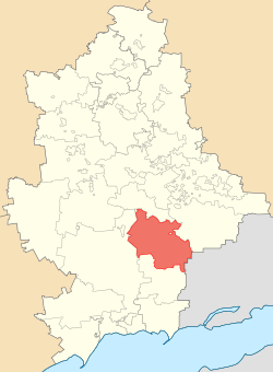
Starobesheve Raion (Ukrainian: Старобешівський район) is one of the 33 raions of Donetsk Oblast, located in southeastern Ukraine. The administrative center of the raion is the urban-type settlement of Starobesheve. Population: 50,675 (2013 est.)[1].
One of the towns in the raion is Novyi Svit.[2] On 29 July 2014, Ukrainian forces reportedly secured this town from pro-Russian separatists.[2][3] Starting mid-April 2014 pro-Russian separatists captured several towns in Donetsk Oblast.[4][5]
Demographics
According to the 2001 Ukrainian Census:[6]
| Ethnicity | ||
| Ukrainians | 29,170 | 52.1% |
| Russians | 17,761 | 31.7% |
| Greeks | 7,491 | 13.4% |
| Belarusians | 397 | 0.7% |
| Azerbaijanis | 241 | 0.4% |
| Germans | 171 | 0.3% |
| Armenians | 122 | 0.2% |
References
- ↑ "Чисельність наявного населення України (Actual population of Ukraine)" (in Ukrainian). State Statistics Service of Ukraine. Retrieved 21 January 2015.
- 1 2 (Ukrainian) Battalion "Azov" occupied the city Novyi Svit in Donetsk, Ukrayinska Pravda (24 July 2014)
- ↑ http://www.nrcu.gov.ua/en/148/572407/
- ↑ http://www.newrepublic.com/article/117387/putin-accidentally-helping-unite-eastern-and-western-ukraine
- ↑ http://en.itar-tass.com/world/735082
- ↑ "Національний склад та рідна мова населення Донецької області" [Ethnic and linguistic composition of Donetsk Oblast] (in Ukrainian). Archived from the original on 27 November 2012.
| Raions |  | ||||||
|---|---|---|---|---|---|---|---|
| Cities |
| ||||||
| |||||||

This article is issued from Wikipedia - version of the 10/16/2016. The text is available under the Creative Commons Attribution/Share Alike but additional terms may apply for the media files.