New Tanegashima Airport
| New Tanegashima Airport 新種子島空港 Shin Tanegashima Kūkō | |||||||||||
|---|---|---|---|---|---|---|---|---|---|---|---|
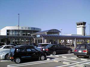 | |||||||||||
| IATA: TNE – ICAO: RJFG | |||||||||||
| Summary | |||||||||||
| Airport type | Public | ||||||||||
| Operator | Government | ||||||||||
| Location | Tanegashima, Kagoshima Prefecture, Japan | ||||||||||
| Elevation AMSL | 768 ft / 234 m | ||||||||||
| Coordinates | 30°36′18″N 130°59′30″E / 30.60500°N 130.99167°ECoordinates: 30°36′18″N 130°59′30″E / 30.60500°N 130.99167°E | ||||||||||
| Map | |||||||||||
  RJFG Location in Japan | |||||||||||
| Runways | |||||||||||
| |||||||||||
| Statistics (2014) | |||||||||||
| |||||||||||
New Tanegashima Airport (新種子島空港 Shin Tanegashima Kūkō) (IATA: TNE, ICAO: RJFG), also known as Tanegashima Airport,[3] is located in Nakatane, on Tanegashima, one of the Ōsumi Islands in southern Kagoshima Prefecture, Japan.
The original Tanegashima Airport was opened on July 27, 1962 at a site approximately 8 kilometres (5.0 mi) southeast of the present airport. Although its runway was extended from 1,000 m (3,300 ft) to 1,500 m (4,900 ft) in 1973, it was not suitable to handle jet aircraft, and was closed on March 16, 2006, the day that the New Tanegashima Airport, with a 2,000 m (6,600 ft) runway was opened.
Airlines and destinations
Passenger
| Airlines | Destinations |
|---|---|
| Japan Airlines operated by Japan Air Commuter | Kagoshima |
References
- ↑ AIS Japan
- ↑ "New Tanegashima Airport Statistics" (PDF) (Press release). Osaka Ministry of Land, Infrastructure and Transport Civil Aviation Bureau. Retrieved 8 July 2016.
- ↑ Tanegashima Airport guide from Japan Airlines
External links
 |
Wikimedia Commons has media related to Tanegashima Airport. |
1 Joint civil-military use | |||||||||||
| Major hubs | |||||||||||
| International |
| ||||||||||
| Domestic |
| ||||||||||
| General aviation |
| ||||||||||
| Military | |||||||||||
| Heliports |
| ||||||||||
| Defunct | |||||||||||


This article is issued from Wikipedia - version of the 12/4/2016. The text is available under the Creative Commons Attribution/Share Alike but additional terms may apply for the media files.