Texas State Highway 135
| ||||
|---|---|---|---|---|
 | ||||
| Route information | ||||
| Maintained by TxDOT | ||||
| Length: | 46.7 mi[1] (75.2 km) | |||
| Existed: | before 1933 – present | |||
| Major junctions | ||||
| South end: |
 US 69 at Jacksonville US 69 at Jacksonville | |||
 I-20 in Liberty City I-20 in Liberty City | ||||
| North end: |
 US 271 near Gladewater US 271 near Gladewater | |||
| Location | ||||
| Counties: | Cherokee, Smith, Rusk, Gregg | |||
| Highway system | ||||
| ||||


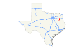
State Highway 135 or SH 135 is a Texas state highway that runs from Jacksonville to near Gladewater in east Texas (USA). The route was designated by 1933 from Gladewater to Troup, and was extended over a portion of FM 347 to Jacksonville in 1990 (although it was signed by the early 1970s), completing its current route.
Major intersections
| County | Location | mi | km | Destinations | Notes |
|---|---|---|---|---|---|
| Cherokee | Jacksonville | US 69 (Jackson St) – Bullard, Rusk | |||
| |  FM 2064 east FM 2064 east | ||||
| |   FM 177 west to FM 3052 FM 177 west to FM 3052 | ||||
| | FM 2064 south | ||||
| Smith | Troup |  SH 110 west (Duval St) – Whitehouse SH 110 west (Duval St) – Whitehouse | South end of SH 110 overlap | ||
| SH 110 south (Georgia St) – New Summerfield | North end of SH 110 overlap | ||||
 FM 13 east (Duval St) FM 13 east (Duval St) | |||||
 FM 15 east (Bryant St) FM 15 east (Bryant St) | |||||
| |  FM 345 west FM 345 west | ||||
| Arp |  Spur 80 south (Main St) Spur 80 south (Main St) | ||||
 SH 64 – Tyler, Henderson SH 64 – Tyler, Henderson | Interchange | ||||
| |  FM 838 east FM 838 east | ||||
| Rusk | Overton |  FM 2089 south FM 2089 south | |||
 SH 323 east (Van Buren St) – Henderson SH 323 east (Van Buren St) – Henderson | |||||
 FM 850 (Henderson St) FM 850 (Henderson St) | |||||
| New London |   SH 42 south (Main St) / FM 918 east – Price SH 42 south (Main St) / FM 918 east – Price | South end of SH 42 overlap | |||
| Laird Hill |  FM 2012 FM 2012 | ||||
| Kilgore | SH 42 north (Woodlawn St) | North end of SH 42 overlap | |||
| Gregg |  SH 31 – Tyler, Longview SH 31 – Tyler, Longview | Interchange | |||
| Liberty City | I-20 – Terrell, Longview | I-20 exit 583; interchange. | |||
 FM 1252 (Kilgore Rd) FM 1252 (Kilgore Rd) | |||||
| |  FM 2207 east FM 2207 east | ||||
| | US 271 – Tyler, Gladewater | ||||
| 1.000 mi = 1.609 km; 1.000 km = 0.621 mi | |||||
References
- ↑ Transportation Planning and Programming Division (n.d.). "State Highway No. 135". Highway Designation Files. Texas Department of Transportation. Retrieved 2010-11-01.
This article is issued from Wikipedia - version of the 7/31/2016. The text is available under the Creative Commons Attribution/Share Alike but additional terms may apply for the media files.