Texas State Highway 144
| |||||||
|---|---|---|---|---|---|---|---|
 | |||||||
| Route information | |||||||
| Maintained by TxDOT | |||||||
| Length: | 39.027 mi[1][nb 1] (62.808 km) | ||||||
| Existed: | by 1931 – present | ||||||
| Major junctions | |||||||
| South end: |
 SH 22 in Meridian SH 22 in Meridian | ||||||
 US 67 in Glen Rose US 67 in Glen Rose US 377 in Granbury US 377 in Granbury | |||||||
| North end: |
  Bus. US 377 in Granbury Bus. US 377 in Granbury | ||||||
| Location | |||||||
| Counties: | Bosque, Somervell, Hood | ||||||
| Highway system | |||||||
| |||||||


Texas State Highway 144 (SH 144) is a state highway that runs from Meridian to Granbury in central Texas.[1]
Route description
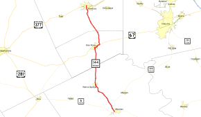
SH 144 begins at an intersection with SH 22 in Meridian.[2] The route travels northwest to Walnut Springs before turning in a more northerly direction. It enters Glen Rose, where it has a one-mile concurrency with US 67.[3] After separating from US 67, the highway resumes its northward journey to Granbury, where it intersects the US 377 bypass.[4] The SH 144 designation ends at an intersection with Bus. US 377 in central Granbury.[1]
History
SH 144 was designated by 1931 from Glen Rose to Meridian, with the extension north to Granbury designated by 1935.[1] An alignment of the route in Glen Rose was previously designated Spur 216 before being combined with SH 144 in 1949.[5]
Major intersections
| County | Location | mi[6][nb 1] | km | Destinations | Notes |
|---|---|---|---|---|---|
| Bosque | Meridian | 0.0 | 0.0 | SH 22 – Hamilton, Hillsboro | Southern terminus |
| Walnut Springs | 10.7 | 17.2 |  FM 927 west – Iredell FM 927 west – Iredell | South end of FM 927 concurrency | |
| 11.3 | 18.2 | FM 927 east – Morgan | North end of FM 927 concurrency | ||
| | 11.9 | 19.2 |  FM 203 FM 203 | ||
| Somervell | | 19.1 | 30.7 |  FM 202 FM 202 | |
| | 22.9 | 36.9 |  FM 56 south FM 56 south | South end of FM 56 concurrency | |
| Glen Rose | 23.7 | 38.1 |  FM 56 north to FM 205 FM 56 north to FM 205 | North end of FM 56 concurrency | |
| 25.0 | 40.2 | US 67 south – Stephenville | South end of US 67 concurrency | ||
| 26.0 | 41.8 | US 67 north – Cleburne | South end of US 67 concurrency | ||
| | 27.7 | 44.6 |  FM 200 – Rainbow FM 200 – Rainbow | ||
| Hood | | 31.9 | 51.3 |  FM 2425 (Mitchell Bend Hwy.) FM 2425 (Mitchell Bend Hwy.) | |
| | 34.3 | 55.2 | FM 2425 (Mambrino Hwy.) | ||
| Granbury | 39.5 | 63.6 | US 377 – Stephenville, Ft. Worth | ||
| 39.7 | 63.9 |  FM 51 south (Paluxy Hwy.) – Paluxy FM 51 south (Paluxy Hwy.) – Paluxy | South end of FM 51 concurrency | ||
| 40.1 | 64.5 |  Bus. US 377 (Pearl St.) / FM 51 north – Weatherford Bus. US 377 (Pearl St.) / FM 51 north – Weatherford | Northern terminus and north end of FM 51 concurrency | ||
| 1.000 mi = 1.609 km; 1.000 km = 0.621 mi | |||||
Notes
References
- 1 2 3 4 Transportation Planning and Programming Division (n.d.). "State Highway No. 144". Highway Designation Files. Texas Department of Transportation. Retrieved January 7, 2011.
- ↑ Transportation Planning and Programming Division (2014). Texas County Map Book (PDF) (Map) (2014 ed.). 1:120,000. Texas Department of Transportation. p. 360. Retrieved December 6, 2014.
- ↑ Transportation Planning and Programming Division (2014). Texas County Map Book (PDF) (Map) (2014 ed.). 1:120,000. Texas Department of Transportation. p. 359. Retrieved December 6, 2014.
- ↑ Transportation Planning and Programming Division (2014). Texas County Map Book (PDF) (Map) (2014 ed.). 1:120,000. Texas Department of Transportation. p. 358. Retrieved December 6, 2014.
- ↑ Transportation Planning and Programming Division (n.d.). "State Highway Loop No. 216". Highway Designation Files. Texas Department of Transportation. Retrieved January 7, 2011.
- ↑ Google (January 7, 2011). "Overview map of Texas State Highway 144 Distances Between Interchanges" (Map). Google Maps. Google. Retrieved January 7, 2011.